Des Plaines, Illinois facts for kids
Quick facts for kids
Des Plaines, Illinois
|
|||
|---|---|---|---|

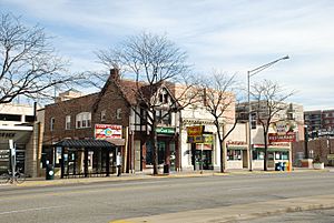
Downtown
|
|||
|
|||

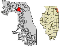
Location of Des Plaines in Cook County, Illinois
|
|||
| Country | United States | ||
| State | Illinois | ||
| County | Cook | ||
| Township | Maine | ||
| Settled | early 1800s | ||
| Incorporated | 1869 | ||
| Named for | Des Plaines River | ||
| Government | |||
| • Type | Council–manager | ||
| Area | |||
| • Total | 14.38 sq mi (37.26 km2) | ||
| • Land | 14.24 sq mi (36.88 km2) | ||
| • Water | 0.15 sq mi (0.38 km2) | ||
| Elevation | 642 ft (196 m) | ||
| Population
(2020)
|
|||
| • Total | 60,675 | ||
| • Rank | 20th in Illinois | ||
| • Density | 4,261.48/sq mi (1,645.36/km2) | ||
| Time zone | UTC−06:00 (CST) | ||
| • Summer (DST) | UTC−05:00 (CDT) | ||
| ZIP Codes |
60016–60019
|
||
| Area code(s) | 847, 224 | ||
| FIPS code | 17-19642 | ||
Des Plaines is a city in Cook County, Illinois, United States. It's a lively suburb of Chicago, located just north of O'Hare International Airport. The city gets its name from the Des Plaines River, which flows right through it. In 2020, about 60,675 people lived here.
Contents
History of Des Plaines
Native American tribes like the Potawatomi, Ottawa, and Ojibwe lived in the Des Plaines River Valley long before Europeans arrived. In the 1600s, French explorers and missionaries came to this area. They named the river La Rivière des Plaines, which means "Plains River." They thought the trees along the river looked like European plane trees.
The first white settlers arrived in 1833. Many German immigrants followed in the 1840s and 1850s. In the 1850s, land was bought along a planned railroad line. Developers built a mill to cut trees for railroad ties. Later, Socrates Rand bought the mill and turned it into a grist mill, which helped local farmers. The first train stopped here in 1854.
In 1857, a new railroad line started stopping near the mill. A small business area grew there, and the railroad named the future town Rand. In 1859, a different railroad company bought the line and changed the train station's name to "Des Plaines." In 1869, the town of Rand officially became the village of Des Plaines.
Des Plaines became a city in 1925. It grew quickly after World War II and when the nearby O'Hare International Airport opened.
In 1955, Des Plaines became famous for having the first McDonald's franchise. The original building was torn down in 1984, and a museum was built in its place. The museum was later removed in 2018 due to repeated flooding.
In 1979, a sad event happened when American Airlines Flight 191 crashed near Des Plaines. The plane had just left O'Hare Airport. Everyone on board, and two people on the ground, passed away.
In 2011, Rivers Casino opened in Des Plaines. It's a large casino located near the Tri-State Tollway. In 2022, one of the biggest lottery tickets in U.S. history, worth $1.34 billion, was sold at a gas station in Des Plaines!
Geography of Des Plaines
Des Plaines covers about 14.38 square miles (37.26 square kilometers). Most of this area is land, with a small part being water.
Two major interstate highways, I-90 and I-294, pass through Des Plaines. The city is named after the Des Plaines River, which flows through it. The name comes from an old French term for the American sycamore tree, which looks like the European plane tree.
The Des Plaines Crater
Underneath parts of Des Plaines, there's a special area called the "Des Plaines Disturbance." This is likely an ancient meteorite crater! It's about 75 to 200 feet (23 to 61 meters) below the town. The meteorite impact broke up the rocks deep underground. Over time, glaciers filled the crater, so you can't see any sign of it on the surface today.
Population of Des Plaines
As of the 2020 census, Des Plaines had 60,675 people living in the city. The population density was about 4,218 people per square mile.
The city is a diverse place. About 62% of the people were White, 15% were Asian, and 2% were African American. About 20% of the population identified as Hispanic or Latino.
The average age in Des Plaines was about 42.8 years old. About 20% of the population was under 18 years old.
Economy in Des Plaines
Des Plaines has several important employers. These include:
- Rivers Casino (Des Plaines)
- Universal Oil Products
- Oakton Community College
- Sysco Food Services
- Juno Lighting
- Holy Family Medical Center
- Wheels Inc. (a car and truck leasing company)
- LSG Sky Chefs
China Airlines also has its Chicago office located in Des Plaines.
Fun Things to Do in Des Plaines
Des Plaines offers many places for fun and learning:
- Big Bend Lake: A 27-acre lake connected to the Des Plaines River, great for fishing.
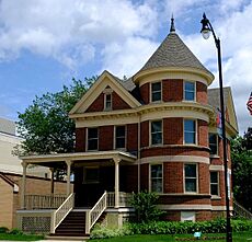
- Des Plaines History Center: Learn about the city's past. The Kinder House (1907) is part of the center.
- Des Plaines Methodist Camp Ground: This historic place was founded in 1860, even before the city! It still hosts concerts, day camps, swimming, and picnics every summer.
- Des Plaines Public Library: A great place to find books and resources.
- Des Plaines Theater: A historic movie theater from 1925, now renovated and hosting live shows.
- Lake Opeka in Lake Park: A lovely lake for outdoor activities.
- Mystic Waters Family Aquatic Center: A fun water park for families.
- Maryville Academy: A center that helps children in need. It's also home to the Chicagoland Sports Hall of Fame.
- Rivers Casino: A popular entertainment spot.
- 100 gecs tree: A unique local landmark.
Education in Des Plaines
Colleges
- Oakton College: This community college opened in 1969 and has campuses in Skokie and Des Plaines.
Public Schools
- Elementary and Middle Schools: Students attend schools in District 62, District 59, and District 63.
- High School: Older students go to Maine West High School, which is part of District 207.
Private Schools
- Immanuel Lutheran School
- The Science and Arts Academy
- The Willows Academy
Getting Around Des Plaines
Train Service
The Des Plaines station and Cumberland station offer Metra commuter train service. You can take trains southeast to Chicago Union Station or northwest to Harvard station or McHenry station.
Bus Service
Pace provides bus service with many routes that connect Des Plaines to other places in the region. The Pace Pulse Dempster Line also runs through the city.
Major Roads
Here are the main highways that pass through Des Plaines:
Famous People from Des Plaines
Many notable people have connections to Des Plaines:
- Adolph Bachmeier, a soccer player.
- Perry Caravello, an actor and comedian who lived here as a child.
- Eileen Fisher, a clothing designer who grew up in Des Plaines.
- Shawn Green, a two-time baseball All-Star who played for teams like the Toronto Blue Jays and LA Dodgers. He was born in Des Plaines.
- Peter M. Hoffman, a politician who served in Cook County.
- Michael Kleen, a folklorist and publisher.
- Tyler Ladendorf, a second baseman for the Oakland Athletics.
- Jill Morgenthaler, a US Army colonel and politician.
- Pelican, a post-metal band.
- Robert Reed, an actor famous for playing the dad on The Brady Bunch. He grew up in Des Plaines.
- Jacky Rosen, a United States Senator from Nevada. She was raised in Des Plaines for part of her childhood.
- Rick Zombo, a hockey defenseman who played for the Detroit Red Wings. He was born in Des Plaines.
- Marty Moylan, an Illinois State Representative and former Mayor of Des Plaines.
- Matthew Bogusz, an advertising executive who became Mayor of Des Plaines at a young age.
See also
 In Spanish: Des Plaines para niños
 | Kyle Baker |
 | Joseph Yoakum |
 | Laura Wheeler Waring |
 | Henry Ossawa Tanner |


