
Hazel Crest, Illinois facts for kids
Quick facts for kids
Hazel Crest, Illinois
|
||
|---|---|---|

Hazel Crest Fire Department
|
||
|
||

Location of Hazel Crest in Cook County, Illinois.
|
||

Hazel Crest, Illinois
Location in Greater Chicago

Hazel Crest, Illinois
Location in Illinois

Hazel Crest, Illinois
Location in the United States
|
||
| Country | ||
| State | Illinois | |
| County | Cook | |
| Townships | Bremen, Rich, Thornton | |
| Incorporated | 1911 | |
| Government | ||
| • Type | Council–manager | |
| Area | ||
| • Total | 3.42 sq mi (8.85 km2) | |
| • Land | 3.40 sq mi (8.80 km2) | |
| • Water | 0.02 sq mi (0.05 km2) 0.59% | |
| Population
(2020)
|
||
| • Total | 13,382 | |
| • Density | 3,939.36/sq mi (1,520.78/km2) | |
| Standard of living | ||
| • Per capita income | $24,424 | |
| • Median home value | $103,200 | |
| ZIP code(s) |
60429
|
|
| Area code(s) | 708 | |
| Geocode | 33695 | |
| FIPS code | 17-33695 | |
Hazel Crest is a village in Cook County, Illinois, United States. It's a suburb of Chicago, meaning it's a smaller town located near a big city. In 2020, about 13,382 people lived there.
Contents
History of Hazel Crest
Hazel Crest started as a farming community called South Harvey around 1870. A newspaper editor named William McClintock moved there in 1890. He bought land and named the town South Harvey.
McClintock built a train station for a local milk train. This station helped people travel to Chicago and other places. It was also the first real estate office, meeting place, school, and post office for the area.
In 1900, the town's name changed to Hazel Crest. This new name came from the many hazelnut bushes growing on a small hill south of town. Hazel Crest officially became a village in 1912. Many families who live there today are descendants of the first residents.
Later, a Community Church was built in 1894. An old elementary school building was turned into the Martin J. Kauchak Municipal Center in 1984. This center is named after President Kauchak, who led the village for 20 years.
Where is Hazel Crest Located?
Hazel Crest is located in Cook County, Illinois. It's about 25 miles (40 km) south of downtown Chicago. The village is mostly in Bremen Township. Some parts are in Rich Township and Thornton Township.
Hazel Crest shares its borders with several other towns:
- To the north: Markham
- To the northeast: Harvey
- To the east: East Hazel Crest
- To the southeast: Homewood
- To the south: Flossmoor
- To the west: Country Club Hills
The village covers about 3.42 square miles (8.85 km2) of land. It sits on a landform called the Tinley Moraine.
Who Lives in Hazel Crest?
| Historical population | |||
|---|---|---|---|
| Census | Pop. | %± | |
| 1920 | 438 | — | |
| 1930 | 1,162 | 165.3% | |
| 1940 | 1,299 | 11.8% | |
| 1950 | 2,129 | 63.9% | |
| 1960 | 6,205 | 191.5% | |
| 1970 | 10,329 | 66.5% | |
| 1980 | 13,973 | 35.3% | |
| 1990 | 13,334 | −4.6% | |
| 2000 | 14,816 | 11.1% | |
| 2010 | 14,100 | −4.8% | |
| 2020 | 13,382 | −5.1% | |
| U.S. Decennial Census 2010 2020 |
|||
In 2020, Hazel Crest had 13,382 residents. There were about 5,011 households, which are groups of people living together.
Most residents, about 86%, are African American. About 6% are White. Other groups include Native American, Asian, and people of two or more races. About 5.5% of the population is Hispanic or Latino.
About 30% of the people living in Hazel Crest are under 18 years old. The average age in the village is about 34.5 years.
Getting Around Hazel Crest
Hazel Crest has several ways for people to travel:
- Trains: The Metra Electric Line train runs through Hazel Crest. The Hazel Crest station connects commuters to downtown Chicago and University Park.
- Highways: Interstate 80 and the Tri-State Tollway (Interstate 294) meet in Hazel Crest. Several state highways also run through the village, like 175th Street and Kedzie Avenue.
- Buses: The Pace bus system serves Hazel Crest with several routes. These routes connect the village to nearby towns and other transportation hubs. Pace also offers special Dial-A-Ride services for elderly and disabled residents.
Major Roads in Hazel Crest
- 167th Street
- 175th Street
- 183rd Street
- Kedzie Avenue
- Pulaski Road (Crawford Avenue)
- Wood Street
- Dixie Highway
- Governors Highway
Jobs and Businesses in Hazel Crest
The Chicago Metropolitan Agency for Planning (CMAP) expects Hazel Crest to grow in population and jobs. Some of the main employers in the village include:
- Mi-Jack
- Advocate South Suburban Hospital
- Graycor Construction
- Giercyzk Real Estate
- Waterford Estates Retirement
Many of these businesses are located in the Palmer Lake Corporate Business Park.
Schools in Hazel Crest
Hazel Crest is served by several school districts for elementary, middle, and high schools.
Elementary Schools
- Prairie-Hills School District 144 operates Mae Jemison Elementary School, Highlands Elementary School, and Chateaux Elementary School in Hazel Crest.
- Hazel Crest School District 152.5 operates Woodland Elementary School and Warren Palm School in Hazel Crest.
- Flossmoor School District 161 operates five elementary schools outside the village that serve some Hazel Crest neighborhoods.
Middle Schools
There are no middle schools directly in Hazel Crest.
- Prairie-Hills Junior High School (District 144) in Markham serves most of the village.
- Robert Frost Middle School (District 152.5) in Markham serves areas east of California Avenue.
- Parker Junior High School (District 161) in Flossmoor serves areas south of 183rd Street.
High Schools
There are no high schools directly in Hazel Crest. Students attend high schools in nearby towns:
- Thornton Township High Schools District 205 operates Thornwood High School (for students east of California Avenue) and other high schools.
- Bremen Community High School District 228 operates Hillcrest High School in Country Club Hills (where most Hazel Crest high school students go), and other high schools.
- Homewood-Flossmoor Community High School District 233 operates Homewood-Flossmoor High School in Flossmoor (for students south of 175th Street).
Community Colleges
Hazel Crest is part of two community college districts:
- South Suburban College in South Holland (for residents north of 183rd Street).
- Prairie State College in Chicago Heights (for residents south of 183rd Street).
Homes in Hazel Crest
Hazel Crest has many different types of homes, including single-family houses, apartments, townhomes, and condominiums. Most of the subdivisions, which are areas with many homes, were built between the 1950s and 1980s.
Some of the largest neighborhoods include:
- Hazel Crest Proper (the oldest part of the village)
- Chateaux/Versailles
- Pottawatomie Hills/Twin Creeks
- Highlands
- Dynasty Lakes/Village West
- Pacesetter/Stonebridge/Carriage Hills
There are also many condominiums like English Valley and Stonebridge. The prices for homes in Hazel Crest can vary widely.
Advocate South Suburban Hospital

Hazel Crest is home to Advocate South Suburban Hospital. This hospital is part of Advocate Health Care, which is the largest hospital system in Illinois.
The hospital has 284 beds and nearly 400 doctors. It also has a maternity center where over 1,000 babies are born each year. This center provides 24-hour care for babies who need special attention.
The hospital first opened in 1946 as Hazel Crest General Hospital. In 1971, it moved to its current location. It joined Advocate Health Care in 1996. The hospital has grown and added new facilities over the years, including a cardiac catheterization laboratory for heart care.
Grande Prairie Public Library
Hazel Crest is part of the Grande Prairie Public Library District, which also includes Country Club Hills. The Grande Prairie Public Library is located at 3479 W. 183rd in Hazel Crest.
Residents of Hazel Crest can get a free library card. The library offers many programs and is a member of the Metropolitan Library System. The library district is managed by a board of seven trustees.
Parks and Recreation
The Hazel Crest Park District manages the parks and recreational activities in the village. This district has its own board of commissioners.
The Park District takes care of over 200 acres (0.81 km2) of parks. It also offers many fun programs for residents of all ages. In 2007, the Park District celebrated its 50th anniversary!
Images for kids
-
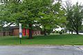
Hazel Crest Fire Department
-
Hazel Crest Logo
-
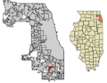
Location of Hazel Crest in Cook County, Illinois.
See also
 In Spanish: Hazel Crest para niños
