Markham, Illinois facts for kids
Quick facts for kids
Markham, Illinois
|
||
|---|---|---|
|
||
| Nickname(s):
Prairie Capital of the Prairie State
|
||
| Motto(s):
Unity for the Community
|
||

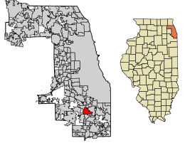
Location of Markham in Cook County, Illinois.
|
||
| Country | ||
| State | ||
| County | Cook | |
| Townships | Bremen, Thornton | |
| Incorporated | 1925 | |
| Area | ||
| • Total | 5.41 sq mi (14.00 km2) | |
| • Land | 5.41 sq mi (14.00 km2) | |
| • Water | 0.00 sq mi (0.00 km2) 0% | |
| Population
(2020)
|
||
| • Total | 11,661 | |
| • Density | 2,157.45/sq mi (833.01/km2) | |
| Standard of living (2007-2011) | ||
| • Per capita income | ,318 | |
| • Median home value | 0,300 | |
| ZIP code(s) |
60428
|
|
| Area code(s) | 708 | |
| Geocode | 47007 | |
| FIPS code | 17-47007 | |
Markham is a city located south of Chicago in Cook County, Illinois, United States. It's known as the "Prairie Capital of the Prairie State." The city's motto is "Unity for the Community." In 2020, about 11,661 people lived there.
History of Markham
Early Land and Native American Treaties
About 10,000 years ago, the area where Markham now stands was a beach! Over a very long time, it changed into swamps and marshes. Eventually, beautiful prairies with trees, flowers, and lots of wildlife covered the land.
Markham was an important crossroads for early pioneers. In 1816, a special agreement was made with the Odawa, Ojibwe, and Potawatomi tribes. This agreement gave a strip of land to settlers. This land stretched from north of the Chicago River to the mouth of the Calumet River.
The southern border of this land, called the Indian Treaty Boundary Line, was surveyed from the Kankakee River to Lake Michigan. You can still see this line on government maps today. A small part of Interstate 57 near U.S. Route 6 in Markham follows this historic line.
How Markham Grew into a City
The village of Markham officially became a town in 1925. At that time, fewer than 300 people lived there. The village was named after Charles H. Markham, who was the president of the Illinois Central Railroad for many years.
In the mid-1930s, a new neighborhood called Croissant Park was built. This caused the population to grow from 349 to 1,388 people. After World War II, Markham's population doubled again to 2,753 by 1950. The village became a "bedroom community," meaning people lived there but often worked in other cities.
An airport was built near 165th Street and Kedzie Avenue. This was the closest airport outside of Chicago. Today, the Cook County Sixth Circuit Courthouse is located near where the airport used to be. Markham officially became a city on August 24, 1967.
The Lone Pine Tree Symbol
In 1860, a German immigrant named Lawrence Roesner settled in the northwest part of Markham. He brought six small pine trees with him from the Black Forest in Germany. He planted them along the old Indian Boundary Line.
One of these trees became famous as the "Lone Pine Tree." In 1985, it was chosen as Markham's official city symbol. Sadly, the original lone pine tree died in 1986. The Markham City Council then decided to get a new tree from the Black Forest. The Markham Garden Club planted this replacement tree that same year.
Geography of Markham
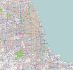
Markham is located at 41°35′51″N 87°41′30″W / 41.59750°N 87.69167°W. This means it's in the northern part of Illinois, not too far from Lake Michigan.
According to the 2010 census, Markham covers a total area of about 5.31 square miles (14.00 square kilometers). All of this area is land, with no large bodies of water within the city limits.
Population and People
How Markham's Population Has Changed
Markham's population has changed quite a bit over the years.
| Historical population | |||
|---|---|---|---|
| Census | Pop. | %± | |
| 1930 | 349 | — | |
| 1940 | 1,288 | 269.1% | |
| 1950 | 2,783 | 116.1% | |
| 1960 | 11,704 | 320.6% | |
| 1970 | 15,987 | 36.6% | |
| 1980 | 15,534 | −2.8% | |
| 1990 | 13,136 | −15.4% | |
| 2000 | 12,620 | −3.9% | |
| 2010 | 12,508 | −0.9% | |
| 2020 | 11,661 | −6.8% | |
| U.S. Decennial Census 2010 2020 |
|||
In 2020, there were 11,661 people living in Markham. There were 3,832 households and 2,821 families. The city had about 2,157 people per square mile.
Diversity in Markham
Markham is a diverse city with people from many different backgrounds. The table below shows the racial and ethnic makeup of Markham over the years.
| Race / Ethnicity (NH = Non-Hispanic) | Pop 2000 | Pop 2010 | Pop 2020 | % 2000 | % 2010 | % 2020 |
|---|---|---|---|---|---|---|
| White alone (NH) | 2,062 | 1,275 | 823 | 16.34% | 10.19% | 7.06% |
| Black or African American alone (NH) | 9,903 | 10,076 | 8,420 | 78.47% | 80.56% | 72.21% |
| Native American or Alaska Native alone (NH) | 13 | 15 | 11 | 0.10% | 0.12% | 0.09% |
| Asian alone (NH) | 75 | 84 | 103 | 0.59% | 0.67% | 0.88% |
| Pacific Islander alone (NH) | 2 | 8 | 0 | 0.02% | 0.06% | 0.00% |
| Other race alone (NH) | 7 | 22 | 32 | 0.06% | 0.18% | 0.27% |
| Mixed race or Multiracial (NH) | 162 | 191 | 258 | 1.28% | 1.53% | 2.21% |
| Hispanic or Latino (any race) | 396 | 837 | 2,014 | 3.14% | 6.69% | 17.57% |
| Total | 12,620 | 12,508 | 11,661 | 100.00% | 100.00% | 100.00% |
In 2020, the racial makeup of Markham was mostly African American (72.93%). There were also White (8.88%), Asian (0.91%), and Native American (0.39%) residents. About 10.26% were from other races, and 6.64% were from two or more races. People of Hispanic or Latino background made up 17.27% of the population.
Households and Age in Markham
Out of 3,832 households, about 39.9% had children under 18 living with them. About 28.42% were married couples. Many households (37.42%) had a female head with no husband present.
The average household size was 3.84 people, and the average family size was 3.23 people. The city's population included 31.2% under 18 years old. The median age in Markham was 32.0 years.
Education in Markham
Markham is served by several different school districts. Most of the city is part of Prairie-Hills School District 144. This district includes six elementary schools and Prairie-Hills Junior High School.
Other parts of Markham are served by:
- Posen-Robbins School District 143½ (four elementary schools and Thomas J. Kellar Middle School)
- Hazel Crest School District 152.5 (two elementary schools and Robert Frost Middle School)
- Harvey School District 152 (five elementary schools and Brooks Middle School)
For high school, most students in Markham attend Bremen High School. Other students go to Hillcrest High School or Tinley Park High School. These schools are all part of Bremen Community High School District 228. A different section of the city is served by Thornwood High School, which is in Thornton Township High School District 205.
City Services and Transportation
Police Department
The Markham Police Department is in charge of keeping the community safe and enforcing laws.
Public Transportation
Pace provides bus services in Markham. These bus routes connect Markham residents to many different places throughout the Southland area.
Notable People from Markham
Many interesting people have connections to Markham, Illinois.
- Randy Daniels was raised in Markham. He later became the secretary of state in New York and a deputy mayor of New York City.
- Floyd Fields grew up in Markham and played as a safety for the San Diego Chargers in professional football.
- Cliff Floyd was raised in Markham and played as an outfielder for the San Diego Padres in Major League Baseball.
- Rodney Harrison is from Markham. He was a safety for the New England Patriots and San Diego Chargers in professional football.
- Curtis Mayfield, a famous solo artist and member of the soul group the Impressions, once lived in Markham.
- Denny McLain was raised in Markham. He was a Major League Baseball pitcher and won the Cy Young Award.
- Corey McPherrin grew up in Markham. He is a news anchor and used to be a sportscaster for WFLD-TV.
- Kid Sister, a hip-hop artist, was raised in Markham and is sometimes called the "First Lady of Markham."
- Christopher "Tricky" Stewart, a hip-hop artist and producer, was born in Markham.
See also
In Spanish: Markham (Illinois) para niños
 | Janet Taylor Pickett |
 | Synthia Saint James |
 | Howardena Pindell |
 | Faith Ringgold |


