
Will County, Illinois facts for kids
Quick facts for kids
Will County
|
|
|---|---|
.jpg)  Flanders House in Plainfield (1840), Midewin National Tallgrass Prairie.
|
|

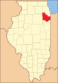
Location within the U.S. state of Illinois
|
|
 Illinois's location within the U.S. |
|
| Country | |
| State | |
| Founded | January 12, 1836 |
| Named for | Conrad Will |
| Seat | Joliet |
| Largest city | Joliet |
| Area | |
| • Total | 849 sq mi (2,200 km2) |
| • Land | 837 sq mi (2,170 km2) |
| • Water | 12 sq mi (30 km2) 1.5% |
| Population
(2020)
|
|
| • Total | 696,355 |
| • Density | 820.2/sq mi (316.68/km2) |
| Time zone | UTC−6 (Central) |
| • Summer (DST) | UTC−5 (CDT) |
| Congressional districts | 1st, 2nd, 11th, 14th |
Will County is a place called a county in the northeastern part of Illinois, a state in the United States. In 2020, about 696,355 people lived here. This makes it the fourth-biggest county in Illinois by population. The main city, or county seat, is Joliet. Will County is one of the five 'collar counties' around the big city of Chicago. This means it's part of the larger Chicago area.
Contents
History of Will County
Will County was created on January 12, 1836. It was formed from parts of Cook and Iroquois Counties. The county was named after Conrad Will. He was a politician and businessman who made salt in southern Illinois. Conrad Will was part of Illinois's first group that wrote the state's rules. He was also in the Illinois government until he passed away in 1835.
When it was first formed, Will County also included a part of Kankakee County, Illinois north of the Kankakee River. But in 1852, Kankakee County was created, and Will County lost that land. Since then, the borders of Will County have stayed the same.
There are 36 special places in Will County that are listed on the National Register of Historic Places. These places are important because of their history.
Geography and Nature
Will County covers a total area of about 849 square miles. Most of this is land (837 square miles), and a small part (12 square miles) is water.
The Kankakee River, Du Page River, and Des Plaines River all flow through the county. They meet up on the western edge of Will County. The Illinois and Michigan Canal and the Chicago Sanitary and Ship Canal also run through the county.
Many areas in Will County are protected as parks. The Forest Preserve District of Will County manages over 20,000 acres of these parks. One very large park is the Midewin National Tallgrass Prairie. It's about 17,000 acres and is managed by the U.S. Forest Service. This park is on the land where the Joliet Arsenal used to be. Other parks include Channahon State Park and the Des Plaines Fish and Wildlife Area.
Climate and Weather
| Weather chart for Joliet, Illinois | |||||||||||||||||||||||||||||||||||||||||||||||
|---|---|---|---|---|---|---|---|---|---|---|---|---|---|---|---|---|---|---|---|---|---|---|---|---|---|---|---|---|---|---|---|---|---|---|---|---|---|---|---|---|---|---|---|---|---|---|---|
| J | F | M | A | M | J | J | A | S | O | N | D | ||||||||||||||||||||||||||||||||||||
|
1.6
30
13
|
1.6
35
19
|
2.5
47
28
|
3.8
60
37
|
3.9
72
48
|
4.2
81
58
|
4.3
85
63
|
3.8
82
61
|
3.1
76
53
|
2.7
64
41
|
3
48
31
|
2.4
35
20
|
||||||||||||||||||||||||||||||||||||
| temperatures in °F precipitation totals in inches source: The Weather Channel |
|||||||||||||||||||||||||||||||||||||||||||||||
|
Metric conversion
|
|||||||||||||||||||||||||||||||||||||||||||||||
In Joliet, the main city, the average temperatures change throughout the year. In January, the average low is about 13°F. In July, the average high is about 85°F. The coldest temperature ever recorded was -26°F in January 1985. The hottest was 104°F in June 1988. The amount of rain also changes. January usually gets about 1.58 inches of rain, while July gets about 4.34 inches.
Neighboring Counties
Will County shares its borders with several other counties:
- Kane County (to the northwest)
- DuPage County (to the north)
- Cook County (to the northeast)
- Lake County, Indiana (to the east)
- Kankakee County (to the south)
- Grundy County (to the southwest)
- Kendall County (to the west)
Population and People
| Historical population | |||
|---|---|---|---|
| Census | Pop. | %± | |
| 1840 | 10,167 | — | |
| 1850 | 16,703 | 64.3% | |
| 1860 | 29,321 | 75.5% | |
| 1870 | 43,013 | 46.7% | |
| 1880 | 53,422 | 24.2% | |
| 1890 | 62,007 | 16.1% | |
| 1900 | 74,764 | 20.6% | |
| 1910 | 84,371 | 12.8% | |
| 1920 | 92,911 | 10.1% | |
| 1930 | 110,732 | 19.2% | |
| 1940 | 114,210 | 3.1% | |
| 1950 | 134,336 | 17.6% | |
| 1960 | 191,617 | 42.6% | |
| 1970 | 249,498 | 30.2% | |
| 1980 | 324,460 | 30.0% | |
| 1990 | 357,313 | 10.1% | |
| 2000 | 502,266 | 40.6% | |
| 2010 | 677,560 | 34.9% | |
| 2020 | 696,355 | 2.8% | |
| 2023 (est.) | 700,728 | 3.4% | |
| U.S. Decennial Census 1790–1960 1900–1990 1990–2000 2010 2020 |
|||
In 2010, there were 677,560 people living in Will County. About 76% of the people were white, 11.2% were Black or African American, and 4.6% were Asian. About 15.6% of the population was of Hispanic or Latino background.
The average family income in 2010 was about $85,488. About 6.6% of all people in the county lived below the poverty line. This included 9% of those under 18 years old.
Education in Will County
Will County has several places for higher education:
- Governors State University is a public university in University Park with about 6,000 students.
- Lewis University is a private university in Romeoville with about 5,200 students.
- University of St. Francis is a private university in Joliet with about 3,300 students.
- Joliet Junior College in Joliet is a two-year college. It was the first two-year college ever created in the United States!
School Districts
Many different school districts serve the kids in Will County. Some districts cover all grades (K-12), while others focus on secondary (high school) or elementary (younger grades) levels.
K-12 School Districts
- Beecher Community Unit School District 200U
- Coal City Community Unit School District 1
- Crete-Monee Community Unit School District 201-U
- Indian Prairie School District 204
- Manteno Community Unit School District 5
- Naperville Community Unit District 203
- Oswego Community Unit School District 308
- Peotone Community Unit School District 207U
- Plainfield School District 202
- Reed Custer Community Unit School District 255U
- Valley View Community Unit School District 365U
- Wilmington Community Unit School District 209U
High School Districts
- Bloom Township High School District 206
- Joliet Township High School District 204
- Lincoln Way Community High School District 210
- Lockport Township High School District 205
- Minooka Community High School District 111
Elementary School Districts
- Chaney-Monge School District 88
- Channahon School District 17
- Elwood Community Consolidated School District 203
- Fairmont School District 89
- Frankfort Community Consolidated School District 157C
- Homer Community Consolidated School District 33C
- Joliet Public School District 86
- Laraway Community Consolidated School District 70C
- Lockport School District 91
- Manhattan School District 114
- Minooka Community Consolidated School District 201
- Mokena School District 159
- New Lenox School District 122
- Richland School District 88A
- Rockdale School District 84
- Steger School District 194;
- Summit Hill School District 161
- Taft School District 90
- Troy Community Consolidated School District 30C
- Union School District 81
- Will County School District 92
Transportation and Travel
Will County has many ways to get around. Four major interstate highways, four U.S. highways, and 12 Illinois highways pass through the county. Pace also provides bus services for people to travel within the county.
Train Services
Four different Metra commuter train lines connect Will County to the Chicago Loop, which is downtown Chicago. These lines are the Metra Electric Main Line, Southwest Service, Rock Island District, and Heritage Corridor.
Amtrak also has a station in Will County at the Joliet Transportation Center. The Lincoln Service train goes between Chicago and St. Louis. The Texas Eagle train travels from Chicago south to San Antonio and west to Los Angeles.
Main Highways
 Interstate 55
 Interstate 57
 Interstate 80
 Interstate 355
 U.S. Highway 6
 U.S. Highway 30
 U.S. Highway 45
 U.S. Highway 52
 U.S. Highway 66
 Illinois Route 1
 Illinois Route 7
 Illinois Route 43
 Illinois Route 50
 Illinois Route 53
 Illinois Route 59
 Illinois Route 102
 Illinois Route 113
 Illinois Route 126
 Illinois Route 129
 Illinois Route 171
 Illinois Route 394
Energy and Industry
Will County is an important center for natural gas pipelines in the United States. Pipelines from Canada and the Gulf of Mexico meet here. Then, they spread out to deliver natural gas to the Midwest.
Joliet Refinery
ExxonMobil owns and runs the Joliet Refinery. This refinery is located along the Des Plaines River. It was built in 1972 and employs about 600 people.
Cities, Towns, and Areas
Will County is home to many different communities, from big cities to smaller villages and other named places.
Cities in Will County
- Aurora (mostly in other counties)
- Braidwood
- Crest Hill
- Joliet (partly in Kendall County)
- Lockport
- Naperville (mostly in DuPage County)
- Wilmington
Villages in Will County
- Beecher
- Bolingbrook (partly in DuPage County)
- Channahon (partly in Grundy County)
- Coal City (mostly in Grundy County)
- Crete
- Diamond (mostly in Grundy County)
- Elwood
- Frankfort (partly in Cook County)
- Godley
- Homer Glen(Partly in Cook County)
- Manhattan
- Minooka (mostly in Grundy & Kendall counties)
- Mokena
- Monee
- New Lenox
- Orland Park (mostly in Cook County)
- Oswego (mostly in Kendall County)
- Park Forest (mostly in Cook County)
- Peotone
- Plainfield (partly in Kendall County)
- Rockdale
- Romeoville
- Shorewood
- Steger (partly in Cook County)
- Symerton
- Tinley Park (mostly in Cook County)
- University Park (partly in Cook County)
- Woodridge (mostly in DuPage County)
Census-Designated Places
These are areas that are like towns but are not officially incorporated as cities or villages.
- Andres
- Arbury Hills
- Ballou
- Bonnie Brae
- Crystal Lawns
- Custer Park
- Eagle Lake
- Fairmont
- Frankfort Square
- Goodenow
- Goodings Grove (former)
- Ingalls Park
- Lakewood Shores
- Lockport Heights
- Lorenzo
- Marley
- Plum Valley
- Polk
- Preston Heights
- Rest Haven
- Ridgewood
- Ritchie
- Sunnyland
- Willow Brook Estates
- Wilton
- Wilton Center
Historic Fort
Townships
Townships are smaller local government areas within the county.
Images for kids
-
Will County from its 1836 creation to 1852
-

Will County in 1853, after Kankakee County was created


See also
 In Spanish: Condado de Will para niños
