
Kane County, Illinois facts for kids
Quick facts for kids
Kane County
|
|||
|---|---|---|---|
|
County
|
|||

The Fabyan Windmill in Geneva is on the National Register of Historic Places in Kane County, Illinois.
|
|||
|
|||

Location within the U.S. state of Illinois
|
|||
 Illinois's location within the U.S. |
|||
| Country | |||
| State | |||
| Founded | January 16, 1836 | ||
| Named for | Elias Kane | ||
| Seat | Geneva | ||
| Largest city | Aurora | ||
| Area | |||
| • Total | 524 sq mi (1,360 km2) | ||
| • Land | 520 sq mi (1,300 km2) | ||
| • Water | 4.1 sq mi (11 km2) 0.8% | ||
| Population
(2020)
|
|||
| • Total | 516,522 | ||
| • Estimate
(2023)
|
514,982 |
||
| • Density | 985.7/sq mi (380.6/km2) | ||
| Time zone | UTC−6 (Central) | ||
| • Summer (DST) | UTC−5 (CDT) | ||
| Congressional districts | 8th, 11th, 14th | ||


Kane County is a county in the state of Illinois, USA. It's located near Chicago and is one of the "collar counties" that surround the big city. In 2020, about 516,522 people lived here. This makes it the fifth-most populated county in Illinois. The main government center, called the county seat, is Geneva. The biggest city in Kane County is Aurora.
Contents
History of Kane County
Kane County was created in 1836. It was formed from a larger area called LaSalle County. The county was named after Elias Kane. He was an important person in Illinois history. Elias Kane served as a United States senator. He was also the first Secretary of State of Illinois.
Geography and Climate
Kane County covers about 524 square miles. Most of this area is land, with a small part being water. The largest cities in the county are located along the Fox River.
Weather in Kane County
| Weather chart for Geneva, Illinois | |||||||||||||||||||||||||||||||||||||||||||||||
|---|---|---|---|---|---|---|---|---|---|---|---|---|---|---|---|---|---|---|---|---|---|---|---|---|---|---|---|---|---|---|---|---|---|---|---|---|---|---|---|---|---|---|---|---|---|---|---|
| J | F | M | A | M | J | J | A | S | O | N | D | ||||||||||||||||||||||||||||||||||||
|
1.6
29
10
|
1.5
35
16
|
2.6
46
26
|
3.9
59
36
|
3.9
71
46
|
4.3
81
56
|
4.4
84
61
|
4.4
82
58
|
3.5
75
50
|
2.7
63
38
|
3.2
47
28
|
2.4
34
16
|
||||||||||||||||||||||||||||||||||||
| temperatures in °F precipitation totals in inches source: The Weather Channel |
|||||||||||||||||||||||||||||||||||||||||||||||
|
Metric conversion
|
|||||||||||||||||||||||||||||||||||||||||||||||
The weather in Kane County changes a lot throughout the year. In Geneva, the county seat, average temperatures are around 10°F in January. They can reach up to 84°F in July. The lowest temperature ever recorded was -26°F in January 1985. The highest was 111°F in July 1936. The county gets between 1.52 inches of rain or snow in February and 4.39 inches in July.
Neighboring Counties
Kane County shares borders with several other counties:
- McHenry County (to the north)
- Cook County (to the east)
- DuPage County (to the east)
- Will County (to the southeast)
- Kendall County (to the south)
- DeKalb County (to the west)
Parks and Outdoor Fun
Kane County has many places for outdoor activities. You can explore trails and nature preserves.
Popular Trails
- Fox River Trail
- Great Western Trail
- Illinois Prairie Path
- James "Pate" Philip State Park
Forest Preserves
The county has a large system of forest preserves. These are natural areas with trails, historic sites, and places to enjoy nature.
- Almon Underwood Prairie
- Andersen Woods
- Arlene Shoemaker
- Aurora West
- Barnes
- Big Rock Forest Preserve & Campground
- Binnie Forest Preserve
- Blackberry Maples
- Bliss Woods
- Bolcum Road Wetlands
- Bowes Creek Greenway Forest Preserve
- Bowes Creek Woods Forest Preserve
- Braeburn Marsh
- Brewster Creek Forest Preserve
- Brunner Family
- Buffalo Park Forest Preserve
- Burlington Prairie
- Burnidge Forest Preserve/Paul Wolff Campground
- Camp Tomo Chi-Chi Knolls
- Campton
- Cardinal Creek
- Culver
- Deer Valley Golf Course
- Dick Young
- Eagles Forest Preserve
- Edgewater Greenway Forest Preserve
- Elburn Forest Preserve
- Elgin Shores
- Fabyan
- Ferson Creek
- Fitchie Creek
- Fox River Bluff East & Fox River Bluff West
- Fox River Forested Fen Forest Preserve
- Fox River Shores
- Freeman Kame – Meagher
- Glenwood Park Forest Preserve
- Grunwald Farms
- Gunnar Anderson
- Hampshire Forest Preserve
- Hampshire South Forest Preserve
- Hannaford Woods/Nickels Farm
- Helm Woods
- Hoscheit Woods Forest Preserve
- Hughes Creek Golf Club
- Jack E. Cook Park & Forest Preserve
- Jelkes Creek
- Johnson's Mound
- Jon J. Duerr
- Kenyon Farm
- Lake Run Forest Preserve
- LeRoy Oakes
- Les Arends
- Lone Grove Forest Preserve
- McLean Fen Forest Preserve
- Meissner Prairie – Corron
- Mill Creek
- Muirhead Springs
- New Haven Park
- Oakhurst
- Otter Creek
- Pingree Grove Forest Preserve
- Poplar Creek
- Prairie Green
- Raceway Woods
- Raymond Street
- Regole
- Rutland Forest Preserve
- Sauer Family Prairie Kame
- Schweitzer Woods
- Settler's Hill
- Sleepy Hollow Ravine
- Tekakwitha Woods
- Tyler Creek Forest Preserve
- Virgil Forest Preserve
- Voyageur's Landing
- Willoughby Farms
Population and People
| Historical population | |||
|---|---|---|---|
| Census | Pop. | %± | |
| 1840 | 6,501 | — | |
| 1850 | 16,703 | 156.9% | |
| 1860 | 30,062 | 80.0% | |
| 1870 | 39,091 | 30.0% | |
| 1880 | 44,939 | 15.0% | |
| 1890 | 65,061 | 44.8% | |
| 1900 | 78,792 | 21.1% | |
| 1910 | 91,862 | 16.6% | |
| 1920 | 99,499 | 8.3% | |
| 1930 | 125,327 | 26.0% | |
| 1940 | 130,206 | 3.9% | |
| 1950 | 150,388 | 15.5% | |
| 1960 | 208,246 | 38.5% | |
| 1970 | 251,005 | 20.5% | |
| 1980 | 278,405 | 10.9% | |
| 1990 | 317,471 | 14.0% | |
| 2000 | 404,119 | 27.3% | |
| 2010 | 515,269 | 27.5% | |
| 2020 | 516,522 | 0.2% | |
| 2023 (est.) | 514,982 | −0.1% | |
| U.S. Decennial Census 1790–1960 1900–1990 1990–2000 2010–2019 |
|||
In 2020, Kane County had a population of 516,522 people. This number has grown a lot over the years. For example, in 1840, only about 6,501 people lived here.
The county is home to a diverse group of people. Many different backgrounds and cultures are represented. In 2010, about 74.6% of the people were white. About 5.7% were Black or African American, and 3.5% were Asian. People of Hispanic or Latino origin made up about 30.7% of the population.
The average age of people in Kane County in 2010 was 34.5 years. Many households (42.3%) had children under 18 living with them. The average household had almost 3 people.
Education in Kane County
Kane County has several colleges and universities. These schools offer many different programs for students.
- Aurora University
- Elgin Community College
- Judson University
- Waubonsee Community College
Transportation and Roads
Kane County has a good transportation system. This includes public transit and many highways.
Public Transit
- Metra: This is a commuter rail system. It helps people travel to and from Chicago.
- BNSF Line
- Milwaukee District West Line
- Union Pacific West Line
- Pace: This is a bus service. It provides local transportation within the county.
- Pace I-90 Express
Airport
- Aurora Municipal Airport: This airport serves general aviation.
Major Roads
Kane County has a large network of highways. These include federal, state, and county roads.
 Interstate 88
 Interstate 90
 U.S. Highway 20
 U.S. Highway 30
 U.S. Highway 34
 Illinois Route 19
 Illinois Route 25
 Illinois Route 31
 Illinois Route 38
 Illinois Route 47
 Illinois Route 56
 Illinois Route 58
 Illinois Route 62
 Illinois Route 64
 Illinois Route 68
 Illinois Route 72
 Illinois Route 110
 Army Trail Road
 Randall Road
 Longmeadow Parkway
- Kane County Route 37
- Lake Cook Road
Cities and Towns
Kane County has several cities and villages. Some of these are mostly within Kane County, while others are partly in neighboring counties.
Cities
- Aurora (mostly)
- Batavia (mostly)
- Elgin (mostly)
- Geneva (mostly)
- St. Charles (mostly)
Villages
- Algonquin (part)
- Barrington Hills (part)
- Bartlett (part)
- Big Rock
- Burlington
- Campton Hills
- Carpentersville
- East Dundee (mostly)
- Elburn
- Gilberts
- Hampshire
- Hoffman Estates (part)
- Huntley (part)
- Kaneville
- Lily Lake
- Maple Park (part)
- Montgomery (mostly)
- North Aurora
- Pingree Grove
- Sleepy Hollow
- South Elgin
- Sugar Grove
- Virgil
- Wayne (part)
- West Dundee
Census-designated place
Other Communities
These are smaller communities that are not officially cities or villages.
- Allens Corners
- Almora
- Bald Mound
- Bowes
- Five Island Park
- Freeman
- La Fox
- Mooseheart
- North Plato
- Nottingham Woods
- Plato Center
- Rainbow Hills
- Starks
- Thornwood
- Udina
- Valley View
- Wasco (former)
Townships
Townships are smaller local government areas within the county.
- Aurora Township
- Batavia Township
- Big Rock Township
- Blackberry Township
- Burlington Township
- Campton Township
- Dundee Township
- Elgin Township
- Geneva Township
- Hampshire Township
- Kaneville Township
- Plato Township
- Rutland Township
- St. Charles Township
- Sugar Grove Township
- Virgil Township
Notable People
Many interesting people have lived in or come from Kane County. You can find lists of them on the pages for these cities and towns:
- Geneva, Illinois
- Batavia, Illinois
- St. Charles, Illinois
- List of people from Elgin, Illinois
- List of people from Aurora, Illinois
- Carpentersville, Illinois
- East Dundee, Illinois
- Hampshire, Illinois
- Kaneville, Illinois
- Montgomery, Illinois
- Sugar Grove, Illinois
- West Dundee, Illinois
Images for kids
-
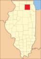
Kane County from 1836 to 1837, before DeKalb County was formed.
-
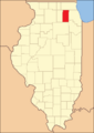
Kane County between 1837 and 1841.
-
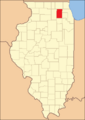
Kane County in 1841, showing its current size.
-
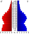
A chart showing the age groups of people in Kane County in 2000.


See also
 In Spanish: Condado de Kane (Illinois) para niños
