South Elgin, Illinois facts for kids
Quick facts for kids
South Elgin, Illinois
|
||
|---|---|---|
|
||
| Motto(s):
"Where Tradition Meets the Future"
|
||

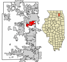
Location of South Elgin in Kane County, Illinois
|
||

Location of Illinois in the United States
|
||
| Country | United States | |
| State | Illinois | |
| County | Kane | |
| Townships | Elgin, St. Charles | |
| Area | ||
| • Total | 7.26 sq mi (18.81 km2) | |
| • Land | 7.06 sq mi (18.29 km2) | |
| • Water | 0.20 sq mi (0.52 km2) | |
| Elevation | 797 ft (243 m) | |
| Population
(2020)
|
||
| • Total | 23,865 | |
| • Density | 3,380.31/sq mi (1,305.11/km2) | |
| Time zone | UTC-6 (CST) | |
| • Summer (DST) | UTC-5 (CDT) | |
| ZIP code |
60177
|
|
| Area codes | 847 & 224 | |
| FIPS code | 17-70720 | |
| GNIS feature ID | 2399846 | |
| Wikimedia Commons | South Elgin, Illinois | |
South Elgin is a village located in Kane County, Illinois, in the United States. It's a special kind of town called a village. In 2020, about 23,865 people lived here. Money magazine even called South Elgin one of "America's Best Places to Live" in 2007 and 2011. This shows it's a great place to call home!
Contents
A Look Back: South Elgin's History
South Elgin wasn't always called South Elgin! It was first known as Clintonville. This name honored an early settler named James Clinton. The village officially changed its name to "South Elgin" in 1907.
Exploring South Elgin's Geography
South Elgin is found in the eastern part of Kane County. It sits right in the Fox River Valley. The city of Elgin is to its north. To the east, you'll find the village of Bartlett. A cool fact is that the Fox River flows right through South Elgin.
Land and Water Areas
In 2010, South Elgin covered a total area of about 7.16 square miles (18.54 square kilometers). Most of this area, about 6.99 square miles (18.10 square kilometers), is land. The rest, about 0.17 square miles (0.44 square kilometers), is water.
Who Lives in South Elgin?
| Historical population | |||
|---|---|---|---|
| Census | Pop. | %± | |
| 1890 | 505 | — | |
| 1900 | 515 | 2.0% | |
| 1910 | 580 | 12.6% | |
| 1920 | 559 | −3.6% | |
| 1930 | 745 | 33.3% | |
| 1940 | 961 | 29.0% | |
| 1950 | 1,220 | 27.0% | |
| 1960 | 2,624 | 115.1% | |
| 1970 | 4,289 | 63.5% | |
| 1980 | 6,218 | 45.0% | |
| 1990 | 7,474 | 20.2% | |
| 2000 | 16,100 | 115.4% | |
| 2010 | 21,985 | 36.6% | |
| 2020 | 23,865 | 8.6% | |
| U.S. Decennial Census 2010 2020 |
|||
Population in 2020
The 2020 census counted 23,865 people living in South Elgin. This table shows the different groups of people who call South Elgin home. It helps us understand the village's diverse community.
| Race / Ethnicity (NH = Non-Hispanic) | Pop 2010 | Pop 2020 | % 2010 | % 2020 |
|---|---|---|---|---|
| White alone (NH) | 15,936 | 14,935 | 72.49% | 62.58% |
| Black or African American alone (NH) | 679 | 821 | 3.09% | 3.44% |
| Native American or Alaska Native alone (NH) | 17 | 14 | 0.08% | 0.06% |
| Asian alone (NH) | 1,515 | 2,117 | 6.89% | 8.87% |
| Pacific Islander alone (NH) | 7 | 5 | 0.03% | 0.02% |
| Other race alone (NH) | 17 | 85 | 0.08% | 0.36% |
| Mixed race or Multiracial (NH) | 412 | 926 | 1.87% | 3.88% |
| Hispanic or Latino (any race) | 3,402 | 4,962 | 15.47% | 20.79% |
| Total | 21,985 | 23,865 | 100.00% | 100.00% |
Learning and Education
Children in South Elgin attend schools in two main school districts. These are Unit School District U46 and D303.
School District U46
U46 is a very large school district. It covers about 90 square miles (233 square kilometers). This area includes parts of Cook, DuPage, and Kane counties. Almost 40,000 students go to schools in U46. It is the second largest school district in all of Illinois.
School District D303
District 303 is also important for South Elgin students. It covers about 57 square miles (148 square kilometers). This district serves 13,590 students. It helps educate many young people in the Fox River Valley area.
Getting Around: Transportation
South Elgin has ways for people to travel both locally and further away.
Bus Service
Pace provides bus service in the area. Route 801 connects South Elgin to nearby towns. You can take the bus to Elgin, Geneva, and other places.
Train Lines
Two important train lines pass through South Elgin. The Chicago & North Western/Union Pacific line goes towards Rockford. The Illinois Central/Canadian National line heads towards Sioux City. These lines help move goods and sometimes people.
Fun Things to Do: Attractions
- Fox River Trolley Museum - This museum is a great place to visit. You can learn about old trolley cars and even ride some of them!
See also
 In Spanish: South Elgin para niños
 | Stephanie Wilson |
 | Charles Bolden |
 | Ronald McNair |
 | Frederick D. Gregory |


