
U.S. Route 34 facts for kids
Quick facts for kids
|
|
|---|---|
 |
|
| Route information | |
| Length | 1,122 mi (1,806 km) |
| Existed | 1926–present |
| Major junctions | |
| West end | |
|
|
| East end | |
| Location | |
| States: | Colorado, Nebraska, Iowa, Illinois |
| Highway system | |
| United States Numbered Highways List • Bannered • Divided • Replaced |
|

U.S. Route 34 (or US 34) is a very long road in the United States. It stretches for about 1,122 miles (1,806 km) from the mountains of Colorado all the way to the busy suburbs of Chicago. This highway goes from west to east, crossing four different states.
One of the most amazing parts of US 34 is in Rocky Mountain National Park in Colorado. Here, it's called the Trail Ridge Road. This section reaches an incredible height of 12,183 feet (3,713 meters) above sea level. This makes it one of the highest paved roads in the entire United States! For a short part of its journey in Colorado, US 34 is a toll road, meaning you pay a small fee to drive on it.
The western end of US 34 is in Granby, Colorado, where it meets US 40. Its eastern end is in Berwyn, Illinois, connecting with Illinois Route 43 and Historic US 66.
Contents
Exploring U.S. Route 34
US 34 is a major road that helps people travel across the country. It connects many towns and cities, making it an important route for both local drivers and those on long trips.
Colorado's Mountain Journey

In Colorado, US 34 starts in Granby and heads north. It then enters the beautiful Rocky Mountain National Park. As it winds through the park, it passes through Estes Park, a popular town for visitors. The road continues through cities like Loveland and Greeley. Finally, it leaves Colorado near Wray and enters Nebraska.
The part of US 34 inside Rocky Mountain National Park is known as Trail Ridge Road. Because it goes so high up into the mountains and crosses the Continental Divide, this section of the road closes completely during winter. It usually closes from mid-October until Memorial Day weekend in May. Sometimes, even in summer, it can close if there are big snowstorms in the mountains. This road crosses two mountain passes: Fall River Pass and Milner Pass.
Nebraska's Central Path
When US 34 enters Nebraska, it becomes a main east-west road in the southern part of the state. It comes into Nebraska west of Haigler. For much of its path, US 34 shares the road with other highways. It travels through cities like Hastings, Grand Island, Seward, and Lincoln. It then crosses the Platte River on the Plattsmouth Bridge to enter Iowa near Plattsmouth.
A section of US 34 between Hastings and Grand Island is called the Tom Osborne Expressway. This name honors a famous football coach and former Congressman from Nebraska. In Lincoln, US 34 joins Interstate 180 for a bit, leading into the downtown area. Another part of the highway is called the Bess Streeter Aldrich Memorial Highway, named after a well-known author who lived in Elmwood.
Iowa's Scenic Route

In Iowa, US 34 is a major east-west road across the southern part of the state. It enters Iowa west of Glenwood. The highway then goes through towns like Red Oak, Corning, and Creston. It meets Interstate 35 in Osceola. East of Osceola, it continues through Chariton and Albia. In Ottumwa, it meets U.S. Route 63 at a large traffic circle.
From Ottumwa to Burlington, US 34 travels alongside Iowa Highway 163. This part of the highway is a fast expressway, with some sections that are like a freeway. It goes around cities like Fairfield and Mount Pleasant. A section of this road also runs with US 218 and Iowa 27, which is part of the "Avenue of the Saints." The highway then heads southeast towards Burlington, bypassing other towns. The freeway part through Burlington was finished in the 1970s. It then crosses the Mississippi River on the impressive Great River Bridge to enter Illinois. This bridge was completed in the early 1990s. In 2015, a 15-mile section of US 34 in Montgomery and Adams counties won an award for having the best quality asphalt pavement in the country!
Much of this route was once called the Bluegrass Highway. It runs next to train tracks that were originally part of the Burlington and Missouri River Railroad. Today, these tracks belong to the BNSF. Amtrak's passenger train, the California Zephyr, also travels along this route. In Iowa, US 34 is officially named the Red Bull Highway. This is to honor the 34th Infantry (Red Bull) Division, a brave military group.
Illinois's Eastern Stretch

In Illinois, US 34 enters the state by crossing the Mississippi River from Burlington, Iowa. It passes through or around many cities, including Monmouth, Galesburg, Princeton, and Mendota. As it gets closer to Chicago, it goes through Oswego, Aurora, Naperville, and many other suburbs.
The highway generally travels from southwest to northeast in Illinois. Its eastern end is in Berwyn, where it meets Illinois Route 43 and Historic US 66. In the Chicago area, a large part of US 34 is known as "Ogden Avenue." This street is named after William Butler Ogden, who was Chicago's very first mayor. The entire highway in Illinois is also called the Walter Payton Memorial Highway. This name honors the famous football player Walter Payton, who played for the Chicago Bears and wore jersey number 34. The highway is about 211.37 miles (340.17 km) long within Illinois.
Future Plans for US 34
There are plans in Nebraska and Iowa to build a new bridge for US 34. This new bridge would change the route of US 34. It would go north of the Platte River and then turn east to cross the Missouri River south of Bellevue, Nebraska. After crossing the river, it would connect back to the current US 34 road near Glenwood, Iowa. This project aims to improve travel and connections between the two states.
Images for kids
-
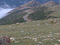
View of US 34 in Rocky Mountain National Park, from an elevation above 11,000 feet (3,353 meters).
-
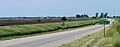
U.S. 34 in western Illinois.
| Browse numbered routes | ||||
|---|---|---|---|---|
| ← |
CO | SH 35 |
||
| ← |
NE | N-35 |
||
| ← |
IA | I-35 |
||
| ← |
IL | IL 34 |
||
