Milner Pass facts for kids
Quick facts for kids Milner Pass |
|
|---|---|
 |
|
| Elevation | 10,759 ft (3,279 m) |
| Traversed by | |
| Location | Grand / Larimer counties, Colorado, U.S. |
| Range | Front Range |
| Coordinates | 40°25′11″N 105°48′41″W / 40.41972°N 105.81139°W |
| Topo map | USGS Fall River Pass |
Milner Pass is a special place high up in the Rocky Mountains of Colorado, United States. It sits at an elevation of 10,759 ft (3,279 m), which is over two miles above sea level! This mountain pass is famous because it's part of the continental divide, a line that separates which ocean rivers flow into. It's also found inside the beautiful Rocky Mountain National Park.
Contents
Milner Pass: A High Mountain Journey
Milner Pass is located in the northern part of Colorado. It crosses the border between Larimer and Grand counties. This pass is a key part of US 34, which is also known as Trail Ridge Road. This road connects the towns of Estes Park and Grand Lake.
What is a Mountain Pass?
A mountain pass is like a low spot or a "doorway" through a mountain range. It makes it easier for people to travel from one side of the mountains to the other. Without passes, crossing huge mountains would be much harder! Milner Pass helps travelers get across the Front Range of the Rocky Mountains.
The Continental Divide
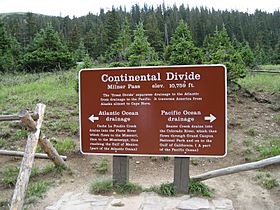
One of the most interesting things about Milner Pass is that it sits right on the continental divide. Imagine a giant invisible line running through North America. On one side of this line, all the rain and snow that falls will eventually flow into the Atlantic Ocean. On the other side, the water flows towards the Pacific Ocean. Milner Pass is one of the places where you can stand with one foot on each side of this amazing natural boundary!
- To the east of the pass, water from Poudre Lake forms the beginning of the Cache la Poudre River. This river eventually joins the Mississippi River and flows to the Atlantic.
- To the west, small creeks near the pass are the very start of the mighty Colorado River. This river travels all the way to the Pacific Ocean.
Exploring Trail Ridge Road
While Milner Pass is high, it's not the very highest point on Trail Ridge Road. That honor goes to another spot further east, which reaches an amazing 12,183 ft (3,713 m)! Trail Ridge Road is one of the highest continuous paved roads in North America. It offers incredible views and takes you through different types of landscapes, from forests to wide-open tundra.
Because of the huge amounts of snow, Milner Pass and the rest of Trail Ridge Road are usually closed during the winter. This closure typically lasts from October until late May or early June, around Memorial Day. When the road is open, you can see amazing panoramic views of the Never Summer Mountains to the west.
Why is it Called Milner Pass?
Milner Pass is named after a man named T.J. Milner. He was an engineer who explored the area a long time ago. Mr. Milner was looking for a good path to build a railroad over the mountains. Even though the railroad was never built, his work was remembered, and the pass was named in his honor.
 | Jackie Robinson |
 | Jack Johnson |
 | Althea Gibson |
 | Arthur Ashe |
 | Muhammad Ali |

