Grand County, Colorado facts for kids
Quick facts for kids
Grand County
|
||
|---|---|---|
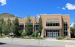
The Grand County Judicial Center in Hot Sulphur Springs, July 2016
|
||
|
||
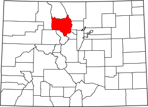
Location within the U.S. state of Colorado
|
||
 Colorado's location within the U.S. |
||
| Country | ||
| State | ||
| Founded | February 2, 1874 | |
| Named for | Grand Lake and Grand River | |
| Seat | Hot Sulphur Springs | |
| Largest town | Granby | |
| Area | ||
| • Total | 1,870 sq mi (4,800 km2) | |
| • Land | 1,846 sq mi (4,780 km2) | |
| • Water | 23 sq mi (60 km2) 1.2%% | |
| Population
(2020)
|
||
| • Total | 15,717 | |
| • Density | 8.5/sq mi (3.3/km2) | |
| Time zone | UTC−7 (Mountain) | |
| • Summer (DST) | UTC−6 (MDT) | |
| Congressional district | 2nd | |
Grand County is a county in the state of Colorado, USA. A county is like a smaller area within a state, often with its own local government. In 2020, about 15,717 people lived here. The main town and government center, called the county seat, is Hot Sulphur Springs.
Contents
History of Grand County
Grand County was created on February 2, 1874. It was formed from a part of Summit County. When it was first made, Grand County was much bigger. It stretched all the way to the western and northern borders of Colorado. Today, parts of it are in Moffat County and Routt County.
The county got its name from Grand Lake and the Grand River. The "Grand River" was an old name for the upper part of the Colorado River. This river starts in Grand County.
On January 29, 1877, Routt County was created. This made Grand County smaller, shrinking it to its current western border. Later, valuable minerals were found in an area called North Park. Both Grand County and Larimer County claimed this area. In 1886, the Colorado Supreme Court decided that North Park belonged to Larimer County. This decision set the northern border of Grand County.
Geography of Grand County
Grand County covers a total area of about 1,870 square miles (4,843 square kilometers). Most of this area, about 1,846 square miles (4,781 square kilometers), is land. The rest, about 23 square miles (60 square kilometers), is water.
Neighboring Counties
Grand County shares its borders with several other counties:
- Larimer County to the northeast
- Gilpin County to the east
- Boulder County to the east
- Clear Creek County to the southeast
- Summit County to the south
- Eagle County to the southwest
- Jackson County to the north
- Routt County to the west
Protected Natural Areas
Grand County is home to many beautiful natural areas that are protected. These areas help keep the environment safe and offer places for outdoor activities.
- Arapaho National Forest
- Arapaho National Recreation Area
- Byers Peak Wilderness
- Continental Divide National Scenic Trail
- Indian Peaks Wilderness
- Never Summer Wilderness
- Ptarmigan Peak Wilderness
- Rocky Mountain National Park
- Routt National Forest
- Sarvis Creek Wilderness
- Vasquez Peak Wilderness
Bicycle Routes
If you like biking, Grand County has some great routes:
- Great Parks Bicycle Route
- TransAmerica Trail Bicycle Route
Scenic Drives
There are also special roads where you can enjoy amazing views:
- Colorado River Headwaters National Scenic Byway
- Trail Ridge Road/Beaver Meadow National Scenic Byway
People of Grand County
In 2020, the population of Grand County was 15,717 people. The county is known for its beautiful mountain scenery and outdoor activities. Many people who live here enjoy nature and the relaxed lifestyle. The population includes people of various backgrounds and ages.
Towns and Communities
Grand County has several towns and smaller communities. These places offer different experiences, from lively ski towns to quiet mountain retreats.
Towns
- Fraser
- Granby
- Grand Lake
- Hot Sulphur Springs
- Kremmling
- Winter Park
Census-Designated Places
These are areas that are like towns but are not officially incorporated as cities or towns.
Other Communities
See also
 In Spanish: Condado de Grand (Colorado) para niños
 | Sharif Bey |
 | Hale Woodruff |
 | Richmond Barthé |
 | Purvis Young |


