Parshall, Colorado facts for kids
Quick facts for kids
Parshall, Colorado
|
|
|---|---|

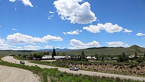
A view of Parshall from across U.S. Highway 40.
|
|

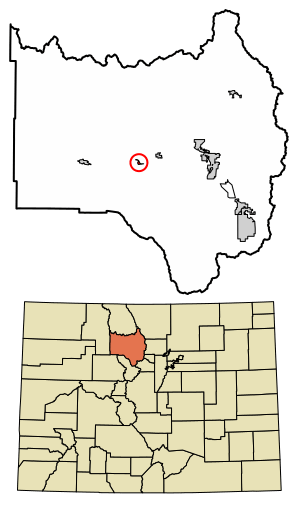
Location of the Parshall CDP in Grand County, Colorado.
|
|
| Country | |
| State | |
| County | Grand County |
| Government | |
| • Type | unincorporated town |
| Area | |
| • Total | 0.299 sq mi (0.774 km2) |
| • Land | 0.299 sq mi (0.774 km2) |
| • Water | 0 sq mi (0.000 km2) |
| Elevation | 7,586 ft (2,312 m) |
| Population
(2020)
|
|
| • Total | 42 |
| • Density | 140.5/sq mi (54.3/km2) |
| Time zone | UTC-7 (MST) |
| • Summer (DST) | UTC-6 (MDT) |
| ZIP Code |
80468
|
| Area code(s) | 970 |
| GNIS feature | 2583276 |
Parshall is a small community in Grand County, Colorado, United States. It is considered an unincorporated town and a CDP. This means it's a defined area for census purposes but doesn't have its own city government. Parshall has its own post office with ZIP Code 80468. In 2020, 42 people lived there.
Contents
What Is Parshall Like?
Parshall is located in the central part of Grand County. Its exact location is 40°03′24″N 106°10′29″W / 40.05667°N 106.17472°W. The area is known for its natural beauty and outdoor activities.
Parshall's Climate
Parshall has a subarctic climate. This type of climate is often called "Dfc" on climate maps. Winters are long and very cold, with short, clear days. Most of the precipitation, or rain and snow, comes as snow. The air is usually not very humid.
| Climate data for Parshall, Colorado | |||||||||||||
|---|---|---|---|---|---|---|---|---|---|---|---|---|---|
| Month | Jan | Feb | Mar | Apr | May | Jun | Jul | Aug | Sep | Oct | Nov | Dec | Year |
| Mean daily maximum °C (°F) | −3 (27) |
0 (32) |
6 (42) |
12 (53) |
17 (63) |
23 (73) |
26 (79) |
25 (77) |
21 (70) |
14 (57) |
5 (41) |
−2 (29) |
12 (54) |
| Mean daily minimum °C (°F) | −19 (−2) |
−17 (1) |
−11 (12) |
−6 (22) |
−1 (30) |
2 (36) |
6 (43) |
5 (41) |
0 (32) |
−5 (23) |
−11 (13) |
−17 (1) |
−6 (21) |
| Average precipitation mm (inches) | 23 (0.9) |
23 (0.9) |
25 (1) |
36 (1.4) |
36 (1.4) |
30 (1.2) |
46 (1.8) |
38 (1.5) |
41 (1.6) |
30 (1.2) |
28 (1.1) |
20 (0.8) |
370 (14.7) |
| Source: Weatherbase | |||||||||||||
Local Businesses and Work
The biggest business in Parshall is the Henderson Mill, located on County Road 3. This mill processes molybdenum ore. Molybdenum is a metal used to make strong steel. The ore comes from the Henderson Mine in Clear Creek County. This mine is just over the Continental Divide, a mountain range that separates rivers flowing to different oceans.
Many of the lower areas around Parshall are used for raising cattle.
Population Over Time
The United States Census Bureau first defined Parshall as a CDP for the United States Census 2010. Here's how the population has changed:
| Parshall CDP, Colorado | ||
|---|---|---|
| Year | Pop. | ±% |
| 2010 | 47 | — |
| 2020 | 42 | −10.6% |
| Source: United States Census Bureau | ||
See also
 In Spanish: Parshall (Colorado) para niños
 | May Edward Chinn |
 | Rebecca Cole |
 | Alexa Canady |
 | Dorothy Lavinia Brown |


