
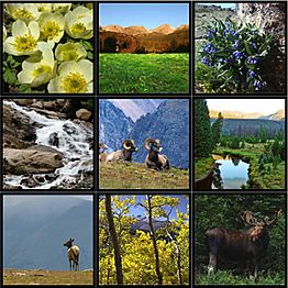
Rocky Mountain National Park facts for kids
Quick facts for kids Rocky Mountain National Park |
|
|---|---|
|
IUCN Category II (National Park)
|
|
| Location | Larimer / Grand / Boulder counties, Colorado, United States |
| Nearest city | Estes Park and Grand Lake, Colorado |
| Area | 265,461 acres (1,074.28 km2) |
| Established | January 26, 1915 |
| Visitors | 4,154,349 (in 2024) |
| Governing body | National Park Service |
| Website | Rocky Mountain National Park |
Rocky Mountain National Park is a national park in Colorado, USA. It is about 55 miles (88 km) northwest of Denver. The park sits within the Front Range of the Rocky Mountains. It is located between the towns of Estes Park to the east and Grand Lake to the west.
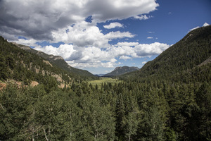
The Continental Divide runs through the middle of the park. The Colorado River starts in the park's northwestern area. The park is famous for its tall mountains, beautiful alpine lakes, and many kinds of wildlife. You can find different environments here, from thick forests to cold mountain tundra.
President Woodrow Wilson created the park on January 26, 1915. This protected the area for everyone to enjoy. The Civilian Conservation Corps built the main road, Trail Ridge Road, in the 1930s. In 1976, the United Nations named the park one of the first World Biosphere Reserves. In 2023, over 4.1 million people visited the park. It is one of the most popular national parks in the country.
The park has five visitor centers. Its main office is at the Beaver Meadows Visitor Center. This building is a National Historic Landmark. It was designed by the Frank Lloyd Wright School of Architecture. National forests surround the park on all sides. These include Roosevelt National Forest and Arapaho National Forest.
Park History

The story of Rocky Mountain National Park began a long time ago. Early people called Paleo-Indians hunted and gathered food here. They traveled a route near what is now Trail Ridge Road. Later, the Ute and Arapaho tribes lived and hunted in these mountains.
In the 1820s, the Long Expedition explored the Rockies. Longs Peak is named after its leader, Stephen Harriman Long. In the mid-1800s, settlers arrived. Native American tribes moved from the area by 1878.
In the 1870s, towns like Lulu City grew as people searched for gold and silver. But by 1883, the mining boom ended, and the towns were left behind. A railroad reached Lyons, Colorado in 1881. The Big Thompson Canyon Road, part of U.S. Route 34, was finished in 1904. The 1920s brought more lodges and roads. Trail Ridge Road was built in stages, finished to Fall River Pass by 1932 and to Grand Lake by 1938.
People like Enos Mills worked hard to make this area a national park. The park was officially created on January 26, 1915.
Park Geography

Rocky Mountain National Park covers over 265,000 acres (1,074 square kilometers) of land. Nearby national forests add even more protected wilderness. The Continental Divide splits the park from north to south. Rivers on the west side flow to the Pacific Ocean. Rivers on the east side flow to the Atlantic Ocean.
In the Never Summer Mountains, the Continental Divide makes a strange horseshoe shape. This means some streams on the east side flow to the Pacific. Meanwhile, some streams on the west side flow to the Atlantic!
The famous Colorado River starts in the park's northwest. The park has about 450 miles (720 km) of rivers and streams. It also has 350 miles (560 km) of trails and 150 lakes.
It's one of the highest national parks. Elevations range from 7,860 feet (2,396 m) to 14,259 feet (4,346 m) at Longs Peak. Sixty peaks are over 12,000 feet (3,700 m) tall, offering amazing views. The Mummy Range in the north has many tall peaks, like Hagues Peak and Mummy Mountain. Small glaciers and snowfields can be found in the high mountain bowls.

Mountain passes like Baker Pass and Thunder Pass cross the high mountains. Thunder Pass was once used by stagecoaches.
Park Climate
The park's weather changes a lot due to its high mountains and different air currents. When cold arctic air from the north meets warm, moist air from the Gulf of Mexico, it can cause huge snowfalls.
| Climate data for Bear Lake Ranger Station, Rocky Mountain National Park. Elev: 9583 ft (2921 m) | |||||||||||||
|---|---|---|---|---|---|---|---|---|---|---|---|---|---|
| Month | Jan | Feb | Mar | Apr | May | Jun | Jul | Aug | Sep | Oct | Nov | Dec | Year |
| Mean daily maximum °F (°C) | 28.6 (−1.9) |
30.8 (−0.7) |
37.5 (3.1) |
44.1 (6.7) |
53.2 (11.8) |
63.7 (17.6) |
70.7 (21.5) |
68.6 (20.3) |
60.7 (15.9) |
49.2 (9.6) |
36.0 (2.2) |
28.3 (−2.1) |
47.7 (8.7) |
| Daily mean °F (°C) | 20.1 (−6.6) |
21.2 (−6.0) |
26.9 (−2.8) |
33.0 (0.6) |
41.5 (5.3) |
50.5 (10.3) |
56.9 (13.8) |
55.4 (13.0) |
48.2 (9.0) |
38.6 (3.7) |
27.4 (−2.6) |
20.0 (−6.7) |
36.7 (2.6) |
| Mean daily minimum °F (°C) | 11.6 (−11.3) |
11.7 (−11.3) |
16.2 (−8.8) |
21.8 (−5.7) |
29.7 (−1.3) |
37.2 (2.9) |
43.0 (6.1) |
42.1 (5.6) |
35.6 (2.0) |
28.0 (−2.2) |
18.9 (−7.3) |
11.6 (−11.3) |
25.7 (−3.5) |
| Average precipitation inches (mm) | 2.72 (69) |
2.97 (75) |
3.83 (97) |
4.34 (110) |
3.39 (86) |
2.11 (54) |
2.21 (56) |
2.20 (56) |
2.10 (53) |
2.39 (61) |
3.04 (77) |
3.11 (79) |
34.41 (874) |
| Average relative humidity (%) | 56.5 | 56.4 | 54.3 | 54.3 | 55.2 | 50.1 | 48.6 | 54.2 | 50.0 | 47.2 | 52.5 | 57.3 | 53.0 |
| Average dew point °F (°C) | 7.1 (−13.8) |
8.1 (−13.3) |
12.6 (−10.8) |
18.3 (−7.6) |
26.6 (−3.0) |
32.6 (0.3) |
37.7 (3.2) |
39.1 (3.9) |
30.4 (−0.9) |
20.2 (−6.6) |
12.3 (−10.9) |
7.3 (−13.7) |
21.1 (−6.1) |
| Source: PRISM Climate Group | |||||||||||||
| Climate data for Beaver Meadows Visitor Center, Rocky Mountain National Park. Elev: 7877 ft (2401 m) | |||||||||||||
|---|---|---|---|---|---|---|---|---|---|---|---|---|---|
| Month | Jan | Feb | Mar | Apr | May | Jun | Jul | Aug | Sep | Oct | Nov | Dec | Year |
| Mean daily maximum °F (°C) | 36.4 (2.4) |
38.4 (3.6) |
44.2 (6.8) |
50.7 (10.4) |
60.1 (15.6) |
71.2 (21.8) |
78.1 (25.6) |
76.1 (24.5) |
68.1 (20.1) |
56.7 (13.7) |
43.5 (6.4) |
35.9 (2.2) |
55.0 (12.8) |
| Daily mean °F (°C) | 25.8 (−3.4) |
26.9 (−2.8) |
32.4 (0.2) |
38.4 (3.6) |
47.0 (8.3) |
56.1 (13.4) |
62.4 (16.9) |
60.6 (15.9) |
53.0 (11.7) |
43.5 (6.4) |
33.0 (0.6) |
25.7 (−3.5) |
42.1 (5.6) |
| Mean daily minimum °F (°C) | 15.1 (−9.4) |
15.5 (−9.2) |
20.6 (−6.3) |
26.1 (−3.3) |
34.0 (1.1) |
40.9 (4.9) |
46.6 (8.1) |
45.1 (7.3) |
37.9 (3.3) |
30.3 (−0.9) |
22.6 (−5.2) |
15.6 (−9.1) |
29.3 (−1.5) |
| Average precipitation inches (cm) | — | 0.81 (2.1) |
1.94 (4.9) |
2.36 (6.0) |
2.48 (6.3) |
1.99 (5.1) |
2.39 (6.1) |
2.02 (5.1) |
1.46 (3.7) |
1.04 (2.6) |
0.87 (2.2) |
0.83 (2.1) |
18.95 (48.1) |
| Average relative humidity (%) | 46.3 | 46.9 | 48.0 | 47.8 | 50.6 | 45.3 | 45.6 | 49.7 | 46.1 | 42.9 | 44.5 | 47.8 | 46.8 |
| Average dew point °F (°C) | 8.0 (−13.3) |
9.3 (−12.6) |
14.9 (−9.5) |
20.3 (−6.5) |
29.6 (−1.3) |
35.2 (1.8) |
41.1 (5.1) |
41.7 (5.4) |
32.8 (0.4) |
22.4 (−5.3) |
13.7 (−10.2) |
8.6 (−13.0) |
23.2 (−4.9) |
| Source: PRISM Climate Group | |||||||||||||
Elevation and Weather
Higher areas get twice as much snow as lower areas. Winters in the high mountains are very cold with blizzards and strong winds. You need special gear for overnight trips in these conditions.

Spring arrives in the subalpine areas around June. Wildflowers bloom from late June to early August.
Below 9,400 feet (2,900 m), temperatures are usually mild, but nights are cool. In the lower montane areas, spring starts in early May with wildflowers. The weather can change quickly, and snow can fall on trails even in May. In July and August, daytime temperatures are often 70-80°F (21-27°C). Nights can drop to 40°F (4°C). Lower areas get rain in summer.
Summer afternoons can bring sudden thunderstorms. These can drop temperatures by 20°F (11°C) and bring strong winds.
Continental Divide's Climate Impact
The Continental Divide also affects the climate. It runs through the park's high peaks. The west side of the park gets more snow and less wind in winter. The east side near Estes Park has different weather patterns.
Studying Climate Change
Rocky Mountain National Park is part of a climate change study. Scientists from National Aeronautics and Space Administration and other groups started this study in 2011. They want to understand how climate change affects the park's plants and animals. They also look for ways to protect them.

Records show the park's average temperature increased by about 3°F (1.7°C) over the last 100 years. This warming means snow melts earlier, leading to drier summers and longer fire seasons. Also, mountain pine beetles are thriving more. They are killing more trees in the park.
Scientists expect temperatures to keep rising, especially in summer. This could mean less snow, more evaporation, and possibly more droughts. It also means a higher chance of intense rainstorms.
Park Geology
Billions of years ago, very old rocks formed the base of North America here. Later, a shallow sea covered this area. It left behind thick layers of rock like limestone. Molten rock flowed and cooled, forming granite. Over millions of years, the land sank, and layers of sand and mud built up.
Around 300 million years ago, the land pushed up to form the ancient Rocky Mountains. These mountains slowly wore down and were buried under new layers of rock.

About 70 million years ago, a deep sea covered the area again. It left behind shale rock with fossils of sea creatures like ammonites and ancient reptiles. Eventually, the sea dried up, and the land became dry again.
Around 68 million years ago, the Front Range started to rise. This created the Rocky Mountains we see today. This process also shaped the rivers and streams.
Glaciers and Landforms

You can see the effects of glaciers all over Rocky Mountain National Park. Huge moving ice masses carved out the mountains and valleys. Glaciers removed thousands of feet of rock, showing the older rocks underneath.
Even though most glaciers are gone, the park still has several small ones. These include Andrews, Sprague, Tyndall, Taylor, Rowe, Mills, and Moomaw Glaciers.
Little Yellowstone has cool rock features, much like the famous Grand Canyon of the Yellowstone. The Mummy Range is a mountain range in the north. Its peaks are often gentler and more forested. Lumpy Ridge is a granite outcrop that was not worn down by glaciers. Its granite is 1.8 billion years old.
Park Ecology
Colorado has many different plants and animals. This is because of the big temperature changes at different elevations. The Continental Divide creates two different climates in the park. The east side is drier with rocky peaks. The west side is wetter with lush forests.
The park has four main ecosystems, or zones: montane, subalpine, alpine tundra, and riparian. The riparian zone is found within all the other zones. Each ecosystem has living things interacting with each other and their environment.
The United Nations named the park a World Biosphere Reserve in 1976. This helps protect its natural resources. Scientists study animals, plants, and water here. They also look at how global change affects the park.
Even with protection, the park faces air pollution from nearby cities.
Montane Zone: Forests and Meadows
The montane zone is the lowest part of the park, from 5,600 to 9,500 feet (1,700 to 2,900 m). Here, you find forests and large meadows. This area has the most diverse plant and animal life. Rivers wind through the valleys, and wildflowers bloom in summer.
Dry, south-facing slopes have ponderosa pine trees, grass, and shrubs. North-facing slopes stay wetter. They support dense forests of Douglas fir, lodgepole pine, and ponderosa pine. You might also see Engelmann spruce and blue spruce. Quaking aspens grow well in wet montane soils. Along streams, you can find willows and other water-loving trees.
Some animals living here include snowshoe hares, coyotes, cougars, beavers, mule deer, moose, bighorn sheep, black bears, and Rocky Mountain elk. In the fall, many visitors come to see the elk during their mating season.
Subalpine Zone: High Forests and Lakes

From 9,000 to 11,000 feet (2,700 to 3,400 m), the montane forests change to subalpine forests. Here, fir and Engelmann spruce trees cover the mountainsides. Lower down, trees are tall. But closer to the tree line, they become shorter and twisted. This low, dense growth of trees is called krummholz. These trees can live for hundreds of years.
In areas that have burned, you might see lodgepole pines and huckleberry bushes. Clear lakes and fields of wildflowers are hidden among the trees. Animals here include bobcats, cougars, coyotes, elk, mule deer, chipmunks, and yellow-bellied marmots. Black bears like the berries and seeds in these forests. Birds like Clark's nutcracker and Steller's jay also live here. Sprague Lake and Odessa Lake are beautiful subalpine lakes.
Alpine Tundra: Above the Trees

Above 11,000 feet (3,400 m), the trees disappear. This is the vast alpine tundra. Over one-third of the park is above the tree line. The cold climate and strong winds make it hard for plants to grow. Most plants here are perennials. Many alpine plants are small, but their flowers can be full-sized.
Cushion plants have long roots that go deep into the rocky soil. Their small size helps protect them from strong winds. Many tundra flowers have dense hairs on their stems and leaves. This helps protect them from the wind. Some plants have red colors to turn sunlight into heat. Some plants take years to form flower buds. These buds survive winter underground and then bloom quickly in the short summer. Grasses and sedges are common where the soil is well-developed.
Non-flowering lichens cling to rocks and soil. They can make food in temperatures above freezing. Tundra plants are tough, but they are also fragile. Footsteps can harm them, and it can take hundreds of years for them to recover.
Animals that live in the alpine tundra include bighorn sheep, elk, pikas, and yellow-bellied marmots. Birds like prairie falcons and white-tailed ptarmigans are also found here.
Riparian Zone: Life Along Water
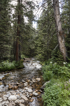
The riparian zone follows streams, rivers, and lakes. It runs through the montane, subalpine, and alpine tundra zones. This zone is very important for many species. The Colorado River starts on the west side of the park. The Fall River, Cache la Poudre River, and Big Thompson Rivers are on the east side.
The climate in riparian zones varies. Valleys are cooler than slopes. The amount of rain or snow also changes. These differences affect the types of plants and animals found in each riparian area.
Park Wildlife
Rocky Mountain National Park is home to many animals. It has nearly 70 types of mammals and almost 300 kinds of birds. This variety is due to the park's different habitats. Some animals, like wolves and grizzly bears, are no longer found here. Moose were not originally in this area but were brought back in 1978.
Elk Population and Management
The park has about 2,000 to 3,000 elk in summer. About 800 to 1,000 elk stay in the park during winter. Because there are no wolves, the park sometimes removes about 50 elk each winter. Too many elk can eat too much vegetation in wet areas. So, the park puts up fences to protect plants like willows and aspens. This helps these plants grow back.
Other Hoofed Animals

Many other hoofed animals live in the park. These include bighorn sheep, moose, and mule deer. Bison and pronghorn were gone from the park by the 1800s. Moose were brought back in 1978 and are now often seen, especially on the park's west side. The park's bighorn sheep population has grown to about 350 animals.
Predators in the Park
The park is home to many predators. These include Canada lynx, foxes, bobcats, cougars, black bears, and coyotes. Wolves and grizzly bears were removed in the early 1900s. Most predators hunt smaller animals. But mountain lions and coyotes sometimes hunt deer and elk. Bears also eat larger prey. Moose have no predators in the park.
Black bears are not very common here, with only about 24–35 animals. They also have fewer cubs and seem thinner than bears in other areas. Canadian lynx are rare in the park. Cougars mainly eat mule deer and can live for 10–13 years. Their hunting areas can be very large. Coyotes hunt alone, in pairs, or sometimes in packs. They mostly eat rodents but can also hunt larger animals like deer and elk calves. Coyotes form strong family bonds and are very vocal.
Visiting the Park and Activities

The park has four entrances. Three are on the east side near Estes Park, and one is on the west side near Grand Lake. About 3 million people visit the park each year. The park also has five visitor centers. To manage crowds, the park started a timed-entry system in 2020. From May to October, most visitors need a reservation to enter.
Trail Ridge Road, also known as U.S. Route 34, connects the east and west sides of the park. It is the highest continuously paved highway in the country. Its highest point is 12,183 feet (3,713 m). In winter, most of Trail Ridge Road closes due to heavy snow. This limits car access to the edges of the park.
The park has many trails for hiking. Most trails are best for summer use. At other times, many trails are not safe due to weather.

Fishing is allowed in many of the park's lakes and streams. Four types of trout live in the park's waters: rainbow, brook, cutthroat, and German brown trout.
Other activities in the park include rock climbing, mountaineering, snowshoeing, and cross-country skiing.
Park Safety and Wildfires
It's important to be aware of safety when visiting the park. You might encounter bears. Other concerns include bugs, wildfires, bad snow conditions, and cold nighttime temperatures.
There have been accidents over the years, including falls from steep cliffs and falling rocks. According to the National Park Service, there were 77 deaths in the park between 2007 and 2024. Most were from accidental falls while hiking or climbing.
Wildfires in the Park
Wildfires have happened in Rocky Mountain National Park for a long time. Some notable fires include the Bear Lake Fire in 1900. It started from a campfire and burned for two months. The Ouzel Fire in 1978 was caused by lightning. It was allowed to burn under watch but grew out of control, burning 1,050 acres. The Fern Lake Fire in 2012 also started from a campfire. Strong winds and dry conditions made it worse. It burned for over two months and covered nearly 3,500 acres.
Warmer temperatures in the Rocky Mountains mean less snow and earlier snowmelt. This leads to drier summers and longer fire seasons. Rocky Mountain National Park is expected to see more wildfires. These fires may also last longer and be more intense.
High-severity wildfires can harm the ecosystem. They can damage soil, making it harder to absorb water. They also increase erosion and the risk of floods and mudslides. Ash from fires can pollute the air and water.
However, low-severity wildfires are important for a healthy ecosystem. They help prevent damaging high-severity fires by clearing away dead plants. This material can fuel larger fires. Smaller fires also add nutrients to the soil and make room for new plant growth. They can also help fight against invasive plant species.
Many parks, including Rocky Mountain National Park, use small, controlled fires. This helps prevent bigger, more dangerous fires. Other methods include removing low branches and thinning forests. Scientists are working to find a balance. They want to let fires help the ecosystem while avoiding damage and pollution.
See also
 In Spanish: Parque nacional de las Montañas Rocosas para niños
- List of areas in the United States National Park System – places like parks, monuments, and historic sites
- Birds of Rocky Mountain National Park
- List of national parks of the United States
- Southern Rocky Mountain Front - where the Rocky Mountains meet the plains
