
Continental Divide of the Americas facts for kids
The Continental Divide of the Americas is like a giant, imaginary line that runs mostly along the highest points of mountains in North and South America. It's also called the Great Divide. This line separates the rivers and streams that flow into the Pacific Ocean from those that flow into the Atlantic Ocean (including the Gulf of Mexico and Caribbean Sea) and the Arctic Ocean.
Think of it as a roof ridge on a house. Rain falling on one side of the roof goes one way, and rain falling on the other side goes the opposite way. The Continental Divide works similarly for water across the continents. It stretches all the way from the Bering Strait in the north to the Strait of Magellan at the southern tip of South America. While there are other places where water divides, this one is the most famous because it follows the tall peaks of the Rocky Mountains and the Andes.
Contents
Where the Divide Goes
The Continental Divide starts way up north in Arctic Alaska, near the Beaufort Sea. From there, it zig-zags south through Yukon in Canada. It then crosses through British Columbia, following mountain ranges like the Cassiar Mountains and Omineca Mountains. It eventually reaches the main part of the Canadian Rockies, forming part of the border between British Columbia and Alberta.
The Divide then enters the United States in Montana, right at the edge of Waterton Lakes National Park and Glacier National Park. It continues south through Montana, passing near cities like Helena and Butte. It then goes into Wyoming, through Yellowstone National Park, and around a unique area called the Great Divide Basin.

In Colorado, the Divide reaches its highest point in North America at the top of Grays Peak, which is 4,352 meters (14,278 feet) tall. It then moves into New Mexico, passing by the Plains of San Agustin.
Moving south, the Divide crosses through many states in Mexico, including Chihuahua and Jalisco. In Central America, it continues through countries like Guatemala, Honduras, Nicaragua, Costa Rica, and Panama. The lowest natural point of the Divide in Central America is only 47 meters (154 feet) high at the Isthmus of Rivas in Nicaragua. The Panama Canal even cuts through the Divide at 26 meters (85 feet) above sea level!

Finally, the Divide enters South America, following the tall peaks of the Andes Mountains. It goes through western Colombia, central Ecuador, Peru, and along the eastern side of Chile, often forming the border with Bolivia and Argentina. It continues all the way to the southern tip of Patagonia and Tierra del Fuego.
Other Water Divides
Besides the main Continental Divide, there are other important water divides in North America. For example, the Arctic Divide in Canada separates water flowing to the Arctic Ocean from water flowing into Hudson Bay. Another divide, called the Laurentian Divide, separates the Hudson Bay/Arctic Ocean area from the Atlantic Ocean watershed. There's also a divide along the Appalachian Mountains that separates rivers flowing directly to the Atlantic from those that join the Mississippi River.
Special "Triple Points"
A "triple point" on a divide is a very special place where water can flow in three different directions, usually towards three different oceans.

Triple Divide Peak
One of the most famous triple points is Triple Divide Peak in Glacier National Park, Montana. From this single mountain peak, water can flow to:
- The Pacific Ocean
- The Atlantic Ocean (via the Gulf of Mexico)
- The Arctic Ocean (via Hudson Bay)
Many experts believe this peak is the "watery top" of North America because Hudson Bay is often considered part of the Arctic Ocean. This makes the area around Triple Divide Peak very unique, sometimes called the "Crown of the Continent." It's the only place in the world (outside of Antarctica) where water from a single spot can flow to three different oceans!
Snow Dome
There's another possible triple point on a mountain called Snow Dome in Canada, on the border between Alberta and British Columbia. This spot is considered a triple point if Hudson Bay is thought of as part of the Atlantic Ocean instead of the Arctic Ocean. The ice and snow on Snow Dome slowly move down as glaciers, eventually melting into rivers that flow to the Pacific, Atlantic (via Hudson Bay), and Arctic oceans.
Hiking the Divide
You can actually hike along much of the Continental Divide! The Continental Divide National Scenic Trail (CDT) follows the Divide through the United States, from the Mexico–US border all the way to the Canada–US border. This trail is a mix of hiking paths and back roads. In Canada, a less developed trail called the Great Divide Trail continues through national and provincial parks.
Interesting Exceptions
Sometimes, the way water flows near the Divide can be a bit tricky.
- Closed Basins: Some areas, called "endorheic basins," are like giant bowls where water flows in but doesn't flow out to an ocean. Instead, it just sinks into the ground or evaporates. These basins can be found near the Divide, like the Great Divide Basin in Wyoming.
- Splitting Streams and Lakes: Very rarely, a stream might split and flow in two different directions across the Divide. Or a lake might sit right on the Divide and overflow in two directions. A famous example is North Two Ocean Creek and Isa Lake in Wyoming. The Panama Canal is a man-made example of this, as water from Gatun Lake flows to both the Atlantic and Pacific Oceans.
- Buildings on the Divide: Imagine a building where rain falling on one side of the roof goes to one ocean, and rain on the other side goes to a different ocean! The Alpine Club of Canada's Abbot Pass Hut in the Rocky Mountains is built right on the Divide. Rain on its eastern roof goes to Hudson Bay (Atlantic), while rain on its western roof goes to the Pacific Ocean.
Images for kids
-
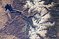
The Continental Divide in the Front Range of the Rocky Mountains of north central Colorado, taken from the International Space Station on October 28, 2008
-
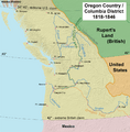
Historically, the Continental Divide was the line between British and US land possession in the disputed Oregon Country.
-
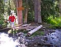
The Parting of the Waters in the Teton Wilderness. One fork flows to the Pacific Ocean while the other flows to the Atlantic.
-
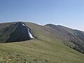
The Continental Divide Trail often remains above the treeline and on the Divide, providing unobstructed views along its route.


See also
 In Spanish: Divisoria continental de América para niños
