
Triple Divide Peak (Montana) facts for kids
Quick facts for kids Triple Divide Peak |
|
|---|---|

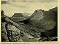
View from Triple Divide Peak
|
|
| Highest point | |
| Elevation | 8,025 ft (2,446 m) |
| Prominence | 180 ft (55 m) |
| Parent peak | Norris Mountain |
| Listing | Mountains in Flathead County Mountains in Glacier County |
| Geography | |

Triple Divide Peak
Location in Montana

Triple Divide Peak
Location in the United States
|
|
| Location | Flathead County, Montana, Glacier County, Montana, U.S. |
| Parent range | Lewis Range |
| Topo map | USGS Mount Stimson, MT |

Triple Divide Peak is a special mountain in the Lewis Range. This range is part of the Rocky Mountains in North America. The peak is located inside Glacier National Park in Montana, USA.
This mountain is unique because it's a "hydrological apex." This means it's a point where water can flow in three different directions. It's where two major continental divides meet: the Continental Divide of the Americas and the Laurentian Divide.
Contents
Where Water Flows from Triple Divide Peak
Imagine rain falling on Triple Divide Peak. Depending on where it lands, that water can end up in three different oceans! It can flow to the Pacific Ocean, the Atlantic Ocean, or the Arctic Ocean.
This makes Triple Divide Peak very special. North America is the only continent with a single spot where water can drain into three different oceans.
Water Flowing to the Pacific Ocean
If rain falls on the southwestern side of the peak, it starts a long journey.
- It first enters Pacific Creek.
- Then it flows into Nyack Creek.
- Next, it joins the Middle Fork of the Flathead River.
- The water continues through the Flathead River and Flathead Lake.
- It then enters the Clark Fork River and Pend Oreille Lake.
- From there, it flows into the Pend Oreille River.
- Finally, it reaches the Columbia River, which empties into the Pacific Ocean near Astoria, Oregon.
Water Flowing to the Arctic Ocean
Water from the northern side of the mountain takes a different path.
- It flows into Hudson Bay Creek.
- Then it drains into Medicine Owl Creek and Red Eagle Creek.
- This water empties into Saint Mary Lake.
- From the lake, it feeds the St. Mary River.
- The St. Mary River flows into the Oldman River.
- It then joins the South Saskatchewan River and the Saskatchewan River.
- This river system leads to the Lake Winnipeg system.
- Finally, the Nelson River drains Lake Winnipeg into Hudson Bay, which is considered part of the Arctic Ocean.
Water Flowing to the Atlantic Ocean
Rain on the southeastern slopes of Triple Divide Peak travels towards the Atlantic.
- It first feeds into Atlantic Creek.
- This creek enters the North Fork of Cut Bank Creek, then Cut Bank Creek itself.
- The water then flows into the Marias River.
- The Marias River joins the mighty Missouri River.
- The Missouri River then connects with the famous Mississippi River.
- The Mississippi River finally empties into the Gulf of Mexico, near New Orleans. The Gulf of Mexico is part of the Atlantic Ocean.
How Triple Divide Peak Was Formed
The Lewis Range, where Triple Divide Peak is located, was formed a very long time ago. About 170 million years ago, a huge slab of very old rock, called Precambrian rock, broke and slid over younger rocks. This event is known as the Lewis Overthrust. It created the amazing mountains we see today.
Images for kids
-
Looking south from Triple Divide Mountain in 1917
.JPG)
See also
 In Spanish: Pico Triple Divide (Montana) para niños
