
Pend Oreille River facts for kids
Quick facts for kids Pend Oreille |
|
|---|---|

Albeni Falls Dam on the Pend Oreille River
|
|

Map of the Pend Oreille River and its main tributaries.
|
|
| Other name(s) | Pend-d'Oreille, Clark Fork |
| Country | United States, Canada |
| State | Washington, Idaho |
| Province | British Columbia |
| City | Sandpoint, ID |
| Physical characteristics | |
| Main source | Lake Pend Oreille Idaho 2,064 ft (629 m) 48°14′20″N 116°36′25″W / 48.23889°N 116.60694°W |
| River mouth | Columbia River British Columbia 1,371 ft (418 m) 49°0′13″N 117°37′13″W / 49.00361°N 117.62028°W |
| Length | 130 mi (210 km) |
| Basin features | |
| Basin size | 25,792 sq mi (66,800 km2) |
| Tributaries |
|
The Pend Oreille River (pronounced POND-ə-RAY) is a river about 130 miles (209 km) long. It flows through northern Idaho and northeastern Washington in the United States. It also goes into southeastern British Columbia in Canada. In Canada, its name is spelled Pend-d'Oreille River.
This river is a tributary of the mighty Columbia River. It drains a beautiful area of the Rocky Mountains near the U.S.-Canada border. Sometimes, people think of the Pend Oreille River as the lower part of the Clark Fork River, which starts in western Montana. The entire area drained by the Pend Oreille and its smaller rivers is huge, covering about 25,792 square miles (66,800 km²). This includes a big part of western Montana and some of British Columbia.
Contents
Where Does the Pend Oreille River Flow?
The Pend Oreille River starts at Lake Pend Oreille in Bonner County, Idaho. This is Idaho's largest lake. The river flows out of the western end of the lake, near the town of Sandpoint. (The Clark Fork River actually flows into the eastern end of Lake Pend Oreille).
From the lake, the Pend Oreille River flows west. It meets the Priest River coming from the north at the town of Priest River. Then, it crosses into southern Pend Oreille County in northeastern Washington, near Newport.
Once in Washington, the river turns north. It flows alongside the eastern side of the Selkirk Mountains for about 50 miles (80 km). It passes through the Colville National Forest, going by towns like Tiger and Metaline Falls. Finally, it crosses the border into southeastern British Columbia. It then loops west for about 15 miles (24 km) before joining the Columbia River from the east. This meeting point is very close to the U.S.-Canada border, about 5 miles (8 km) south of Montrose.
The Pend Oreille River's Watershed
A watershed is an area of land where all the water drains into a single river or lake. The Pend Oreille River watershed is very large, covering about 25,792 square miles (66,800 km²). It spreads across most of western Montana, northern Idaho, and northeastern Washington. It also includes small parts of southern British Columbia.
The southern edge of this watershed forms part of the border between Idaho and Montana. The Pend Oreille River system, including the Clark Fork, is the second longest tributary of the Columbia River. Only the Snake River is longer. It also drains the second largest area, again, after the Snake River.
The eastern side of the Pend Oreille watershed is bordered by the Continental Divide. This is the line that separates rivers flowing to the Pacific Ocean from those flowing to the Atlantic Ocean. The Pend Oreille/Clark Fork river system is special because it cuts right through the Bitterroot Range and Selkirk Range. These are two major mountain chains of the Rocky Mountains.
The main rivers that flow into the Pend Oreille River are the Clark Fork River and the Priest River. Other smaller streams like Cocolalla Creek and Sullivan Creek also join it.
How the Land Was Formed
The Pend Oreille valley has very old rocks, formed over 500 million years ago. These rocks were once the bottom of an ancient sea! Over time, mountains like the Cabinet Mountains were pushed up. The rocks generally get younger as you go downstream (north).
About 200 million years ago, a lot of movement in the Earth's crust created the Idaho Batholith. This later formed the main part of the Bitterroot Range. This mountain range runs along the Clark Fork valley and the Idaho-Montana border. Most scientists agree that the entire Rocky Mountains system was formed around 70 million years ago.
The Ice Age and Giant Floods
During the last Ice Age, a huge glacier called the Cordilleran Ice Sheet moved south. It covered the Lake Pend Oreille and upper Pend Oreille River valley with ice that was thousands of feet thick. This glacier created two giant ice dams.
One very large ice dam blocked the Clark Fork River. This caused water to back up and form a massive lake called Glacial Lake Missoula. This lake stretched over 200 miles (320 km) across western Montana and held a huge amount of water. The other, smaller ice dam blocked the upper Pend Oreille River near Sandpoint.
The pressure from the water and melting ice caused the larger ice dam to break many times. When it broke, massive amounts of water rushed out. These events are known as the Missoula Floods. It was once thought these floods went down the Pend Oreille Valley. However, scientists now believe the water burst through the western side of the valley and rushed towards Spokane.
A Look Back in Time: History of the Pend Oreille River
Native American tribes like the Pend d'Oreilles and Kalispel lived along the Pend Oreille River. They have lived in this area for a very long time, possibly as far back as 11,000 to 12,000 years ago. The name Pend d'Oreille means "earring" or "hang from ears" in French. The Kalispel people were known as "camas people" because they ate the roots of the camas plant.
Early Explorers and Settlers
The first non-Native people to see the Pend Oreille River were French-Canadian fur trappers. They came looking for beaver pelts to trade. These trappers gave the river its French name.
In 1807, a Canadian explorer named David Thompson explored the area. He was trying to find the source of the Columbia River. He set up trading posts, including one called Kullyspell House on Lake Pend Oreille. Thompson tried to travel down the Pend Oreille River to the Columbia, but rapids and waterfalls made it too difficult.
By the 1840s, more Europeans and Americans started moving into the region. Sadly, many Native Americans became sick from diseases like smallpox that they had never encountered before. After many conflicts and agreements, much of the land was given to the new settlers. Many tribes were moved to reservations in northwestern Montana.
Mining and Logging
In the late 1850s, people discovered gold near Metaline Falls on the Pend Oreille River. This brought many new people to the area. While gold mining eventually stopped, lead and zinc mining continued. It was especially important during World War II when these metals were needed for weapons.

Logging was another big industry in the 19th century. The Pend Oreille watershed was full of trees. However, moving the logs downriver was a challenge because the river flows north, which was the opposite direction needed to get logs to mills further south.
Steamboats were introduced to help. The first steamboat, The Bertha, was built in 1887. These boats carried passengers and ore, and they also towed log rafts. It was tricky to navigate the river, especially past the Box Canyon rapids. Eventually, railroads like the Idaho & Washington Northern Railroad took over, and logs were transported by train instead of steamboat.
Settling in the Pend Oreille River valley was not easy for early pioneers. There wasn't much flat land for farming, and often the river was surrounded by steep cliffs or dense forests. Still, some towns grew, like Newport, Ione, and Metaline Falls. Today, Sandpoint, near Lake Pend Oreille, is the largest city close to the river.
Dams on the Pend Oreille River
There are five large hydroelectric dams on the Pend Oreille River. These dams use the power of the flowing water to create electricity.
- Waneta Dam and Seven Mile Dam are in Canada.
- Boundary Dam, Box Canyon Dam, and Albeni Falls Dam are in the United States.
The Boundary Dam is the largest, producing a lot of electricity. The Albeni Falls Dam helps control the water level of Lake Pend Oreille. This helps prevent floods in the summer and ensures enough water flows in dry winters. None of these dams have ways for fish to pass through or for boats to travel past them.
Other dams further upstream on the Clark Fork and Flathead rivers also generate power and help control the water flowing into Lake Pend Oreille.
In the 1920s, there was an idea to dig a long canal to bring water from the Pend Oreille River to irrigate farms in eastern Washington. But these plans were changed when the Grand Coulee Dam was built on the Columbia River instead.
Protecting the River
Efforts are being made to help the river's environment. For example, to make up for the impact of the Boundary Dam, a smaller dam called 'Mill Pond Dam' on Sullivan Creek was removed in 2017. This project helped restore the natural flow of Sullivan Creek. Now, native trout species can benefit from the improved habitat.
Fun on the River
The Pend Oreille River is a great place for outdoor activities! Many people enjoy boating and fishing here.
There's also the Pend Oreille River Trail, which is about 70 miles (113 km) long. It goes from the Idaho/Washington border all the way to Boundary Dam near Canada. You can find maps for this trail on the Pend Oreille County website.
Images for kids
-
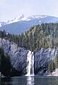
PeeWee Falls and the Pend Oreille River near Boundary Dam
-
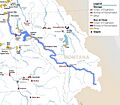
Map showing dams in the Pend Oreille River watershed (Clark Fork-Lake Pend Oreille-Pend Oreille system highlighted in blue)


See also
 In Spanish: Río Pend Oreille para niños
