
Selkirk Mountains facts for kids
Quick facts for kids Selkirk Mountains |
|
|---|---|

At the Rogers Pass by John A. Fraser, 1886
|
|
| Highest point | |
| Peak | Mount Sir Sandford |
| Elevation | 3,519 m (11,545 ft) |
| Dimensions | |
| Length | 525 km (326 mi) NS |
| Width | 175 km (109 mi) EW |
| Geography | |

Location map of the Selkirk Mountains
|
|
| Countries | Canada and United States |
| Range coordinates | 49°57′N 117°23′W / 49.95°N 117.38°W |
| Parent range | Columbia Mountains |
| Geology | |
| Type of rock | Metamorphic rock |
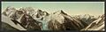
The Selkirk Mountains are a large mountain range found in parts of Idaho, Washington, and British Columbia in Canada. They are part of a bigger group of mountains called the Columbia Mountains. The Selkirks stretch about 320 kilometers (200 miles) north from near Spokane to Kinbasket Lake.
The Columbia River and its lakes form the western and northern edges of the range. To the east, the Purcell Trench separates the Selkirks from other mountains. The Selkirks are much older than the Rocky Mountains. Other nearby ranges like the Monashee and Purcell Mountains are also part of the Columbia Mountains. You can explore the southern Selkirks by driving the scenic International Selkirk Loop. These mountains were named after Thomas Douglas, 5th Earl of Selkirk.
Contents
Exploring the Selkirk Mountains: A Look at Their History

In 1857, people found gold in the Selkirk Mountains. Other valuable minerals like coal, copper, silver, and zinc were also discovered.
Building the Canadian Pacific Railway
The Selkirks were a big challenge for building the Canadian Pacific Railway. This railway was important for connecting Canada from east to west. In 1881–1882, a person named A.B. Rogers found a mountain pass through the mountains. This pass is now called Rogers Pass.
Because of the railway, two of Canada's first national parks were created here. These are Mount Revelstoke National Park and Glacier National Park. They are located right in the heart of the Selkirks. Before the Trans-Canada Highway was built through Rogers Pass, cars had to drive a much longer way around the northern end of the Selkirks.
Wildlife of the Selkirk Mountains
The Selkirk Mountains are home to many different animals. Some of these animals live in protected areas like Washington's Salmo-Priest Wilderness. You can find animals such as mule deer and white-tailed deer here.
Mammals and Birds in the Selkirks
Other large mammals that live in these mountains include elk, black bears, cougars, and gray wolves. You might also see smaller animals like bobcats, red fox, porcupine, badgers, coyote, and martens.
The mountains are also home to impressive birds. These include bald eagles, golden eagles, osprey, and great blue heron. Bighorn sheep and mountain goats also live in the rocky areas. In recent years, grizzly bears have become more common in this region.
The South Selkirk Mountain Caribou Herd
The southern part of the Selkirk Mountains was once home to a special group of caribou. These were the last naturally living caribou in the contiguous United States. This group, called the South Selkirk mountain caribou, moved between northern Idaho, eastern Washington, and British Columbia, Canada.
These caribou are a type of woodland mountain caribou. They are one of the most endangered mammals in the world. In 2009, there were about 50 caribou in the herd. By April 2018, only three were left. In January 2019, scientists announced that the last female caribou in this herd was moved to a special pen. This was done to try and help save this very endangered group of animals.
Parts of the Selkirk Mountains
The Selkirk Mountains are made up of many smaller mountain ranges. Here are some of them:
- Asulkan Range
- Battle Range
- Big Bend Ranges
- Adamant Range
- Sir Sandford Range
- Windy Range
- Bishops Range
- Bonnington Range
- Clachnacudainn Range
- Dawson Range
- Dishman Hills
- Duncan Ranges
- Badshot Range
- Goat Range
- Hermit Range
- Holiday Hills
- Huckleberry Range
- Kokanee Range
- Lardeau Range
- Nelson Range
- Purity Range
- Sir Donald Range
- Valhalla Ranges
- Ruby Range
- Valkyr Range
- Norns Range
Images for kids
-
Mt. Fox and Mt. Dawson from Asulkan Pass, British Columbia, c. 1902
See also
 In Spanish: Montañas Selkirk para niños
