Kinbasket Lake facts for kids
Quick facts for kids Kinbasket Lake |
|
|---|---|

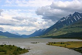
Kinbasket Lake seen from its northern tip, near Valemount
|
|
| Location | British Columbia, from NW to SE of Mica Creek |
| Coordinates | 52°08′N 118°27′W / 52.133°N 118.450°W |
| Type | reservoir |
| Primary inflows | Columbia River, Canoe River |
| Primary outflows | Columbia River |
| Basin countries | Canada |
Kinbasket Lake is a large lake in the beautiful province of British Columbia, Canada. It is not a natural lake, but a reservoir. This means it was created by people building a big wall, called a dam, across a river.
Kinbasket Lake is located in the southeastern part of British Columbia. It sits north of the city of Revelstoke and the town of Golden. The lake is formed by the Columbia River, one of North America's largest rivers.
How Kinbasket Lake Was Made
Kinbasket Lake was created when the Mica Dam was built. This huge dam was finished in 1973. When the dam was completed, it held back the water from the Columbia River. This caused the river valley to fill up, forming the large lake we see today.
The lake has two main parts, often called "reaches." The Columbia Reach is the southern part. The Canoe Reach is the northern part. These names come from the river valleys that were flooded by the dam. The northern end of the lake almost reaches the town of Valemount. This part was formed by the flooding of the Canoe River. The southern end stretches upstream along the Columbia River towards the city of Golden.
The Lake's Name
The original, smaller Kinbasket Lake was named in 1866. It was named after Kinbasket, a chief of the Shuswap people. The Shuswap are an Indigenous group who have lived in this area for a very long time.
When the modern, much larger lake was created in 1973, it was first called McNaughton Lake. This name honored Andrew McNaughton, a famous Canadian general and diplomat. However, in 1980, the name was changed back to Kinbasket Lake. This change honored the original Indigenous name and its history.
Towns Under the Water
When Kinbasket Lake was created, several small communities were covered by the rising water. This area was known as the Big Bend Country. It was a subregion of the Columbia Country. Some of the towns that were flooded include:
- Mica
- Big Bend
- Downie
- Boat Encampment
- La Porte
- Beavermouth
These towns are now underwater, a part of the lake's history.
 | Isaac Myers |
 | D. Hamilton Jackson |
 | A. Philip Randolph |


