
Lake Pend Oreille facts for kids
Quick facts for kids Lake Pend Oreille |
|
|---|---|

Aerial view in 1993
|
|

Lake Pend Oreille
Location in Idaho

Lake Pend Oreille
Location in the United States
|
|
| Location | Bonner / Kootenai counties, Idaho, U.S. |
| Coordinates | 48°10′0″N 116°20′0″W / 48.16667°N 116.33333°W |
| Primary inflows | Clark Fork River, Pack River, Trestle Creek |
| Primary outflows | Pend Oreille River, Spokane Valley–Rathdrum Prairie Aquifer |
| Basin countries | United States |
| Max. length | 69 kilometres (43 mi) |
| Surface area | 380 km2 (150 sq mi) |
| Average depth | 142 m (466 ft) |
| Max. depth | 351 m (1,152 ft) |
| Water volume | 53.96 km3 (12.95 cu mi) |
| Surface elevation | 628 metres (2,060 ft) |
| Trenches | Purcell |
| Settlements | Sandpoint, Bayview |
Lake Pend Oreille (pronounced POND-ə-RAY) is a huge lake in northern Idaho. It is the largest lake in the state of Idaho. It is also the 38th-largest lake in the United States by its surface area.
This amazing lake is about 69 kilometers (43 miles) long. In some places, it is 351 meters (1,152 feet) deep. This makes it the fifth-deepest lake in the entire country! The lake gets its water from the Clark Fork River and the Pack River. Its water then flows into the Pend Oreille River. Some water also goes underground into the Spokane Valley–Rathdrum Prairie Aquifer.
The lake is surrounded by beautiful national forests. There are also a few small towns nearby. The biggest town on the lake is Sandpoint. Most of the lake's shoreline does not have many people living there. Almost all of the lake is in Bonner County. Only the very southern tip is in Kootenai County. This southern tip is home to Farragut State Park. This park used to be a big naval training base during World War II. A small part of it is still used by the U.S. Navy for special underwater research.
Contents
Nature Around Lake Pend Oreille
The forests around Lake Pend Oreille are full of different trees. You can find ponderosa pine, Douglas fir, and red cedar. There are also poplar, quaking aspen, hemlock, paper birch, and western larch trees.
Animals Living Near the Lake
Many animals call this area home. You might see white-tailed deer, elk, and moose. There are also gray wolves, black bears, and even grizzly bears. Smaller animals like mice, squirrels, and chipmunks live here too. You might also spot coyotes, mountain goats, cougars, and bobcats.
The sky above the lake is busy with many birds. Look for bald eagles, wild turkeys, and osprey. You can also see owls, hummingbirds, hawks, and woodpeckers. Ducks and the bright mountain bluebird also live here. Many types of water birds stop at the lake during their long journeys.
History of Lake Pend Oreille
Lake Pend Oreille was formed a very long time ago during the ice age. Giant sheets of ice, called glaciers, carved out the land. The lake sits at the end of a long valley called the Purcell Trench. This valley was made by glaciers moving south from Canada.
Scientists believe that the eastern side of the lake helped to hold back the ancient Missoula Floods. These were huge floods that happened when ice dams broke. A dam at Albeni Falls makes the lake a little bigger today. This dam is 27 meters (90 feet) high. The U.S. Army Corps of Engineers manages it. Lake Pend Oreille is one of the five deepest lakes in the United States. The others are Crater Lake, Lake Tahoe, Lake Chelan, and Lake Superior.
Native Peoples and Explorers
The land around Lake Pend Oreille has long been the home of the Kalispel Indian people. In 1809, an explorer named David Thompson set up a trading post here. He was part of the North West Company. A fur trader with Thompson is thought to have given the lake its name. "Pend Oreille" is a French phrase meaning "ear-hanging" or "pendant." This name came from the ear ornaments that the Kalispel tribe wore. Also, if you look at the lake on a map, it actually looks a bit like a human ear!
,_Sea_Jet,_undergoes_sea_trials_on_Lake_Pend_Oreille_at_the_Naval_Surface_Warfare_Center_Carderock_Division,_Acoustic_Research_Detachment_in_Bayview,_Idah.jpg)
During World War II, the southern end of the lake became very important. It was the site of the Farragut Naval Training Station. This was the second-largest naval training base in the world. At that time, it was the biggest "city" in Idaho! It was built after the Japanese attack on Pearl Harbor. Today, this training station is Farragut State Park.
The Navy still uses a part of the lake for special research. They test large submarine models here. This is done at the Pend Oreille Calibration Station. The lake's great depth helps them test sonar equipment. The deep water acts like the open ocean. Also, the lake is very quiet, which helps with accurate testing. Foreign governments cannot easily listen in on these tests in the lake, unlike in international waters.
In 1967, the former Farragut Naval Training Station hosted a big event. It was the 12th World Scout Jamboree. This event happened from August 1st to 8th. These dates were special because they marked 60 years since the first scout camp. That first camp was held by Sir Robert Baden Powell in England.
Towns and Scenery Around the Lake

Several towns are located right next to Lake Pend Oreille:
You can enjoy amazing views of the lake from the Pend Oreille Scenic Byway. This is State Highway 200 along the north shore. US 95 crosses the lake on a long bridge. Much of the shoreline is surrounded by mountains. To the east are the Green Monarchs. The Cabinet Mountains are to the north. To the southwest are the Coeur d'Alene Mountains. And to the northwest are the Selkirk Mountains.
Aquatic Invasive Species
Lake Pend Oreille is home to some invasive species. These are plants or animals that are not native to the lake. They can sometimes cause problems for the natural environment. Some of these species include:
- Eurasian watermilfoil (a plant)
- Walleye (a type of fish, also called Yellow Pike)
- Lake Trout (a type of fish)
Fish in the Lake

Lake Pend Oreille is a great place for fishing! It has many different kinds of fish. You can find rainbow trout, lake trout, and bull trout. There are also cutthroat trout, brown trout, and cutbow (a mix of cutthroat and rainbow trout). Other fish include perch, black crappie, bluegill, largemouth bass, and smallmouth bass. You might also catch whitefish, walleye, northern pike, northern pikeminnow, and kokanee salmon.
A very famous fish was caught in Lake Pend Oreille in 1947. It was a huge gerrard rainbow trout (also known as a kamloops rainbow). This fish weighed an amazing 37 pounds! It still holds the state record for that type of fish.
Images for kids
-
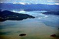
Aerial view in 1993
-
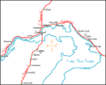
Highways and towns on the northern end of Lake Pend Oreille.
-
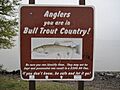
A sign in Sandpoint for people fishing, about protecting bull trout.
-
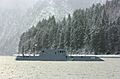
The Advanced Electric Ship Demonstrator (AESD) being tested on Lake Pend Oreille.
See also
 In Spanish: Lago Pend Oreille para niños
