Kootenai County, Idaho facts for kids
Quick facts for kids
Kootenai County
|
||
|---|---|---|

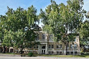
Kootenai County Courthouse
|
||
|
||

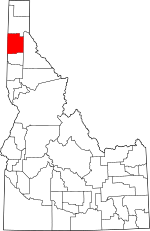
Location within the U.S. state of Idaho
|
||
 Idaho's location within the U.S. |
||
| Country | ||
| State | ||
| Founded | December 22, 1864 | |
| Named for | Kootenai tribe | |
| Seat | Coeur d'Alene | |
| Largest city | Coeur d'Alene | |
| Area | ||
| • Total | 1,316 sq mi (3,410 km2) | |
| • Land | 1,244 sq mi (3,220 km2) | |
| • Water | 71 sq mi (180 km2) 5.4% | |
| Population
(2020)
|
||
| • Total | 171,362 | |
| • Estimate
(2023)
|
185,010 |
|
| • Density | 130.21/sq mi (50.276/km2) | |
| Time zone | UTC−8 (Pacific) | |
| • Summer (DST) | UTC−7 (PDT) | |
| Congressional district | 1st | |
Kootenai County (pronounced KOOT-nee) is a county in the state of Idaho. It is located in the northern part of Idaho, often called the Idaho Panhandle. In 2020, about 171,362 people lived here. This makes it the third most populated county in Idaho. It is also the largest county in North Idaho. The main city and county seat is Coeur d'Alene. Kootenai County was created in 1864. It was named after the Kootenai tribe.
Contents
History of Kootenai County
Early Native American Life
The area around Lake Coeur d'Alene is named after the local Coeur d'Alene Native Americans. French fur traders gave them this name. The tribe first lived in three groups around the lake and the Coeur d'Alene River.
First Europeans Arrive
Canadian fur traders came to this region in 1809. This was the first time the tribe met Europeans. Christian missionaries followed later. The first Christian meeting happened on December 2, 1842. It was led by Father Nicolas Pointe. This meeting took place where Coeur d'Alene Lake meets the Spokane River.
Missions and Roads
The St. Joseph mission was first built in 1844. It was located northwest of St. Maries. Later, it moved to Cataldo in 1846 and was renamed Mission of the Sacred Heart. The church building was finished by 1855. It is the oldest building in Idaho. The mission's main office moved to DeSmet in 1877.
The Mullan Road was built through the area in 1859. This road first ran along the south side of Coeur d'Alene Lake. A new route on the north side of the lake started in 1861. Mullan's workers celebrated Independence Day in 1861 at Fourth of July Canyon. This canyon is east of Coeur d'Alene.
Kootenai County Begins
The Idaho Territorial Legislature created Kootenai County on December 22, 1864. But, a county government was not set up right away. This was because not many people lived there yet. In 1864, only 81 people lived in Kootenai County.
Rathdrum was the first town to be settled, starting in 1861. It became a stop for stagecoaches. Later, Rathdrum became the county seat. By 1870, only 31 people were reported in the Kootenai District. Post Falls was settled in 1871. Camp Coeur d'Alene was set up in 1878. This camp became a fort in 1879. The town of Coeur d'Alene grew around this fort. Other towns like Dalton Gardens, Hayden, and Hayden Lake were also settled around this time.
County Government Forms
After almost 17 years, Kootenai County finally set up its government on July 9, 1881. The county became more important when the Northern Pacific Railway reached Rathdrum in 1882. Also, gold was found on the Coeur d'Alene River in 1883. This led to existing towns growing and new ones starting. Settlements like Athol (1882) and Harrison (1890) began along the railroad.
Growth of Cities
More people moving to the area led to the growth of cities. In 1899, Harrison was the first city in the county to become officially incorporated. Coeur d'Alene followed in 1906, Spirit Lake in 1908, and Athol in 1909. Rathdrum, Post Falls, and Worley became cities before 1920.
Later, Clarksville, Hayden Lake, Huetter, State Line, and Eddiville all became cities in 1947. Hayden, Dalton Gardens, and Fernan Lake became cities after 1950. Eddiville and Clarksville were later no longer considered cities before 1970.
Changing County Borders
When the Coeur d'Alene Mission was built, both the United States and Britain claimed the land of Kootenai County. Over time, the county's borders changed many times. It was part of different territories and counties.
In 1907, Bonner County was created from part of Kootenai County. In 1915, Benewah County was also created. These changes gave Kootenai County its current shape.
Geography of Kootenai County
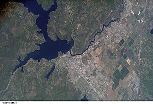
Kootenai County covers about 1,316 square miles. About 1,244 square miles is land. The other 71 square miles (5.4%) is water. The county's water areas include Lake Coeur d'Alene and the southern part of Lake Pend Oreille. Kootenai County is part of the Inland Empire region.
Neighboring Counties
- Bonner County – to the north
- Shoshone County – to the east
- Benewah County – to the south
- Spokane County, Washington – to the west
Protected Natural Areas
- Coeur d'Alene National Forest (part)
- Kaniksu National Forest (part)
Main Roads
 I-90
I-90 I-90 Business Loop
 US 95
US 95 SH 3
SH 3 SH 41
SH 41 SH 53
SH 53 SH 54
SH 54 SH 58
SH 58 SH 97
SH 97
Public Transport
- Citylink
- Jefferson Lines
Population Information
| Historical population | |||
|---|---|---|---|
| Census | Pop. | %± | |
| 1870 | 31 | — | |
| 1880 | 518 | 1,571.0% | |
| 1890 | 4,108 | 693.1% | |
| 1900 | 10,216 | 148.7% | |
| 1910 | 22,747 | 122.7% | |
| 1920 | 17,878 | −21.4% | |
| 1930 | 19,469 | 8.9% | |
| 1940 | 22,283 | 14.5% | |
| 1950 | 24,947 | 12.0% | |
| 1960 | 29,556 | 18.5% | |
| 1970 | 35,332 | 19.5% | |
| 1980 | 59,770 | 69.2% | |
| 1990 | 69,795 | 16.8% | |
| 2000 | 108,685 | 55.7% | |
| 2010 | 138,494 | 27.4% | |
| 2020 | 171,362 | 23.7% | |
| 2023 (est.) | 185,010 | 33.6% | |
| U.S. Decennial Census 1790–1960 1900–1990 1990–2000 2010–2020 |
|||
In 2020, Kootenai County had 171,362 people. There were 71,309 households and 74,736 housing units.
In 2010, there were 138,494 people living in the county. The population density was about 111 people per square mile. Most people (94.5%) were white. About 1.3% were American Indian. People of Hispanic or Latino origin made up 3.8% of the population.
The average age of people in the county was 38.9 years. About 32.8% of households had children under 18 living with them.
Communities in Kootenai County
Cities
Census-Designated Places
Other Communities
Education in Kootenai County
Here are some of the school districts in Kootenai County:
- Coeur d'Alene School District 271
- Kellogg Joint School District 391
- Kootenai Joint School District 274
- Lakeland Joint School District 272
- Plummer-Worley Joint School District 44
- Post Falls School District 273
The county is also home to North Idaho College. This college serves students from Kootenai County.
See also
 In Spanish: Condado de Kootenai para niños
 | Leon Lynch |
 | Milton P. Webster |
 | Ferdinand Smith |


