Post Falls, Idaho facts for kids
Quick facts for kids
Post Falls
|
|
|---|---|

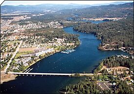
Downtown Post Falls along the Spokane River
|
|

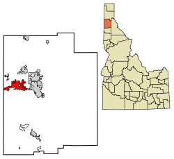
Location of Post Falls in Kootenai County, Idaho
|
|
| Country | United States |
| State | Idaho |
| County | Kootenai |
| Founded | June 1, 1871 |
| Incorporated | 1891 |
| Government | |
| • Type | City Council (6) & Mayor elected to four-year terms |
| Area | |
| • City | 15.17 sq mi (39.29 km2) |
| • Land | 15.14 sq mi (39.22 km2) |
| • Water | 0.03 sq mi (0.07 km2) |
| Elevation | 2,202 ft (671 m) |
| Population
(2020)
|
|
| • City | 38,485 |
| • Estimate
(2022)
|
44,194 |
| • Rank | US: 740th ID: 9th |
| • Density | 2,730/sq mi (1,055/km2) |
| • Urban | 121,831 (US: 272nd) |
| • Metro | 183,578 (US: 240th) |
| • Combined | 781,497 (US: 70th) |
| Time zone | UTC–8 (Pacific (PST)) |
| • Summer (DST) | UTC–7 (PDT) |
| ZIP Codes |
83854, 83877
|
| Area code(s) | 208 and 986 |
| FIPS code | 16-64810 |
| GNIS feature ID | 2411475 |
Post Falls is a city in Kootenai County, Idaho, USA. It's often called the 'gateway' to Northern Idaho. The city is located right off Interstate 90, west of Coeur d'Alene and east of Spokane, Washington.
In 2020, about 38,485 people lived there, making it Idaho's ninth-largest city. It's also the second biggest city in North Idaho, after Coeur d'Alene.
Contents
The History of Post Falls
Post Falls is named after a man named Frederick Post. He was an immigrant from Germany. In 1871, he built a lumber mill along the Spokane River.
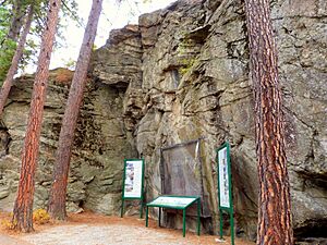
He bought the land for his mill from Andrew Seltice, who was the Chief of the Coeur d'Alene Tribe. This important land purchase is remembered with a special drawing on a granite cliff. You can see this drawing at Treaty Rock Park.
Where is Post Falls?
Post Falls is located at these coordinates: 47°42′43″N 116°56′53″W / 47.712°N 116.948°W.
The city covers about 14.11 square miles (36.54 square kilometers). Most of this area is land, with only a small part being water.
Post Falls sits on the Rathdrum Prairie, right near the border between Washington and Idaho. To the east, you'll find Coeur d’Alene. To the west are Stateline and the state of Washington. The Spokane River flows along the city's southern edge.
Post Falls is about 20 miles (32 km) east of Spokane. It's also about 100 miles (160 km) south of the border with Canada. The city is about 2,182 feet (665 meters) above sea level.
Post Falls Climate and Weather
Post Falls has a Warm-summer mediterranean climate (Csb). This means it has four very clear seasons. Summers are warm and dry, while winters are cool and wet.
| Climate data for Post Falls, Idaho | |||||||||||||
|---|---|---|---|---|---|---|---|---|---|---|---|---|---|
| Month | Jan | Feb | Mar | Apr | May | Jun | Jul | Aug | Sep | Oct | Nov | Dec | Year |
| Record high °F (°C) | 60 (16) |
62 (17) |
73 (23) |
94 (34) |
98 (37) |
102 (39) |
108 (42) |
109 (43) |
102 (39) |
87 (31) |
71 (22) |
60 (16) |
109 (43) |
| Mean daily maximum °F (°C) | 36 (2) |
40 (4) |
49 (9) |
56 (13) |
65 (18) |
72 (22) |
82 (28) |
82 (28) |
73 (23) |
58 (14) |
44 (7) |
34 (1) |
58 (14) |
| Mean daily minimum °F (°C) | 26 (−3) |
27 (−3) |
31 (−1) |
37 (3) |
44 (7) |
51 (11) |
56 (13) |
56 (13) |
48 (9) |
38 (3) |
32 (0) |
25 (−4) |
39 (4) |
| Record low °F (°C) | −30 (−34) |
−29 (−34) |
−13 (−25) |
5 (−15) |
21 (−6) |
28 (−2) |
36 (2) |
32 (0) |
17 (−8) |
2 (−17) |
−13 (−25) |
−26 (−32) |
−30 (−34) |
| Average precipitation inches (mm) | 3.18 (81) |
2.20 (56) |
2.32 (59) |
1.88 (48) |
2.16 (55) |
1.98 (50) |
0.94 (24) |
0.87 (22) |
1.01 (26) |
1.95 (50) |
3.72 (94) |
3.52 (89) |
25.73 (654) |
| Average snowfall inches (cm) | 17.1 (43) |
8.8 (22) |
5.6 (14) |
1.0 (2.5) |
0.4 (1.0) |
0.1 (0.25) |
0.0 (0.0) |
0.0 (0.0) |
0.0 (0.0) |
0.7 (1.8) |
7.0 (18) |
18.6 (47) |
59.3 (151) |
Schools and Education
The public schools in Post Falls are managed by the Post Falls School District #273. Here are some of the schools in the city:
- Classical Christian Academy
- Frederick Post Kindergarten
- Greensferry Elementary
- Genesis Prep Academy
- Mullan Trail Elementary
- Ponderosa Elementary
- Prairie View Elementary
- Seltice Elementary
- Treaty Rock Elementary
- West Ridge Elementary
- Post Falls Middle School
- Immaculate Conception Academy
- River City Middle School
- Post Falls High School
- New Vision Alternative High School
- North Idaho College Workforce Training Center
- St. Dominic School
- Pinegrove Academy
- Elevate Academy North (Charter)
Population and People
| Historical population | |||
|---|---|---|---|
| Census | Pop. | %± | |
| 1900 | 287 | — | |
| 1910 | 658 | 129.3% | |
| 1920 | 576 | −12.5% | |
| 1930 | 509 | −11.6% | |
| 1940 | 843 | 65.6% | |
| 1950 | 1,069 | 26.8% | |
| 1960 | 1,983 | 85.5% | |
| 1970 | 2,371 | 19.6% | |
| 1980 | 5,736 | 141.9% | |
| 1990 | 7,349 | 28.1% | |
| 2000 | 17,247 | 134.7% | |
| 2010 | 27,574 | 59.9% | |
| 2020 | 38,485 | 39.6% | |
| 2022 (est.) | 44,194 | 60.3% | |
| U.S. Decennial Census 2020 Census |
|||
In 2022, the average income for a household in Post Falls was about $71,042 per year.
What the 2020 Census Showed
The census of 2020 counted 38,485 people living in Post Falls. There were 14,430 households in the city.
What the 2010 Census Showed
The census of 2010 found 27,574 people living in Post Falls. There were 10,263 households and 7,396 families.
Most people in the city (94.0%) were White. About 4.6% of the population was Hispanic or Latino.
In 40.2% of households, there were children under 18 years old. About 53.7% of households were married couples living together. The average household had 2.68 people.
The average age in the city was 33 years old. About 29% of residents were under 18. About 11.3% were 65 years or older.
Economy and Jobs
Post Falls is a popular place for tourism and retirement. This is because it's close to many lakes, rivers, and mountains. More and more shops, restaurants, and entertainment businesses are opening in the city.
Historically, Kootenai County relied a lot on the timber industry (lumber). However, this is changing. Now, there are more different types of manufacturing jobs. Local groups like Jobs Plus, Inc. have helped bring many small and medium-sized companies to the area.
Today, manufacturing jobs are mainly in electronics, lumber, and furniture. For example, Flexcel, Inc., a big furniture maker, moved to North Idaho years ago and employs 350 people. Jobs Plus, Inc. also helped bring Center Partners, a call center, and Buck Knives, a knife manufacturer, to the city. These companies employ hundreds of people.
Other important businesses have also opened in Post Falls. A private surgical hospital was built in 2004. Sysco foods opened a distribution plant in 2005. In 2007, Cabelas opened a large retail store. More recently, ALK Source Materials/Biopol, a Danish pharmaceutical company, opened here. A second Walmart store and a Lowe's Home Improvement store have also been built.
Ground Force Manufacturing, which makes construction equipment, expanded its space in 2009. This helped them meet the high demand for their mining products worldwide. The Idaho Department of Labor also built its new regional office in Post Falls.
Main Employers in Post Falls
Here are some of the largest employers in Post Falls, based on a 2022 report:
| # | Employer | Type of Business | # of Employees | Percentage |
|---|---|---|---|---|
| 1 | Post Falls School District | Public Education | 700–799 | 3.9%–4.5% |
| 2 | Pleasant View Surgery Center | Healthcare | 200–299 | 1.7%–2.2% |
| 3 | Rehabilitation Hospital of the Northwest | Healthcare | 200–299 | 1.1%–1.7% |
| 4 | North Idaho Day Surgery | Healthcare | 200–299 | 1.1%–1.7% |
| 5 | Buck Knives | Manufacturing | 200–299 | 1.1%–1.7% |
| 6 | City of Post Falls | Government | 200–299 | 1.1%–1.7% |
| 7 | Walmart | Retail | 200–299 | 1.1%–1.7% |
| 8 | Tedder Industries | Manufacturing | 150–199 | 0.8%–1.1% |
| 9 | Red Lion Hotels | Hotel | 100–149 | 0.6%–0.8% |
| 10 | All Wall Contracting | Construction | 100–199 | 0.6%–0.8% |
| — | Total employers | — | 17,884 | 13.1%–17.9% |
Getting Around Post Falls
The main highway that goes through Post Falls is Interstate 90. This highway runs east and west across the northern United States.
About 2 miles (3 km) east of Post Falls, I-90 connects with State Highway 41. Highway 41 goes 8 miles (13 km) north to Rathdrum. Post Falls is also about 7 miles (11 km) west of U.S. Route 95. This is Idaho's main north-south highway, and it goes all the way into Canada.
If you need to fly, the closest airport with passenger service is Spokane International Airport. This airport is located west of Spokane. For train travel, Amtrak passenger service is available in Spokane and Sandpoint. You can also find bus and taxi services in the Post Falls area.
See also
 In Spanish: Post Falls para niños
 | John T. Biggers |
 | Thomas Blackshear |
 | Mark Bradford |
 | Beverly Buchanan |


