Idaho panhandle facts for kids
Quick facts for kids
Idaho panhandle
|
|
|---|---|

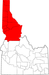
Red: The ten counties of the Idaho panhandle
|
|
| Country | United States |
| State | Idaho |
| Largest city | Coeur d'Alene |
| Area | |
| • Total | 21,012.64 sq mi (54,422.5 km2) |
| Population
(2010)
|
317,751 |
The Idaho Panhandle is a unique part of the U.S. state of Idaho. People often call it North Idaho or Northern Idaho. It's like a narrow "handle" at the top of the state. This area stretches north between the state of Washington and Montana. It also shares a border with British Columbia in Canada!
The Panhandle includes 10 counties: Benewah, Bonner, Boundary, Clearwater, Idaho, Kootenai, Latah, Lewis, Nez Perce, and Shoshone. This region, along with parts of eastern Washington, forms an area called the Inland Northwest.
Contents
Cities and Towns in the Panhandle
Coeur d'Alene is the biggest city in the Idaho Panhandle. It's a busy place with lots to see and do. Just about 30 miles (48 km) to the west is Spokane, Washington. Spokane's airport is the main one for people traveling to and from this region.
Other important cities here include Lewiston, Moscow, Post Falls, Hayden, and Sandpoint. Smaller towns like St. Maries and Bonners Ferry are also part of the Panhandle. East of Coeur d'Alene, you'll find the Silver Valley, known for its mining history.
The Idaho Panhandle covers about 21,013 square miles (54,423 km²). That's about a quarter of Idaho's total land! In 2010, about 317,751 people lived here.
Border Crossings
The town of Bonners Ferry has two places where you can cross the border into Canada. The Porthill-Rykerts Border Crossing connects to Creston, British Columbia. The Eastport–Kingsgate Border Crossing connects to Yahk, British Columbia.
History of the Panhandle
The eastern border of Idaho follows the Bitterroot Range of mountains. This is why the northern part of the state is so narrow, forming the "panhandle" shape. Traveling through this area used to be very difficult because of the mountains. However, major improvements to roads like U.S. Route 95 made it much easier to get around. These improvements happened between the 1960s and 1990s.
Fun Things to Do
The Idaho Panhandle offers many exciting places to visit and activities to enjoy:
- Bird Aviation Museum and Invention Center
- Clearwater River
- Idaho Panhandle National Forest
- Kootenai River
- Lake Coeur d'Alene
- Lake Pend Oreille
- Lookout Pass Ski and Recreation Area
- North Idaho College
- Priest Lake
- Schweitzer Mountain
- Snake River
- Silver Mountain
- Silverwood Theme Park
- University of Idaho
Nature and Weather
Most of the Idaho Panhandle uses Pacific Time. This is different from the rest of Idaho to the south, which uses Mountain Time. This time zone difference exists because cities like Coeur d'Alene are very connected to Spokane, Washington, which is in the Pacific Time Zone. Also, many towns near the border, like Moscow and Lewiston, are closely linked to cities in Washington.

Farming and Forests
The North Idaho region is well-known for its forests and lumber. Many trees are grown here, and there are 12 lumber mills that produce wood. Farmers also grow grass seeds and hops, which are used to make beer. There are nine small breweries in the area, showing how important hops are. You can also find many cattle ranches here.
In the Palouse region, which is part of the Panhandle, important crops include wheat, lentils, peas, and canola.
Native American Lands
The Idaho Panhandle is home to several Indian reservations. These are lands set aside for Native American tribes.
Major Communities
Here are some of the main communities in the Idaho Panhandle:
- Bonners Ferry
- Coeur d'Alene
- Dalton Gardens
- Grangeville
- Hayden
- Kellogg
- Lewiston
- Lenore
- Moscow
- Orofino
- Post Falls
- Rathdrum
- Sandpoint
- St. Maries
- Wallace
See also
 In Spanish: Mango de Idaho para niños
 | Misty Copeland |
 | Raven Wilkinson |
 | Debra Austin |
 | Aesha Ash |

