Lewis County, Idaho facts for kids
Quick facts for kids
Lewis County
|
||
|---|---|---|

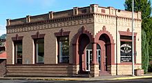
State Bank of Kamiah
|
||
|
||

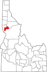
Location within the U.S. state of Idaho
|
||
 Idaho's location within the U.S. |
||
| Country | ||
| State | ||
| Founded | March 3, 1911 | |
| Named for | Meriwether Lewis | |
| Seat | Nezperce | |
| Largest city | Kamiah | |
| Area | ||
| • Total | 480 sq mi (1,200 km2) | |
| • Land | 479 sq mi (1,240 km2) | |
| • Water | 0.9 sq mi (2 km2) 0.2% | |
| Population
(2020)
|
||
| • Total | 3,533 | |
| • Density | 7.36/sq mi (2.842/km2) | |
| Time zone | UTC−8 (Pacific) | |
| • Summer (DST) | UTC−7 (PDT) | |
| Congressional district | 1st | |
Lewis County is a county in the north central part of Idaho. It was named after the famous explorer Meriwether Lewis. In 2020, about 3,533 people lived here. This makes it one of the least populated counties in Idaho.
The main town, or county seat, is Nezperce. The biggest city is Kamiah. Lewis County was created in 1911 from parts of Nez Perce County. A large part of the county is inside the Nez Perce Indian Reservation. However, only a small number of people living in the county are Native Americans. In 1895, the U.S. government opened the reservation land for new settlers.
Contents
History
Early People and Explorers
People have lived in Idaho for a very long time, possibly as far back as 14,000 years ago. The first people in the area were hunters of large animals. The Nez Perce people have lived in Idaho's Camas Prairie for over 8,000 years. They developed better hunting tools and created art.
The Nez Perce got horses from Spanish explorers in the 1500s. These horses were traded across North America. In 1805, the Lewis and Clark expedition met the Nez Perce tribe. They camped near Kamiah in the winter of 1806.
The Nez Perce Reservation was set up in 1859. This happened after a treaty with four groups of the Nez Perce Tribe in 1855. At first, relations with the Nez Perce were friendly. But then, gold was found on the reservation in 1860. This caused problems.
A smaller reservation was agreed upon in 1867. This treaty was with the Kamiah and Lapwai groups of Nez Perce. Other groups, like the Salmon-Wallowa and lower Snake River bands, did not sign this treaty. Efforts to force them onto the reservation led to the Nez Perce War in 1877. After this war, all Nez Perce were moved to the Nez Perce Reservation. In 1894, non-Native American settlers were allowed to move onto parts of the reservation.
New Settlements
After 1894, new towns started to grow. Winchester began in 1896, followed by Craigmont and Kamiah around 1898. By 1900, about 2,782 people lived in the area that is now Lewis County.
More people moved in when the Camas Prairie Railroad was built. The railroad reached Reubens in 1906 and started running in 1908. It had stops at Nucrag, Reubens, and Craigmont. By 1908, stagecoach lines also started running to Kamiah. By 1910, the population of the area had grown to 5,037 people.
Several villages became official towns. Nez Perce Village became a town in 1903. Kippen Village followed in 1907. Vollmer town was created in 1908, and Ilo and Kamiah villages in 1909. Reubens and Winchester Villages became towns by 1920. Ilo and Vollmer later joined together to form Craigmont in 1920. Kippen Village was no longer a town by 1940.
Geography
Lewis County covers about 480 square miles. Most of this area is land, with only a small amount of water. It is the fourth-smallest county in Idaho by size.
The northern part of the county includes the Camas Prairie. This is a high, flat area in the middle of the Columbia basin. The Clearwater River forms the eastern border of Lewis County. This is near where Lewis and Clark started their canoe trip to the Pacific Ocean.
Neighboring Counties
- Nez Perce County – northwest
- Idaho County – southeast
- Clearwater County – northeast
Main Roads
Protected Areas
- Clearwater National Forest (part)
Population Information
| Historical population | |||
|---|---|---|---|
| Census | Pop. | %± | |
| 1920 | 5,851 | — | |
| 1930 | 5,238 | −10.5% | |
| 1940 | 4,666 | −10.9% | |
| 1950 | 4,208 | −9.8% | |
| 1960 | 4,423 | 5.1% | |
| 1970 | 3,867 | −12.6% | |
| 1980 | 4,118 | 6.5% | |
| 1990 | 3,516 | −14.6% | |
| 2000 | 3,747 | 6.6% | |
| 2010 | 3,821 | 2.0% | |
| 2020 | 3,533 | −7.5% | |
| 2023 (est.) | 3,739 | −2.1% | |
| U.S. Decennial Census 1790–1960 1900–1990 1990–2000 2010–2020 2020 |
|||
2010 Census Details
In 2010, there were 3,821 people living in Lewis County. There were 1,657 households, which are groups of people living together. The average age of people in the county was 48 years old.
Most of the people, about 90.3%, were white. About 4.7% were American Indian. Other groups included Black or African American, Asian, and Pacific Islander people. About 3.3% of the population was of Hispanic or Latino background. Many people had German, English, or Irish family backgrounds.
About 24.8% of households had children under 18 living with them. More than half, 50.8%, were married couples.
Communities
Cities
Unincorporated Community
See also
 In Spanish: Condado de Lewis (Idaho) para niños
 | Selma Burke |
 | Pauline Powell Burns |
 | Frederick J. Brown |
 | Robert Blackburn |


