Nez Perce County, Idaho facts for kids
Quick facts for kids
Nez Perce County
|
||
|---|---|---|

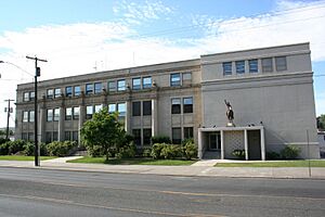
Nez Perce County Courthouse in Lewiston, Idaho
|
||
|
||

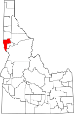
Location within the U.S. state of Idaho
|
||
 Idaho's location within the U.S. |
||
| Country | ||
| State | ||
| Founded | February 4, 1864 | |
| Named for | Nez Percé tribe | |
| Seat | Lewiston | |
| Largest city | Lewiston | |
| Area | ||
| • Total | 856 sq mi (2,220 km2) | |
| • Land | 848 sq mi (2,200 km2) | |
| • Water | 8.2 sq mi (21 km2) 0.85% | |
| Population
(2020)
|
||
| • Total | 42,090 | |
| • Density | 49.17/sq mi (18.985/km2) | |
| Time zone | UTC−8 (Pacific) | |
| • Summer (DST) | UTC−7 (PDT) | |
| Congressional district | 1st | |
Nez Perce County (pronounced NEZZ purse) is a county located in the U.S. state of Idaho. It is named after the Nez Perce tribe, a Native American group. In 2020, about 42,090 people lived in the county. The main city and county seat is Lewiston. Nez Perce County is part of the Lewiston, Idaho–WA Metropolitan Statistical Area.
Contents
History of Nez Perce County
Nez Perce County was first set up in 1861. At that time, this area was part of the Washington Territory. It was officially reorganized in 1864 by the Idaho Territorial Legislature.
Over time, parts of Nez Perce County were used to create new counties. For example, Latah County was formed in 1888. This happened because many people moved to the Palouse region in the 1880s.
Later, in 1904, a southern part of Shoshone County joined Nez Perce County. This area was far from its own county seat. Then, in 1911, this part became Clearwater County. Lewis County was also created from Nez Perce County in 1911.
Geography and Natural Features
Nez Perce County covers a total area of 856 square miles. About 848 square miles is land, and 8.2 square miles (or 1.0%) is water.
Rivers and Waterways
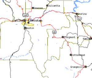
Two important rivers flow through Nez Perce County: the Clearwater River and the Snake River. These two rivers meet in the city of Lewiston. From there, they flow west.
The Clearwater River comes from the east, and the Snake River comes from the south. The Snake River also forms part of Idaho's border with Washington state. The lowest point in all of Idaho is found on the Snake River in Lewiston. This is where the river leaves Idaho and flows into Washington.
The Palouse Region
The northern part of Nez Perce County is part of the Palouse. This is a large, rolling agricultural area. It is known for its beautiful hills and farms. The Palouse is located in the middle of the Columbia basin.
Neighboring Counties
Nez Perce County shares borders with several other counties:
- Latah County – to the north
- Clearwater County – to the northeast
- Lewis County – to the east
- Idaho County – to the southeast (this border is also where the time zone changes)
- Wallowa County, Oregon – to the southwest
- Asotin County, Washington – to the west
- Whitman County, Washington – to the northwest
Major Roads and Highways
Several important roads run through Nez Perce County, connecting its communities and linking it to other areas:
Protected Natural Areas
Parts of these national protected areas are located within Nez Perce County:
- Clearwater National Forest
- Nez Perce National Historical Park
- Wallowa–Whitman National Forest
Population and People
| Historical population | |||
|---|---|---|---|
| Census | Pop. | %± | |
| 1870 | 1,607 | — | |
| 1880 | 3,965 | 146.7% | |
| 1890 | 2,847 | −28.2% | |
| 1900 | 13,748 | 382.9% | |
| 1910 | 24,860 | 80.8% | |
| 1920 | 15,253 | −38.6% | |
| 1930 | 17,591 | 15.3% | |
| 1940 | 18,873 | 7.3% | |
| 1950 | 22,568 | 19.6% | |
| 1960 | 27,066 | 19.9% | |
| 1970 | 30,276 | 11.9% | |
| 1980 | 33,220 | 9.7% | |
| 1990 | 33,754 | 1.6% | |
| 2000 | 37,410 | 10.8% | |
| 2010 | 39,265 | 5.0% | |
| 2020 | 42,090 | 7.2% | |
| 2023 (est.) | 42,987 | 9.5% | |
| U.S. Decennial Census 1790–1960, 1900–1990, 1990–2000, 2010–2020 2020 |
|||
As of the 2010 United States Census, about 39,265 people lived in Nez Perce County. Most people (90.1%) were white. About 5.6% were American Indian, and other groups made up smaller percentages. About 2.8% of the population was of Hispanic or Latino origin.
Many families live in the county. In 2010, about 28.1% of households had children under 18 living with them. The average age of people in the county was about 40.8 years old.
Communities in Nez Perce County
Nez Perce County has several cities and smaller communities.
Cities
Census-designated place
- Sweetwater (A census-designated place is a community that looks like a town but isn't officially incorporated as a city.)
Unincorporated communities
These are smaller communities that are not officially part of a city or town:
See also
 In Spanish: Condado de Nez Perce para niños
 | Selma Burke |
 | Pauline Powell Burns |
 | Frederick J. Brown |
 | Robert Blackburn |


