Shoshone County, Idaho facts for kids
Quick facts for kids
Shoshone County
|
||
|---|---|---|

|
||
|
||

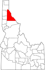
Location within the U.S. state of Idaho
|
||
 Idaho's location within the U.S. |
||
| Country | ||
| State | ||
| Founded | February 4, 1864 | |
| Named for | Shoshone tribe | |
| Seat | Wallace | |
| Largest city | Kellogg | |
| Area | ||
| • Total | 2,635 sq mi (6,820 km2) | |
| • Land | 2,630 sq mi (6,800 km2) | |
| • Water | 5.5 sq mi (14 km2) 0.2% | |
| Population
(2020)
|
||
| • Total | 13,169 | |
| • Density | 4.9977/sq mi (1.9296/km2) | |
| Time zone | UTC−8 (Pacific) | |
| • Summer (DST) | UTC−7 (PDT) | |
| Congressional district | 1st | |
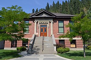
Shoshone County (pronounced shə-SHOHN) is a county in the U.S. state of Idaho. In 2020, about 13,169 people lived there. The main town, called the county seat, is Wallace. The biggest city in the county is Kellogg. Shoshone County was created in 1864. It was named after the Native American Shoshone tribe.
Many people call Shoshone County the Silver Valley. This is because of its long history of mining. The Silver Valley is well-known for the large amounts of silver, lead, and zinc found there.
Contents
A Look at Shoshone County's Past
Shoshone County was first formed on January 9, 1861. This happened when it was part of the Territory of Washington. Lawmakers created the county because they expected a gold rush. Gold had been found near Pierce in October 1860.
At first, the county's boundaries were a bit confusing. The new gold town of Pierce was accidentally outside the county. But a new settlement called Franklin was inside. Still, Pierce became the first county seat.
Pierce grew very quickly. In July 1861, Shoshone County had the most voters in the Washington Territory. Soon, other towns like Lewiston and Florence appeared.
On December 20, 1861, two new counties were created. Nez Perce and Idaho counties took most of Shoshone County's land. The next day, Shoshone's borders moved north. This new area included parts of what is now Clearwater County.
After these changes, only Pierce and Orofino were left in Shoshone County. Many gold seekers left Pierce for other areas. By 1863, only 574 people lived in Shoshone County.
Idaho Territory was created in 1863. On February 4, 1864, the county's boundaries were expanded. This new area included the Silver Valley. At that time, the Silver Valley had no people living there. All 276 residents of the county were still in Pierce and Orofino. By 1870, many people of Chinese descent lived in the county.
Until 1904, Shoshone County included what is now Clearwater County. That southern part later became its own county in 1911. As the Silver Valley grew in the 1880s, the county seat moved. It moved to Murray in 1884. Later, in 1898, it moved to Wallace. This helped serve the growing population better.
Miners in Shoshone County faced tough times. In 1892, they protested against lower wages. There were serious conflicts, and the U.S. Army had to step in. More conflicts happened in 1899. Miners had disagreements with the Bunker Hill & Sullivan mill. Again, the U.S. Army was called to help. Governor Frank Steunenberg was killed in 1905. This happened almost five years after he left office. The trials that followed made national news.
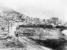
A large part of the county was burned in the Great Fire of 1910. This included parts of Wallace.
Geography and Nature

The U.S. Census Bureau says Shoshone County covers about 2,635 square miles. Most of this area, about 2,630 square miles, is land. The rest, about 5.5 square miles, is water.
Neighboring Counties
Shoshone County shares borders with several other counties:
- Bonner County (north)
- Sanders County, Montana (northeast)
- Mineral County, Montana (southeast)
- Clearwater County (south)
- Latah County (southwest)
- Benewah County (west)
- Kootenai County (northwest)
Main Roads
Important roads that go through Shoshone County include:
 I-90
I-90 I-90 Business Spur
 SH 3
SH 3- SH 4
Public Lands and Forests
Parts of these national forests are in Shoshone County:
- Clearwater National Forest
- Coeur d'Alene National Forest
- St. Joe National Forest
People of Shoshone County
| Historical population | |||
|---|---|---|---|
| Census | Pop. | %± | |
| 1870 | 722 | — | |
| 1880 | 469 | −35.0% | |
| 1890 | 5,382 | 1,047.5% | |
| 1900 | 11,950 | 122.0% | |
| 1910 | 13,963 | 16.8% | |
| 1920 | 14,250 | 2.1% | |
| 1930 | 19,060 | 33.8% | |
| 1940 | 21,230 | 11.4% | |
| 1950 | 22,806 | 7.4% | |
| 1960 | 20,876 | −8.5% | |
| 1970 | 19,718 | −5.5% | |
| 1980 | 19,226 | −2.5% | |
| 1990 | 13,931 | −27.5% | |
| 2000 | 13,771 | −1.1% | |
| 2010 | 12,765 | −7.3% | |
| 2020 | 13,169 | 3.2% | |
| 2023 (est.) | 14,026 | 9.9% | |
| U.S. Decennial Census 1790–1960 1900–1990 1990–2000 2010–2020 2020 The county seat is Wallace, |
|||
In 2010, there were 12,765 people living in Shoshone County. There were 5,605 households, and 3,511 families. Most people (95.4%) were white. About 1.4% were American Indian. People of Hispanic or Latino origin made up 3.0% of the population.
Many people in the county have German (32.2%), Irish (17.6%), or English (13.5%) backgrounds. The average age of people in the county was 46.2 years old.
The average income for a household was about $36,654 per year. For families, it was about $44,685. About 17.9% of the population lived below the poverty line. This included 22.5% of those under 18 years old.
Towns and Places
Cities in Shoshone County
Other Communities
- Silverton (a census-designated place)
Small Towns and Areas (Unincorporated)
Former Towns (Ghost Town)
Skiing Fun
Shoshone County is home to two ski areas:
Schools in the County
Here are some of the school districts in Shoshone County:
- Avery School District 394
- Kellogg Joint School District 391
- Mullan School District 392
- St. Maries Joint School District 41
- Wallace School District 393
The county is also near North Idaho College.
Images for kids
See also
 In Spanish: Condado de Shoshone para niños
 | Kyle Baker |
 | Joseph Yoakum |
 | Laura Wheeler Waring |
 | Henry Ossawa Tanner |


