Mullan, Idaho facts for kids
Quick facts for kids
Mullan, Idaho
|
|
|---|---|

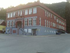
The historic Morning Club building (1921) in 2009
|
|

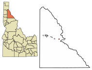
Location of Mullan in Shoshone County, Idaho.
|
|
| Country | United States |
| State | Idaho |
| County | Shoshone |
| Area | |
| • Total | 0.83 sq mi (2.14 km2) |
| • Land | 0.83 sq mi (2.14 km2) |
| • Water | 0.00 sq mi (0.00 km2) |
| Elevation | 3,307 ft (1,008 m) |
| Population
(2010)
|
|
| • Total | 692 |
| • Density | 836.76/sq mi (322.92/km2) |
| Time zone | UTC-8 (Pacific (PST)) |
| • Summer (DST) | UTC-7 (PDT) |
| ZIP code |
83846
|
| Area code(s) | 208, 986 |
| FIPS code | 16-55630 |
| GNIS feature ID | 2411194 |
Mullan is a small city in the northwest United States. It's found in the Silver Valley, a mining area in northern Idaho. In 2020, about 646 people lived there. This number was 692 in 2010 and 840 in 2000.
Mullan is in Shoshone County, at the eastern end of the Silver Valley. It sits in a protected canyon of the Coeur d'Alene Mountains, about 3,278 feet (999 meters) above sea level. Just east of the city, you'll find the entrance to the Lucky Friday mine. This active mine digs for silver, lead, and zinc. It goes down more than 6,000 feet (1.8 kilometers) below the ground!
Interstate 90 runs along the south side of Mullan. The border with Montana is about 6 miles (10 km) east at Lookout Pass. This pass is about 4,700 feet (1,433 meters) above sea level.
Contents
History of Mullan: A Mining Town's Story
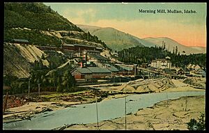
Mullan started as a town in 1884. This happened after gold was found at the Gold Hunter Mine. This mine later became known for producing lead and silver. In the same year, George Good found a lot of lead and silver at the Morning Mine. Mullan grew up between these two important mines.
The town site was officially recorded in August 1888. By then, Mullan had twenty log homes and fifteen frame houses. It also had a sawmill and about 150 people living there. The Northern Pacific Railway arrived in 1889, making it easier to get to Mullan. The city officially became a city in 1904.
During a difficult time for miners in 1899, about two hundred miners from Mullan joined a group called the "Dynamite Express." After these events, many of Mullan's leaders were arrested. This included the sheriff, and they were sent to a place called the "bull pens" in Wallace.
The city was named after John Mullan (1830–1909). He was a West Point graduate and an engineer in the U.S. Army. John Mullan was in charge of finding a good route for a wagon road. This road, known as the Mullan Road, connected Fort Benton in Montana to Fort Walla Walla in Washington. He started gathering information for the road in 1854.
Construction of the Mullan Road began in 1859. It was delayed for a while by the Coeur d'Alene War of 1858. From where Mullan is today, the road went southeast up Willow Creek. It crossed into Montana at what is now St. Regis Pass. This pass was once called "Sohon Pass," named after artist Gustavus Sohon. He helped find this mountain gap, which is about a mile west of Lookout Pass.
The Mullan Road project was finished in 1860. However, floods soon damaged large parts of the road. It had to be re-routed in 1861, but floods damaged it again. Unfortunately, no plans were made to keep the road in good repair.
Mullan's population has become smaller over the years. It was largest in 1940, with 2,291 people.
Mullan Today: Community and Education
Mullan is much smaller now than it was when the Morning and Lucky Friday mines were at their busiest. The Mullan School District serves the community. It includes the John Mullan Elementary School for students in kindergarten through 6th grade. There is also the Mullan Junior/Senior High School for grades 7-12. This school opened in 1927.
Mullan has its own fire department to keep everyone safe. The city also has an Olympic-size swimming pool (50 meters or 55 yards long) for everyone to enjoy. You can reach Mullan easily from Interstate 90 by taking exits 67, 68, or 69.
Geography of Mullan
Mullan covers a total area of about 0.84 sq mi (2.14 sq km). All of this area is land.
Climate in Mullan: Seasons and Snowfall
Mullan has a humid continental climate. This means it experiences all four seasons. Summers are usually warm, with cool nights. Winters are cold and snowy. On average, Mullan gets about 112 inches (284 cm) of snow each year.
| Climate data for Mullan, Idaho, 1991–2020 normals, extremes 1958–present | |||||||||||||
|---|---|---|---|---|---|---|---|---|---|---|---|---|---|
| Month | Jan | Feb | Mar | Apr | May | Jun | Jul | Aug | Sep | Oct | Nov | Dec | Year |
| Record high °F (°C) | 58 (14) |
66 (19) |
76 (24) |
87 (31) |
93 (34) |
103 (39) |
101 (38) |
105 (41) |
95 (35) |
87 (31) |
69 (21) |
57 (14) |
105 (41) |
| Mean daily maximum °F (°C) | 35.1 (1.7) |
38.5 (3.6) |
46.2 (7.9) |
54.7 (12.6) |
65.3 (18.5) |
71.0 (21.7) |
80.8 (27.1) |
81.2 (27.3) |
70.7 (21.5) |
55.2 (12.9) |
40.9 (4.9) |
32.2 (0.1) |
56.0 (13.3) |
| Daily mean °F (°C) | 28.8 (−1.8) |
30.5 (−0.8) |
36.5 (2.5) |
43.5 (6.4) |
52.7 (11.5) |
58.1 (14.5) |
65.0 (18.3) |
64.7 (18.2) |
56.2 (13.4) |
44.4 (6.9) |
34.1 (1.2) |
27.2 (−2.7) |
45.1 (7.3) |
| Mean daily minimum °F (°C) | 22.5 (−5.3) |
22.4 (−5.3) |
26.7 (−2.9) |
32.4 (0.2) |
40.2 (4.6) |
45.2 (7.3) |
49.2 (9.6) |
48.2 (9.0) |
41.8 (5.4) |
33.6 (0.9) |
27.3 (−2.6) |
22.1 (−5.5) |
34.3 (1.3) |
| Record low °F (°C) | −23 (−31) |
−18 (−28) |
−9 (−23) |
12 (−11) |
21 (−6) |
26 (−3) |
27 (−3) |
29 (−2) |
20 (−7) |
−2 (−19) |
−16 (−27) |
−27 (−33) |
−27 (−33) |
| Average precipitation inches (mm) | 4.14 (105) |
3.54 (90) |
4.47 (114) |
2.98 (76) |
2.53 (64) |
2.97 (75) |
0.95 (24) |
0.98 (25) |
1.57 (40) |
3.93 (100) |
4.70 (119) |
3.80 (97) |
36.56 (929) |
| Average snowfall inches (cm) | 24.8 (63) |
23.3 (59) |
9.8 (25) |
4.3 (11) |
0.3 (0.76) |
0.0 (0.0) |
0.0 (0.0) |
0.0 (0.0) |
trace | 2.4 (6.1) |
18.1 (46) |
31.1 (79) |
114.1 (289.86) |
| Average precipitation days (≥ 0.01 in) | 16.3 | 14.6 | 16.4 | 14.3 | 14.4 | 12.0 | 7.6 | 6.8 | 8.1 | 11.9 | 19.7 | 17.1 | 159.2 |
| Average snowy days (≥ 0.1 in) | 11.7 | 9.2 | 7.7 | 3.9 | 0.6 | 0.0 | 0.0 | 0.0 | 0.1 | 1.6 | 10.1 | 13.5 | 58.4 |
| Source 1: NOAA (precip days, snow/snow days 1981–2010) | |||||||||||||
| Source 2: National Weather Service | |||||||||||||
People of Mullan: Demographics and Community Life
| Historical population | |||
|---|---|---|---|
| Census | Pop. | %± | |
| 1910 | 1,667 | — | |
| 1920 | 1,320 | −20.8% | |
| 1930 | 1,891 | 43.3% | |
| 1940 | 2,291 | 21.2% | |
| 1950 | 2,036 | −11.1% | |
| 1960 | 1,477 | −27.5% | |
| 1970 | 1,279 | −13.4% | |
| 1980 | 1,269 | −0.8% | |
| 1990 | 821 | −35.3% | |
| 2000 | 840 | 2.3% | |
| 2010 | 692 | −17.6% | |
| 2020 | 646 | −6.6% | |
| 2019 (est.) | 692 | 0.0% | |
| U.S. Decennial Census | |||
In 2010, the city of Mullan had 692 people living there. These people made up 326 households, with 193 of them being families. The population density was about 824 people per square mile (318 people per square kilometer).
Most of the people in Mullan (95.8%) were White. About 1.0% were Native American. A small number of people were Asian or Pacific Islander. Some people identified as being from two or more races. About 2.2% of the population was Hispanic or Latino.
Out of the 326 households, 20.2% had children under 18 living with them. Almost half (46.3%) were married couples living together. About 8.0% of households had a female head with no husband present. And 4.9% had a male head with no wife present. Many households (40.8%) were not families.
About 36.5% of all households were made up of people living alone. Of these, 18.1% were people aged 65 or older living by themselves. The average household had 2.12 people, and the average family had 2.72 people.
The average age of people in Mullan was 48.3 years. About 17.9% of residents were under 18 years old. About 6.8% were between 18 and 24. The largest group, 33.8%, was between 45 and 64 years old. About 20.5% of the population was 65 years or older. In terms of gender, 51.9% of the population was male and 48.1% was female.
See also
 In Spanish: Mullan (Idaho) para niños
 | DeHart Hubbard |
 | Wilma Rudolph |
 | Jesse Owens |
 | Jackie Joyner-Kersee |
 | Major Taylor |


