
Wallace, Idaho facts for kids
Quick facts for kids
Wallace, Idaho
|
|
|---|---|
|
City
|
|

Buildings in Wallace's historic district
|
|
| Nickname(s):
Silver Capital of the World
|
|

Location of Wallace in Shoshone County, Idaho.
|
|

Wallace, Idaho
Location in the United States
|
|
| Country | United States |
| State | Idaho |
| County | Shoshone |
| Founded | 1884 |
| Area | |
| • Total | 0.91 sq mi (2.35 km2) |
| • Land | 0.91 sq mi (2.35 km2) |
| • Water | 0.00 sq mi (0.00 km2) |
| Elevation | 2,730 ft (830 m) |
| Population
(2010)
|
|
| • Total | 784 |
| • Estimate
(2019)
|
782 |
| • Density | 861.23/sq mi (332.38/km2) |
| Time zone | UTC−8 (Pacific (PST)) |
| • Summer (DST) | UTC−7 (PDT) |
| ZIP codes |
83873-83874
|
| Area code(s) | 208, 986 |
| FIPS code | 16-84790 |
| GNIS feature ID | 392796 |

Wallace, Idaho is a small city in Shoshone County, Idaho. It's located in the Silver Valley mining area. This region is famous for its silver mines.
Wallace was founded in 1884. It sits next to the South Fork of the Coeur d'Alene River. Interstate 90 also runs through the city. Wallace is about 2,730 feet (832 meters) above sea level. In 2010, about 784 people lived there.
Wallace is the main town in the Coeur d'Alene silver-mining district. This area has produced more silver than any other mining district in the United States. The Burke-Canyon Road leads to old mining towns. Many of these towns are now deserted. The ghost town of Burke, Idaho is about 7 miles (11 km) away. East of Wallace, you can find the Route of the Hiawatha. This is a popular trail for biking and walking. The Lookout Pass ski area is also nearby. Both are popular with locals and visitors.
Contents
History of Wallace

The city of Wallace was named after Colonel W.R. Wallace, who owned land here. In 1890, Shoshone County was the most populated county in Idaho. Wallace was its biggest city and the third largest in the state. About 2,000 people lived there then.
The area had some tough times between miners and mine owners. In 1892, hard rock miners went on strike because their wages were cut. There were some violent events, and the U.S. Army had to step in to end the strike. More problems happened in 1899. Miners blew up the Bunker Hill & Sullivan mill. They were upset because the company fired workers for joining a union. Again, the Army had to get involved.
A huge fire, called the Great Fire of 1910, destroyed one-third of Wallace. This fire burned about 3 million acres (12,000 km²) across Washington, Idaho, and Montana.
In 1979, many blocks in downtown Wallace were added to the National Register of Historic Places. This means the area is a historic district. This listing helps protect the old buildings.
Wallace's Geography and Climate
Wallace is located at 47.472923 degrees North and -115.924935 degrees West. The city covers about 0.84 square miles (2.18 square kilometers) of land.
Wallace has a climate with warm summers and cold, snowy winters. It can get a lot of rain, especially when mild air comes from the Pacific Ocean. Winters are usually not too harsh for a northern inland place. However, temperatures can get very cold when air comes from Canada. The record low temperature was -31°F (-35°C) in December 1968. Summers can be quite warm. The hottest month on record was July 2007.
People of Wallace
| Historical population | |||
|---|---|---|---|
| Census | Pop. | %± | |
| 1890 | 878 | — | |
| 1900 | 2,265 | 158.0% | |
| 1910 | 3,000 | 32.5% | |
| 1920 | 2,816 | −6.1% | |
| 1930 | 3,634 | 29.0% | |
| 1940 | 3,839 | 5.6% | |
| 1950 | 3,140 | −18.2% | |
| 1960 | 2,412 | −23.2% | |
| 1970 | 2,206 | −8.5% | |
| 1980 | 1,736 | −21.3% | |
| 1990 | 1,010 | −41.8% | |
| 2000 | 960 | −5.0% | |
| 2010 | 784 | −18.3% | |
| 2019 (est.) | 782 | −0.3% | |
| U.S. Decennial Census | |||
Wallace's Population in 2010
In 2010, the census showed 784 people living in Wallace. There were 364 households and 190 families. The city had about 933 people per square mile (360 people per square kilometer).
About 16% of the people were under 18 years old. About 19.5% were 65 years or older. The average age in the city was 47.5 years. There were slightly more males (52.9%) than females (47.1%).
Getting Around Wallace

You can reach Wallace using Interstate 90 and State Highway 4. The closest airport is Shoshone County Airport. It is about 15 miles (24 km) west of Wallace.
In the past, two railroads served Wallace. They carried passengers and freight. The old Northern Pacific Railway station is still standing. It was moved to avoid being torn down when the freeway was built. Today, it is a local railroad museum. Many old railroad lines have been turned into trails. The Trail of the Coeur d'Alenes runs through Wallace.
Another trail, the "Route of the Hiawatha Trail," is also nearby. It's a popular trail for biking. Wallace is often seen as the main starting point for people using this trail.
Interstate 90 and Wallace
Interstate 90 goes through Wallace on a raised highway. This part of the highway was finished in 1991. Before that, I-90 traffic used the main streets of downtown Wallace. Wallace used to have the very last traffic light on a coast-to-coast Interstate highway. This fact is even shown on signs in downtown Wallace.
The original plan for I-90 would have torn down most of downtown Wallace. But in the 1970s, city leaders worked to get downtown Wallace listed on the National Register of Historic Places. Now, every building in downtown Wallace is on the National Register. This meant that federal law protected the historic buildings. So, the highway had to be redesigned. The raised highway you see today was the solution.
Wallace in Movies and Fun Facts
The 1997 movie Dante's Peak was filmed in Wallace. The city was used as the fictional town "Dante's Peak" in Washington state. A large hill near the town was changed digitally to look like a volcano. Many local people from Wallace were extras in the movie. They appeared in scenes like the award ceremony and the festival.
On September 25, 2004, the mayor of Wallace, Ron Garitone, declared Wallace to be the "Center of the Universe". A special manhole cover marks the exact spot. It says "Center of the Universe. Wallace, Idaho." This event even inspired a British writer, Danny Wallace, to visit. He wrote a book about his trip called Danny Wallace and the Centre of the Universe. This fun event is celebrated every year in September.
Famous People from Wallace
- Weldon Heyburn (1852–1912), a U.S. Senator
- Doris Houck (1921–1965), an actress
- Guy McPherson (b. 1960), a scientist and professor
- Michael Norell (born 1937), an actor and screenwriter
- Ed Pulaski (1868–1931), a forest ranger known for his bravery in the Great Fire of 1910
- Mike Riley (born 1953), a former college football coach
- Lana Turner (1921–1995), a famous film actress, was born in Wallace
Images for kids
-
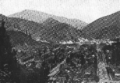
1904 image of Wallace, Idaho
-
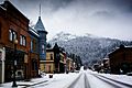
Downtown Wallace during winter


See also
 In Spanish: Wallace (Idaho) para niños
