Trail of the Coeur d'Alenes facts for kids
Quick facts for kids Trail of the Coeur d'Alenes |
|
|---|---|

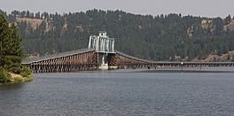
Crossing Lake Coeur d'Alene on the Chatcolet Bridge, a long wooden trestle bridge with a 1921-built, former-swing-span truss bridge section
|
|
| Length | 73 miles (117 km) |
| Location | Northern Idaho, U.S. |
| Established | March 2004 |
| Designation | Idaho state park |
| Trailheads | Mullan, Idaho; Plummer, Idaho 47°30′35″N 116°32′13″W / 47.50972°N 116.53694°W |
| Use | Biking, inline skating, hiking |
| Highest point | 3,280 ft (1,000 m) (Mullan) |
| Lowest point | 2,200 ft (670 m) (Harrison) |
| Difficulty | Easy |
| Season | Year-round |
| Sights | Silver Valley, Lake Coeur d'Alene, Heyburn State Park, Palouse |
| Surface | Asphalt |
| Maintained by | Idaho Department of Parks and Recreation |
| Website | Trail of the Coeur d'Alenes |
The Trail of the Coeur d'Alenes is a super cool path in northern Idaho, in the northwest part of the country. It's a special kind of trail called a rail trail, which means it was built on an old railroad line. This trail stretches from Mullan, a mountain town close to Montana, all the way west to Plummer, a town near the Washington border.
The trail mostly follows the Coeur d'Alene River. The old railroad tracks were removed in 1991. Then, in March 2004, this awesome trail officially opened for everyone to enjoy!
Contents
Exploring the Trail of the Coeur d'Alenes
This amazing trail is about 73 miles (117 km) long. It winds through different kinds of landscapes. You'll see mountains, beautiful lakes, and even open prairies.
What You'll See Along the Way
- Mountain Views: The trail starts in the historic Silver Valley, which is a mountainous area.
- Chain Lakes and Lake Coeur d'Alene: You'll ride or walk past many small lakes. Then, you'll travel along the shore of the big and beautiful Lake Coeur d'Alene.
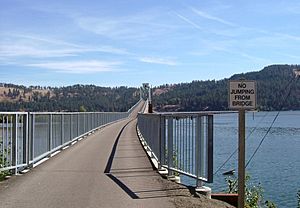
- Chatcolet Bridge: A cool part of the trail is crossing the Chatcolet Bridge. This bridge takes you over the lake and into Heyburn State Park.
- Palouse Prairie: The trail ends with a climb up to the northern Palouse prairie, which is a wide-open grassland.
If you keep going, you can even connect to another bike path in Washington that leads to the city of Spokane. The eastern part of the trail in Shoshone County runs near Interstate 90. In Kootenai County, the trail follows the river towards Harrison, closer to State Highway 3.
A Trail with a Past: Helping the Environment
The Trail of the Coeur d'Alenes is more than just a fun place to ride bikes or hike. It also helps solve environmental problems from the past. Long ago, people discovered valuable metals like silver, lead, and zinc in the valley around 1884. A railroad was built in 1888 to carry these metals from the mines.
How the Trail Helps
The ground where the railroad used to be had some harmful substances. These came from waste rock from the mines and spills from the trains. To fix this, several groups worked together:
- The Union Pacific Railroad
- The U.S. government
- The State of Idaho
- The Coeur d'Alene Tribe
They decided to build this trail! The thick asphalt surface and gravel barriers on the sides of the trail act like a special cap. This cap helps keep the harmful substances safely away from the environment around the trail.
Managed by the Tribe
A part of the trail, about 15 miles (24 km) long, is located within the Coeur d'Alene Reservation. This section is managed and cared for by the Coeur d'Alene Tribe.
Fun Things to Do on the Trail
The Trail of the Coeur d'Alenes has many great features for visitors. You'll find places to camp and rest areas along the way.
Wildlife and Nature
The trail goes through protected marsh lands. This means you might get to see amazing wildlife! Keep an eye out for:
- Birds: Eagles, ospreys, and many different kinds of ducks.
- Animals: Moose and elk.
- Plants: You might also spot some rare wildflowers and beautiful butterflies. These unique plants and insects have grown thanks to the rich soil, even with some soot from the old railroad days!
 | Roy Wilkins |
 | John Lewis |
 | Linda Carol Brown |


