
Burke, Idaho facts for kids
Quick facts for kids
Burke, Idaho
|
|
|---|---|

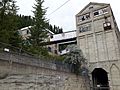
East hillside of Burke as seen in 2017
|
|

Burke, Idaho
Location in Idaho

Burke, Idaho
Location in the United States
|
|
| Country | United States |
| State | Idaho |
| County | Shoshone |
| Elevation | 3,700 ft (1,100 m) |
| Time zone | UTC-8 (Pacific (PST)) |
| • Summer (DST) | UTC-7 (PDT) |
| ZIP code |
83807
|
| Area code(s) | 208, 986 |
Burke is a ghost town in Shoshone County, Idaho, United States. It was founded in 1887. This town was once a busy place for mining silver, lead, and zinc. However, it became much quieter in the mid-1900s after many mines closed down.
In its early days, Burke was home to important mines like the Hercules, Hecla, and Star mines. The town's location was very special. It was built in a very narrow canyon, only about 300-foot (91 m)-wide. This meant buildings had to be built in unique ways. For example, a hotel was built right over the railway and a creek, with the train tracks actually running through part of the hotel lobby!
After some natural disasters and a slowdown in mining, the last mine in Burke closed in 1991. By 2002, about 300 people lived in or near Burke Canyon, but Burke itself had no residents.
Burke is located about 7 miles (11 km) northeast of Wallace. It sits at an elevation of 3,700 feet (1,130 m) above sea level. You can reach it from Wallace by taking Burke-Canyon Creek Road (State Highway 4). The town is also about 100 miles (160 km) south of British Columbia, Canada, and roughly 5 miles (8.0 km) west of Montana.
Contents
History of Burke
How Burke Began

| Historical population | |||
|---|---|---|---|
| Census | Pop. | %± | |
| 1890 | 482 | — | |
| 1900 | 1,081 | 124.3% | |
| 1910 | 1,400 | 29.5% | |
| 1920 | 1,135 | −18.9% | |
| 1930 | 1,027 | −9.5% | |
| 1940 | 963 | −6.2% | |
| 1950 | 800 | −16.9% | |
| 1960 | 300 | −62.5% | |
| 1970 | 150 | −50.0% | |
| 1980 | 80 | −46.7% | |
| 1990 | 15 | −81.2% | |
In 1884, miners found a lot of lead and silver in the Burke Canyon. The first mine, called the Tiger Mine, was found in May 1884. Later that year, the Tiger Mine was sold for $35,000.
By the end of 1885, over 3,000 tons of ore had been dug out from the Tiger Mine. Because so much ore was being found, a railroad was needed to move it. Construction began on a railway from the mine to Wallace. On July 6, 1887, the Canyon Creek Railroad was officially started. It was a narrow-gauge railway, 3 ft (0.91 m)-wide, running from Wallace to the Tiger Mine.
By September 1887, not much work had been done on the railway. A huge amount of mined ore, over 100,000 pounds (45,000 kg), was waiting to be moved. This led to the railway being sold to D.C. Corbin. Under Corbin's guidance, 3 miles (4.8 km) of tracks were laid by November 1887. This is when the town of Burke was officially created. The railway was finished in December 1887. The first shipment of ore to Wallace happened on December 12. By 1888, trains from the Northern Pacific Railroad and the Oregon Railroad and Navigation Company served the town.
Because Burke was in such a narrow canyon, it had to share space with the Northern Pacific rail line. This meant the railway ran right through the main street of town. Some stories say that businesses on the west side of the tracks had to pull in their awnings when trains passed. However, a resident named Bill Dunphy said this was an exaggeration. He recalled, "It was narrow. They always said that when a train came through Burke, you had to hoist the awnings to get the train through, which wasn't right. But, it's a good story."
On February 4, 1890, the first of many avalanches hit Burke. It caused a lot of damage to homes and businesses and sadly killed three people. In 1891, miners and mining companies started to have disagreements. In 1892, hard rock miners in Shoshone County went on strike because their wages were cut. Two large mines, the Gem mine and the Frisco mine, located 1 mile (1.6 km) south of Burke, continued to operate with new workers during the strike. On July 11, 1892, a conflict at the nearby Frisco Mill accidentally caused a box of dynamite to explode. This explosion destroyed the mill and killed six people. Idaho Governor Frank Steunenberg declared martial law. He sent the U.S. Army and National Guard into the canyon to help keep the peace.
Growth and Challenges
.jpg)
Burke continued to grow. The Tiger Hotel was built in 1896. It was a 150-room hotel that first served as a place for miners to stay. It was named after the Tiger Mine. A fire badly damaged the hotel shortly after it opened in 1896, and three people died. When the railroad was made wider in 1906, the hotel had to change. The hotel was built over the main street and Canyon Creek. It was changed so the railroad could run right through its lobby. A covered walkway was built above the railroad. This allowed hotel guests to move between the two parts of the hotel without worrying about the train or the weather.
Around 1896, Socialist leader Eugene V. Debs became well-known in the Pacific Northwest. He spoke to miners in Burke in early 1897. Two years later, in 1899, more problems arose. The Bunker Hill company fired seventeen men for joining the union. In response, miners caused an explosion at the Bunker Hill & Sullivan mill. More lives were lost, and the army had to step in again. While the Hecla mine continued to do well, the town faced more destruction in February 1910. Another avalanche hit Burke, killing twenty residents. Six months later, the Great Fire of 1910 caused even more damage to the Burke Canyon.
In 1913, major flooding affected the town. Mud and debris piled up against the Tiger Hotel as water rushed down the canyon. The town was hit by more damage on July 23, 1923, when another fire broke out. This fire caused a lot of damage to many buildings. The Tiger Hotel was especially damaged. It became less profitable in the 1940s and was torn down in 1954.
Burke's Decline
By the mid-1900s, mining in Burke had slowed down. Several mines had closed. The very last mine in Burke closed in 1991. According to official numbers, only fifteen people lived in Burke in 1990.
As of 2012, the Hecla Mining Company was looking into finding more resources in the Star mine. By December 31, 2012, Hecla had spent $7 million to fix up and explore the mine. Estimates suggested they could find over 25 million ounces (11.3 million kg) of silver there. There were also significant amounts of zinc and lead.

Climate in Burke
Burke has warm summers and cold, snowy winters. Its climate is known as a continental climate. Because it is deep within the narrow Burke Canyon, winters in Burke are especially harsh. The town only gets about 3 hours of full sunlight each day during winter.
| Climate data for 2 Miles ENE of Burke, Idaho (1907–1967) | |||||||||||||
|---|---|---|---|---|---|---|---|---|---|---|---|---|---|
| Month | Jan | Feb | Mar | Apr | May | Jun | Jul | Aug | Sep | Oct | Nov | Dec | Year |
| Record high °F (°C) | 48 (9) |
63 (17) |
65 (18) |
83 (28) |
86 (30) |
98 (37) |
95 (35) |
99 (37) |
92 (33) |
78 (26) |
62 (17) |
50 (10) |
99 (37) |
| Mean daily maximum °F (°C) | 28.7 (−1.8) |
34.3 (1.3) |
39.0 (3.9) |
47.7 (8.7) |
57.7 (14.3) |
65.6 (18.7) |
76.3 (24.6) |
74.1 (23.4) |
65.5 (18.6) |
52.0 (11.1) |
37.3 (2.9) |
30.9 (−0.6) |
50.8 (10.4) |
| Mean daily minimum °F (°C) | 15.9 (−8.9) |
19.5 (−6.9) |
21.6 (−5.8) |
27.5 (−2.5) |
32.9 (0.5) |
39.0 (3.9) |
44.2 (6.8) |
43.2 (6.2) |
38.6 (3.7) |
32.2 (0.1) |
24.7 (−4.1) |
19.1 (−7.2) |
29.9 (−1.2) |
| Record low °F (°C) | −24 (−31) |
−21 (−29) |
−15 (−26) |
8 (−13) |
13 (−11) |
26 (−3) |
20 (−7) |
23 (−5) |
21 (−6) |
4 (−16) |
−13 (−25) |
−26 (−32) |
−26 (−32) |
| Average precipitation inches (mm) | 6.69 (170) |
5.41 (137) |
4.92 (125) |
3.02 (77) |
2.95 (75) |
3.32 (84) |
1.23 (31) |
1.38 (35) |
2.54 (65) |
4.35 (110) |
6.02 (153) |
6.18 (157) |
48.01 (1,219) |
| Average snowfall inches (cm) | 59.9 (152) |
45.6 (116) |
42.4 (108) |
9.5 (24) |
3.7 (9.4) |
0.5 (1.3) |
0.0 (0.0) |
0.0 (0.0) |
0.2 (0.51) |
4.3 (11) |
27.7 (70) |
48.7 (124) |
242.5 (616.21) |
| Average precipitation days (≥ 0.01 in) | 20 | 16 | 16 | 12 | 13 | 12 | 6 | 7 | 8 | 12 | 17 | 18 | 157 |
| Source: Western Regional Climate Center | |||||||||||||
Famous People from Burke
- Wyatt Earp (1848–1929), a famous lawman, lived in a camp next to Burke called Eagle City around 1885.
- Lana Turner (1921–1995), a well-known actress, lived in Burke when she was a young child.
Gallery
-
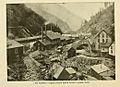
1904 image of Burke, Idaho, showing the Tiger-Poorman (left) and Hecla (right) mine shafts
-
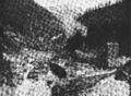
The Poorman, Burke, Idaho 1890
-
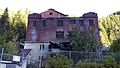
Hecla Mine Co. building
-
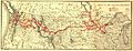
Map of Northern Pacific's route, around 1900
-
Skyway bridge connecting buildings
-
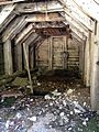
An abandoned mine shaft in Burke
-
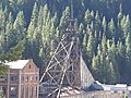
The Star mine shaft


.jpg)

.jpg)
