
Burke Canyon facts for kids
Quick facts for kids Burke Canyon |
|
|---|---|
.jpg)
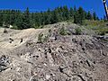
Cliffs above a mine in Burke Canyon.
|
|

Burke Canyon
Location in Idaho
|
|
| Floor elevation | 3,768 ft (1,148 m) |
| Length | 14 miles (23 km) Northeast–southwest |
| Width | 300 feet (91 m) |
| Geography | |
| Traversed by | Idaho State Highway 4 |
| Rivers | Burke-Canyon Creek |
Burke Canyon is a narrow valley in Shoshone County, Idaho, in the Silver Valley. A creek called Burke-Canyon Creek runs through it. This area was very important for mining in the late 1800s and 1900s.
Today, Burke Canyon has several ghost towns. These are towns where most people have left. You can still see parts of the old communities along Idaho State Highway 4. This road goes northeast through the canyon towards the Montana border.
The canyon is named after the town of Burke. People first came to the canyon in 1884. They found silver, lead, and zinc in the mines. Between 1886 and 1890, many mining towns grew in the canyon. These towns often had serious disagreements between miners and mine owners. This led to conflicts like the labor strike of 1892 and the confrontation of 1899.
Over time, the number of people in the canyon's towns went down. This happened after natural disasters and mines closing. The last active mine in the canyon shut down in 1991. This left most of the communities empty. The EPA has included Burke Canyon as a Superfund site. This is because the Burke-Canyon Creek has been polluted by metals and waste from mining.
Contents
History of Burke Canyon
Early Settlement and Mining Boom
Gold was first found in the mountains north of the Snake River in the 1860s. This brought many prospectors to the area. Soon after, silver, copper, and other valuable minerals were discovered. Idaho saw many "boom" times. Mining towns would appear very quickly, grow fast, and then disappear. This happened as miners moved on to the next big discovery.
In 1884, miners found a lot of silver, zinc, and lead at the Tiger Mine in Burke Canyon. This mine was later sold for $35,000. In 1887, a railway was built to carry ore from the Tiger Mine. A huge amount of ore had piled up from the canyon's mines. This led to the creation of the Canyon Creek Railroad. Its first shipment went to Wallace on December 12, 1887.
The railroad helped the town of Burke grow. The canyon is named after this town. Burke became the largest mining community in the canyon. In 1910, it had about 1,400 people. The town of Gem, south of Burke, was started in 1886. Both Gem and Burke attracted many miners, including a large number of people from Sweden. By 1903, Burke Canyon was the most developed mining area in the Coeur d'Alene Mountains. It had seven successful mines that paid dividends.
Challenges and Disasters

On July 10, 1892, miners went on strike. This led to an intense conflict between union miners and company guards. The first shots were fired at the Frisco mine on July 11. The gunfire caused dynamite in the Frisco Mill to explode. This destroyed the four-story mill and killed six people. The conflict then spread to the community of Gem. Union miners successfully shut down the Frisco and Gem mines. They then moved west to the Bunker Hill mining complex. They closed that facility too.
The Idaho National Guard and federal troops were sent to the area. This event was the first major conflict between mine workers and owners. Similar disagreements happened again at the Bunker Hill facility in 1899. Both times, the issues were about pay, work hours, and the miners' right to join a union. Mine owners also used informants. The actions by union miners were met with harsh responses in both 1892 and 1899.
Burke Canyon also faced several natural disasters. Two big avalanches hit the canyon. One on February 4, 1890, killed three people. Another in February 1910 buried and killed twenty-five people. After the 1910 avalanche, snow and rocks kept falling from the canyon walls. This caused more damage to Burke and Mace and led to more deaths. In August of that year, the Great Fire of 1910 also damaged the communities. Three years later, in May 1913, heavy rains caused major floods.
The Northern Pacific railroad thought about stopping service through the canyon. Their depot was damaged in a fire in July 1923. They also noted that more people were using cars. By 1939, the rail line to Burke was officially closed, and the tracks were removed.
Recent Times
By the late 1900s, mining in Burke Canyon had slowed down a lot. The Hecla Mine in Burke closed on June 30, 1983. This was because metal prices were low. The very last mine in Burke closed in 1991. After this, Burke and many nearby communities became ghost towns.
Around 2010, the Hecla Mining Company started looking into finding more resources in the Star mine. By December 2012, Hecla had spent $7 million to fix up and explore the mine. They believe they could find over 25 million ounces of silver there, along with a lot of zinc and lead.
Geography of Burke Canyon
Burke Canyon is a very narrow valley, like a deep gulch. It is about 300 feet (90 m) wide. There are steep cliffs and hills on both sides. The hillsides are so steep that the town of Burke only gets about 3 hours of full sunlight during winter.
Climate
Burke Canyon has a continental climate. This means it has warm summers and cold, snowy winters.
| Climate data for 2 Miles ENE of Burke, Idaho (1907–1967) | |||||||||||||
|---|---|---|---|---|---|---|---|---|---|---|---|---|---|
| Month | Jan | Feb | Mar | Apr | May | Jun | Jul | Aug | Sep | Oct | Nov | Dec | Year |
| Record high °F (°C) | 48 (9) |
63 (17) |
65 (18) |
83 (28) |
86 (30) |
98 (37) |
95 (35) |
99 (37) |
92 (33) |
78 (26) |
62 (17) |
50 (10) |
99 (37) |
| Mean daily maximum °F (°C) | 28.7 (−1.8) |
34.3 (1.3) |
39.0 (3.9) |
47.7 (8.7) |
57.7 (14.3) |
65.6 (18.7) |
76.3 (24.6) |
74.1 (23.4) |
65.5 (18.6) |
52.0 (11.1) |
37.3 (2.9) |
30.9 (−0.6) |
50.8 (10.4) |
| Mean daily minimum °F (°C) | 15.9 (−8.9) |
19.5 (−6.9) |
21.6 (−5.8) |
27.5 (−2.5) |
32.9 (0.5) |
39.0 (3.9) |
44.2 (6.8) |
43.2 (6.2) |
38.6 (3.7) |
32.2 (0.1) |
24.7 (−4.1) |
19.1 (−7.2) |
29.9 (−1.2) |
| Record low °F (°C) | −24 (−31) |
−21 (−29) |
−15 (−26) |
8 (−13) |
13 (−11) |
26 (−3) |
20 (−7) |
23 (−5) |
21 (−6) |
4 (−16) |
−13 (−25) |
−26 (−32) |
−26 (−32) |
| Average precipitation inches (mm) | 6.69 (170) |
5.41 (137) |
4.92 (125) |
3.02 (77) |
2.95 (75) |
3.32 (84) |
1.23 (31) |
1.38 (35) |
2.54 (65) |
4.35 (110) |
6.02 (153) |
6.18 (157) |
48.01 (1,219) |
| Average snowfall inches (cm) | 59.9 (152) |
45.6 (116) |
42.4 (108) |
9.5 (24) |
3.7 (9.4) |
0.5 (1.3) |
0.0 (0.0) |
0.0 (0.0) |
0.2 (0.51) |
4.3 (11) |
27.7 (70) |
48.7 (124) |
242.5 (616.21) |
| Average precipitation days (≥ 0.01 in) | 20 | 16 | 16 | 12 | 13 | 12 | 6 | 7 | 8 | 12 | 17 | 18 | 157 |
| Source: Western Regional Climate Center | |||||||||||||
Communities in Burke Canyon
In 2002, about 300 people lived in or near Burke Canyon. Many communities and former communities are located along Burke-Canyon Road. Several of them are now ghost towns. These communities include:
- Burke
- Mace
- Cornwall
- Black Bear
- Frisco
- Gem
- Webb
- Woodland Park

Environmental Concerns
Impact of Mining

Many years of mining caused different metals to get into Canyon Creek. This polluted much of Burke Canyon. Waste rock left over from mines released cadmium, lead, arsenic, and zinc into the creek. Scientists found that long parts of Canyon Creek had no fish. This was due to the high levels of metals in the water.
Canyon Creek is considered a Superfund site by the EPA. The metals from Canyon Creek also helped pollute the Coeur d'Alene River. This river is known as one of the most metal-polluted rivers in the world. In 2010, the United States Environmental Protection Agency (EPA) made plans to remove old rock piles and polluted soil in Burke Canyon.
The local water supply in Burke Canyon was also affected by metals. After the last mine closed in 1991, residents still got water from pipes that went into old mine shafts. Because of this, the metal content in Burke's water was 50 times higher than federal safety standards. In 2001, the EPA offered to buy homes from Burke Canyon residents because of the water pollution. However, the residents did not agree.
The next year, the EPA told the town of Burke to follow the Safe Drinking Water Act. But since there were only a few homes, it would have cost each household about $48,000 per year to fix the water system.
Waste Management
For many years, untreated wastewater from homes in Burke Canyon went directly into Canyon Creek. By the early 2000s, people in Burke were still dumping up to 6,000 US gallons (23,000 L) of untreated wastewater into the creek every day. In 2004, health and environmental groups tested homes in Burke. They found 30 occupied homes sending untreated waste into the creek. In 2007, money was set aside to help residents install new septic systems. This was to stop more pollution.
In 2016, the EPA announced a plan to build a waste storage site in lower Burke Canyon. This would help manage waste from Wallace. Some residents in the canyon were against this plan. They worried about more pollution from diesel trucks carrying waste through the canyon.
Gallery
-
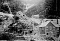
Frisco Mill after July 11, 1892 explosion
-
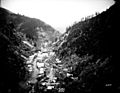
Overhead view of Burke in the Burke Canyon
-
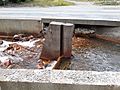
Flood gate along Burke-Canyon Creek
-
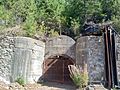
Entrance to Standard-Mammoth Mine in Mace
-
Covered mine shaft above Burke
-
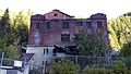
Hecla Mine Co. building in Burke


.jpg)

.jpg)

