
Lookout Pass Ski and Recreation Area facts for kids
Quick facts for kids Lookout Pass |
|
|---|---|

Lookout Pass
Location in Idaho

Lookout Pass
Location in the United States
|
|
| Location | Shoshone County, Idaho & Mineral County, Montana |
| Nearest city | Mullan: 5 mi (8 km) Coeur d'Alene: 56 mi (90 km) Spokane: 90 mi (145 km) Missoula: 100 mi (160 km) |
| Coordinates | 47°27′11″N 115°42′25″W / 47.453°N 115.707°W |
| Vertical | 1,150 ft (350 m) |
| Top elevation | 5,650 ft (1,720 m) |
| Base elevation | 4,500 ft (1,370 m) Timber Wolf chair 4,720 ft (1,440 m) Main base area |
| Skiable area | 540 acres (2.2 km2) |
| Runs | 34 |
| Longest run | 1.5 mi (2.4 km) |
| Lift system | 3 double chairs 1 triple lift (formerly rope tow) |
| Terrain parks | 2 |
| Snowfall | 400 in (1,020 cm) |
| Snowmaking | no |
| Night skiing | none |
| Website | Ski Lookout.com |
Lookout Pass Ski and Recreation Area is a fun ski area in the western United States. It sits right on the border of Idaho and Montana, near Interstate 90. The ski area is about five miles (8 km) east of Mullan.
Lookout Pass is on Runt Mountain and has a top elevation of 5,650 ft (1,720 m). The vertical drop, which is the difference between the top and bottom of the ski runs, is 1,150 ft (350 m). This ski area gets a lot of snow, with an average of over 350 inches (890 cm) each year!
Lookout Pass is open most days during the ski season. It has grown a lot since 2003, adding new areas for skiing and snowboarding. Today, it features two double chairlifts, one quad chairlift, and one triple chairlift.
Contents
History of Lookout Pass
Lookout Pass first opened in 1935. It started as a community ski hill, run by the Idaho Ski Club. Over the years, it slowly improved. The very first chairlift was put in during the summer of 1982.
In 1992, the ski hill was sold to a new company. Then, in 1999, it was sold again, and new plans for making the area bigger began.
Expanding the Ski Area
A big new part of the ski area opened on December 26, 2003. This new section was on the Montana side of the border. It added the Timber Wolf double chairlift and five new ski runs. This expansion also made the vertical drop bigger by lowering the base elevation.
In 2006, even more expansion happened on the Idaho "North Side." This added more intermediate and expert runs for skiers and snowboarders. In 2020, an older chairlift was replaced with a brand new, faster quad chairlift.
Terrain Parks for Fun
Lookout Pass has two special terrain parks where you can practice tricks. There's also a quarter pipe that is 1,111 feet (340 m) long. These parks are great for freestyle skiing and snowboarding!
Famous Skiers from Lookout Pass
Some talented skiers who trained at Lookout Pass went on to join the U.S. Ski Team.
- Beverly Anderson (born 1938) – She competed in the 1960 Winter Olympics.
- Jim Barrier (1940–2000) – He also competed in the 1960 Winter Olympics.
Route of the Hiawatha Trail
Lookout Pass is also a starting point for the famous Route of the Hiawatha Trail. This is a mountain bike trail that follows an old railroad path. It starts in Montana and goes downhill through long tunnels and over tall bridges called trestles. The trail is about fifteen miles (24 km) long.
The trail is named after the Olympian Hiawatha passenger trains that used to run on these tracks. Now, the trail is a fun place for biking. It includes a long tunnel at St. Paul Pass, which is 1.66 miles (2.7 km) long!
You can ride your bike on the trail, and there's even a bus service to take you back to the start. There is a small fee to ride the trail, and it's closed during the winter. You can find parking and camping spots near the start and end of the trail.
Other Nearby Trails
Another cool bike trail nearby is the Trail of the Coeur d'Alenes. This trail starts in Mullan and goes for over seventy miles (110 km) to the west. It follows another old railroad path and crosses Lake Coeur d'Alene.
Images for kids
-
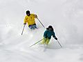
Downhill skiing at Lookout Pass
-
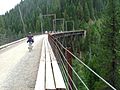
Route of the Hiawatha trestle
.jpg)
.jpg)
