Mineral County, Montana facts for kids
Quick facts for kids
Mineral County
|
|
|---|---|

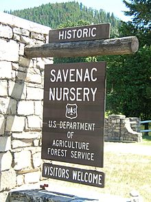
Welcome Sign at Historic Savenac Tree Nursery
|
|

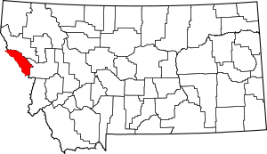
Location within the U.S. state of Montana
|
|
 Montana's location within the U.S. |
|
| Country | |
| State | |
| Founded | 1914 |
| Seat | Superior |
| Largest town | Superior |
| Area | |
| • Total | 1,223 sq mi (3,170 km2) |
| • Land | 1,219 sq mi (3,160 km2) |
| • Water | 3.8 sq mi (10 km2) 0.3% |
| Population
(2020)
|
|
| • Total | 4,535 |
| • Estimate
(2022)
|
5,058 |
| • Density | 3.7081/sq mi (1.4317/km2) |
| Time zone | UTC−7 (Mountain) |
| • Summer (DST) | UTC−6 (MDT) |
| Congressional district | 1st |
|
|
Mineral County is a cool place in the state of Montana, USA. It was created in 1914. In 2020, about 4,535 people lived there. The main town, where the county government is, is called Superior.
Contents
Geography of Mineral County
Mineral County covers a total area of about 1,223 square miles. Most of this area is land, with only a small part being water. It's a great place to explore nature!
Main Roads in Mineral County
These are the important highways that go through Mineral County:
 Interstate 90: This is a major highway that crosses the entire United States.
 U.S. Route 10 (Former): This used to be a main road, but now Interstate 90 has taken its place in many areas.
 Montana Highway 135: A state highway that helps people get around locally.
Neighboring Counties
Mineral County shares its borders with other counties:
- Sanders County to the north
- Missoula County to the east
- Clearwater County, Idaho to the southwest (this border is also where the time zone changes!)
- Shoshone County, Idaho to the northwest (another time zone border!)
National Forest Areas
Part of the Lolo National Forest is located in Mineral County. This is a large protected area with lots of trees and wildlife, managed by the U.S. Forest Service.
Population of Mineral County
| Historical population | |||
|---|---|---|---|
| Census | Pop. | %± | |
| 1920 | 2,327 | — | |
| 1930 | 1,626 | −30.1% | |
| 1940 | 2,135 | 31.3% | |
| 1950 | 2,081 | −2.5% | |
| 1960 | 3,037 | 45.9% | |
| 1970 | 2,958 | −2.6% | |
| 1980 | 3,675 | 24.2% | |
| 1990 | 3,315 | −9.8% | |
| 2000 | 3,884 | 17.2% | |
| 2010 | 4,223 | 8.7% | |
| 2020 | 4,535 | 7.4% | |
| 2022 (est.) | 5,058 | 19.8% | |
| U.S. Decennial Census 1790–1960, 1900–1990, 1990–2000, 2010–2020 |
|||
The population of Mineral County has changed over the years. In 1920, there were about 2,327 people. By 2020, the population had grown to 4,535 people. This shows how the number of residents has increased over time.
Towns and Communities
Mineral County has several towns and smaller communities where people live.
Main Towns
- Alberton
- Superior (This is the county seat, meaning it's where the county government offices are located.)
Smaller Communities
These places are called "census-designated places" because the government counts the people living there, even if they aren't officially towns:
Other Small Places
There are also many other small, unincorporated communities in Mineral County:
- Borax (part of Saltese)
- Bryson
- Cabin City
- Drexel
- East Portal
- Henderson
- Keystone
- Lozeau
- Quartz
- Sohon
- Spring Gulch
- Tammany
- Tarkio
- Westfall
Historic Communities
- Taft: This was once a community, but it is no longer active.
See also
 In Spanish: Condado de Mineral (Montana) para niños
 | Madam C. J. Walker |
 | Janet Emerson Bashen |
 | Annie Turnbo Malone |
 | Maggie L. Walker |

