Saltese, Montana facts for kids
Quick facts for kids
Saltese, Montana
Packers Meadow
Silver City |
|
|---|---|

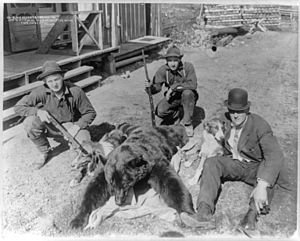
Black bear weighing 252 lbs. shot by Jim O'Brine at Saltese, Montana, May 12, 1910
|
|
| Country | United States |
| State | Montana |
| County | Mineral |
| Named for | Chief Saltese |
| Area | |
| • Total | 0.33 sq mi (0.85 km2) |
| • Land | 0.33 sq mi (0.85 km2) |
| • Water | 0.00 sq mi (0.00 km2) |
| Elevation | 3,389 ft (1,033 m) |
| Population
(2020)
|
|
| • Total | 10 |
| • Density | 30.40/sq mi (11.75/km2) |
| Time zone | UTC-7 (MST) |
| • Summer (DST) | UTC-6 (MDT) |
| ZIP Code |
59867
|
| Area Code | 406 |
| FIPS code | 30-65875 |
| GNIS feature ID | 2806650 |
Saltese is a small community in Mineral County, Montana, United States. It is also known as Packers Meadow or Silver City. This area is located in the valley of the St. Regis River. You can find it right off Interstate 90 at exit 10. In 2020, only 10 people lived here.
A Look Back in Time
Saltese was once a busy town where people mined for gold and silver. It got its name from a Nez Perce leader named Chief Saltese. The town was first called Silver City. However, its name was changed to Saltese in 1891. A post office opened in the community in 1892.
In December 1912, David D. Bogart was exploring for gold in Saltese. He was a former mayor of Missoula, Montana. Sadly, he died in an avalanche there. In 1996, a well-known local spot, the Old Montana Bar and Grille, was destroyed by a fire.
Where is Saltese Located?
Saltese is in the northwestern part of Mineral County. It sits at an elevation of about 3,370 feet (1,027 meters). The community is in the narrow valley of the St. Regis River. Packer Creek joins the river from the north, and Silver Creek joins from the south. The St. Regis River flows southeast into the Clark Fork River.
Interstate 90 runs through Saltese. If you head southeast on the interstate, you will reach Superior. Superior is about 36 miles (58 km) away and is the county seat of Mineral County. If you go northwest, you will cross Lookout Pass. This path leads to Mullan, Idaho, which is about 16 miles (26 km) away.
The Saltese area, as defined by the U.S. Census Bureau, covers about 0.33 square miles (0.85 square kilometers). All of this area is land.
How Many People Live Here?
| Historical population | |||
|---|---|---|---|
| Census | Pop. | %± | |
| 2020 | 10 | — | |
| U.S. Decennial Census | |||
According to the 2020 census, 10 people live in Saltese.
 | Claudette Colvin |
 | Myrlie Evers-Williams |
 | Alberta Odell Jones |

