St. Regis River (Montana) facts for kids
Quick facts for kids Saint Regis River |
|
|---|---|

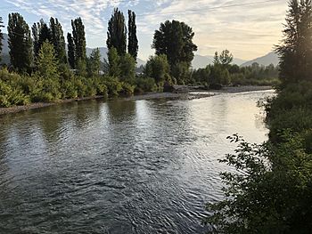
The St. Regis River near its mouth
|
|
| Country | Mineral County, Montana |
| Physical characteristics | |
| Main source | 47°25′33″N 115°45′02″W / 47.42583°N 115.75056°W |
| River mouth | 2,631 ft (802 m) 47°17′48″N 115°05′25″W / 47.29667°N 115.09028°W |
| Length | 32.5 mi (52.3 km) |
| Basin features | |
| River system | Columbia River |
| Basin size | 330 sq mi (850 km2) |
The St. Regis River is a river in Montana, United States. It's about 32.5 miles (52.3 kilometers) long. This river is a smaller stream that flows into the Clark Fork. The Clark Fork is a much bigger river that eventually joins the massive Columbia River.
Where the River Starts and Ends
The St. Regis River begins its journey at a place called Lookout Pass. This spot is right on the border between Idaho and Montana. From there, the river flows towards the east. It travels through the land until it reaches the town of St. Regis. This is where it meets and joins the Clark Fork River.
How Much Area It Covers
The area of land that drains water into the St. Regis River is quite large. It covers about 330 square miles (850 square kilometers). This entire area is called its "drainage basin." All the rain and snow that falls in this basin eventually flows into the St. Regis River.
River Flow Records
Rivers can have different amounts of water flowing through them. This depends on things like rain and melting snow. The highest amount of water ever recorded flowing in the St. Regis River was on May 19, 1954. On that day, about 11,000 cubic feet of water flowed past a certain point every second! That's a lot of water moving very fast.
 | Jessica Watkins |
 | Robert Henry Lawrence Jr. |
 | Mae Jemison |
 | Sian Proctor |
 | Guion Bluford |

