
Lolo National Forest facts for kids
Quick facts for kids Lolo National Forest |
|
|---|---|

Rainy Lake in Lolo National Forest
|
|

Lolo National Forest
Location in the United States
|
|
| Location | Montana, United States |
| Nearest city | Missoula, Montana |
| Area | 2,197,966 acres (8,894.85 km2) |
| Established | September 20, 1906 |
| Governing body | U.S. Forest Service |
| Website | Lolo National Forest |
The Lolo National Forest is a huge national forest located in western Montana, United States. Its western edge even touches the state of Idaho. This amazing forest covers about 2 million acres (that's over 8,000 square kilometers!). It's a special place with lots of different plants and animals.
Lolo National Forest is home to four special "wilderness areas." These are places where nature is protected and left wild. Two of these, the Welcome Creek and Rattlesnake Wildernesses, are completely inside Lolo National Forest. Parts of the Scapegoat and Selway-Bitterroot Wilderness are also found here. The forest was first created in 1906 by combining four smaller forests.
Because of its location, Lolo National Forest has a mix of weather types. This helps many different kinds of plants and trees grow here. You can find Western red cedar, larch, and whitebark pine trees. There are also many types of spruce and fir trees. Some Western red cedars in Lolo National Forest are huge! They can be over 8 feet (250 cm) wide and nearly 200 feet (60 m) tall.
Amazing Wildlife and Plants
Lolo National Forest is bursting with life! It has about 1,500 different kinds of plants. You can also find 60 types of mammals, 20 kinds of fish, and 300 different bird species.
Some of the large mammals living here include grizzly bears and black bears. You might also spot cougars, timber wolves, mountain goats, and bighorn sheep. Elk, moose, and mule deer also call this forest home.
For birdwatchers, the forest is a great place to see bald eagles and golden eagles. Trumpeter swans, herons, and about 30 different kinds of ducks also live in the forest.
Exploring the Forest
Lolo National Forest is a fantastic place for outdoor adventures. It has about a dozen places where you can camp. There are also 700 miles (1,100 km) of hiking trails to explore!
The forest has over 100 named lakes and five important rivers, including the Flathead River. The main office for Lolo National Forest is in the city of Missoula, Montana. You can also find smaller ranger offices in towns like Huson, Plains, Seeley Lake, and Superior. The highest point in the forest is Scapegoat Mountain, which is 9,186 feet (2,800 meters) tall.

Special Places to Visit
Lolo National Forest has some very special spots that are important for history and nature.
Ninemile Wildlands Training Center
Near Frenchtown, you'll find the Ninemile Wildlands Training Center. This place used to be called the Ninemile Remount Depot. It's listed on the National Register of Historic Places. It was an important center for training and supplies, especially for forest rangers and their horses.
Lolo National Historic Trail
The Lolo National Historic Trail is a network of old trails. These trails were used by the Nez Perce people long ago. They were also traveled by the famous explorers Lewis and Clark during their journey across America. It's a great way to learn about the history of the area.
Savenac Historic Tree Nursery
Close to Haugan is the Savenac Historic Tree Nursery. This used to be a nursery run by the U.S. Forest Service. They grew millions of tree seedlings here to help reforest areas. It's now a National Historic Site, which means it's a very important historical place.
Images for kids
-
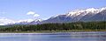
Rainy Lake in Lolo National Forest
-
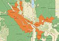
Map of Lolo National Forest
See also
- List of forests in Montana
