Seeley Lake, Montana facts for kids
Quick facts for kids
Seeley Lake, Montana
|
|
|---|---|
 |
|

Location in Missoula County and the state of Montana
|
|
| Country | United States |
| State | Montana |
| County | Missoula |
| Area | |
| • Total | 13.13 sq mi (34.00 km2) |
| • Land | 12.26 sq mi (31.75 km2) |
| • Water | 0.87 sq mi (2.25 km2) |
| Elevation | 4,019 ft (1,225 m) |
| Population
(2020)
|
|
| • Total | 1,682 |
| • Density | 137.21/sq mi (52.97/km2) |
| Time zone | UTC-7 (Mountain (MST)) |
| • Summer (DST) | UTC-6 (MDT) |
| ZIP code |
59868
|
| Area code(s) | 406 |
| FIPS code | 30-67150 |
| GNIS feature ID | 0799011 |
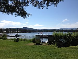
Seeley Lake is a small town in Missoula County, Montana, in the United States. It is located next to a large lake, also called Seeley Lake, which is about 1,030 acres big. In 2020, about 1,682 people lived here. Seeley Lake is considered part of the larger Missoula area.
| Top - 0-9 A B C D E F G H I J K L M N O P Q R S T U V W X Y Z |
History of Seeley Lake
The town of Seeley Lake gets its name from Jasper B. Seely. He built a cabin here in 1881, when the lake was known as Clearwater Lake. Jasper Seely was also the first park ranger for the Lewis and Clarke Forest Reserve. The first road leading to Seeley Lake was built in 1895, making it easier for people to visit and live there.
Geography and Location
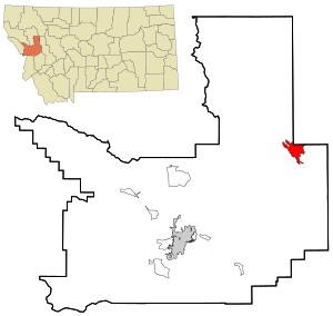
Seeley Lake is in the northeastern part of Missoula County. To its north, it shares a border with Powell County. The southern half of Seeley Lake, the actual body of water, is located in the northwest area of the town.
The Clearwater River flows out of Seeley Lake. It forms the southwest edge of the community. This river then flows south towards the Blackfoot River. Both are part of the Clark Fork River system.
Getting Around Seeley Lake
Montana Highway 83 goes right through Seeley Lake.
- If you go south on Highway 83 for about 14 miles, you'll reach Montana Highway 200 at Clearwater Junction.
- If you head north for about 74 miles, you'll get to Bigfork.
- The city of Missoula is about 52 miles southwest. You can get there by taking highways 83 and 200.
The total area of Seeley Lake is about 13.1 square miles (34.0 square kilometers). Most of this area, about 12.3 square miles (31.75 square kilometers), is land. The rest, about 0.9 square miles (2.25 square kilometers), is water.
Climate and Weather
Seeley Lake has a type of climate called a warm-summer humid continental climate. This means it has warm summers and cold, snowy winters.
Here are some interesting weather facts:
- The hottest temperature ever recorded in Seeley Lake was 102°F (39°C) on July 7, 2007.
- The coldest temperature ever recorded was a very chilly -53°F (-47°C) on January 7, 1937.
| Climate data for Seeley Lake, Montana, 1991–2020 normals, extremes 1936–present | |||||||||||||
|---|---|---|---|---|---|---|---|---|---|---|---|---|---|
| Month | Jan | Feb | Mar | Apr | May | Jun | Jul | Aug | Sep | Oct | Nov | Dec | Year |
| Record high °F (°C) | 55 (13) |
62 (17) |
73 (23) |
86 (30) |
93 (34) |
98 (37) |
102 (39) |
101 (38) |
96 (36) |
86 (30) |
66 (19) |
61 (16) |
102 (39) |
| Mean maximum °F (°C) | 44.5 (6.9) |
49.8 (9.9) |
59.3 (15.2) |
69.4 (20.8) |
80.4 (26.9) |
87.1 (30.6) |
93.6 (34.2) |
93.4 (34.1) |
88.3 (31.3) |
75.3 (24.1) |
54.5 (12.5) |
43.1 (6.2) |
95.2 (35.1) |
| Mean daily maximum °F (°C) | 32.0 (0.0) |
36.5 (2.5) |
45.1 (7.3) |
53.6 (12.0) |
64.5 (18.1) |
72.2 (22.3) |
83.2 (28.4) |
82.9 (28.3) |
72.8 (22.7) |
56.0 (13.3) |
39.6 (4.2) |
30.6 (−0.8) |
55.8 (13.2) |
| Daily mean °F (°C) | 22.0 (−5.6) |
24.7 (−4.1) |
32.5 (0.3) |
40.2 (4.6) |
49.4 (9.7) |
56.4 (13.6) |
63.7 (17.6) |
62.8 (17.1) |
54.6 (12.6) |
42.4 (5.8) |
30.5 (−0.8) |
21.8 (−5.7) |
41.8 (5.4) |
| Mean daily minimum °F (°C) | 12.1 (−11.1) |
12.8 (−10.7) |
19.9 (−6.7) |
26.8 (−2.9) |
34.2 (1.2) |
40.5 (4.7) |
44.3 (6.8) |
42.6 (5.9) |
36.5 (2.5) |
28.7 (−1.8) |
21.3 (−5.9) |
13.0 (−10.6) |
27.7 (−2.4) |
| Mean minimum °F (°C) | −18.2 (−27.9) |
−14.9 (−26.1) |
−0.5 (−18.1) |
15.3 (−9.3) |
23.1 (−4.9) |
30.3 (−0.9) |
35.3 (1.8) |
33.3 (0.7) |
26.1 (−3.3) |
13.3 (−10.4) |
1.6 (−16.9) |
−10.4 (−23.6) |
−27.1 (−32.8) |
| Record low °F (°C) | −53 (−47) |
−45 (−43) |
−42 (−41) |
−4 (−20) |
13 (−11) |
23 (−5) |
28 (−2) |
24 (−4) |
15 (−9) |
−10 (−23) |
−31 (−35) |
−44 (−42) |
−53 (−47) |
| Average precipitation inches (mm) | 2.63 (67) |
1.92 (49) |
1.44 (37) |
1.37 (35) |
1.88 (48) |
2.31 (59) |
1.07 (27) |
0.96 (24) |
1.19 (30) |
1.96 (50) |
2.52 (64) |
2.35 (60) |
21.60 (549) |
| Average snowfall inches (cm) | 30.4 (77) |
18.5 (47) |
15.2 (39) |
4.5 (11) |
0.7 (1.8) |
0.4 (1.0) |
0.0 (0.0) |
0.0 (0.0) |
0.0 (0.0) |
2.3 (5.8) |
18.0 (46) |
28.9 (73) |
118.9 (301.6) |
| Average extreme snow depth inches (cm) | 24.0 (61) |
26.0 (66) |
23.3 (59) |
7.9 (20) |
0.0 (0.0) |
0.0 (0.0) |
0.0 (0.0) |
0.0 (0.0) |
0.0 (0.0) |
1.3 (3.3) |
7.1 (18) |
15.7 (40) |
29.1 (74) |
| Average precipitation days (≥ 0.01 in) | 15.8 | 11.3 | 11.9 | 11.5 | 11.7 | 13.7 | 7.0 | 7.3 | 8.9 | 11.6 | 13.6 | 15.6 | 139.9 |
| Average snowy days (≥ 0.1 in) | 13.8 | 9.6 | 7.9 | 3.5 | 0.5 | 0.1 | 0.0 | 0.0 | 0.0 | 1.3 | 8.5 | 14.0 | 59.2 |
| Source 1: NOAA | |||||||||||||
| Source 2: National Weather Service | |||||||||||||
Impact of the Rice Ridge Fire
In the late summer of 2017, Seeley Lake was greatly affected by the Rice Ridge Fire. This large wildfire caused the air quality to become very unhealthy for a long time. Local officials even suggested that all residents should leave their homes for safety. Special aircraft called Super Scoopers were used to collect water from Seeley Lake to help fight the fire. Scientists are studying the long-term health effects of the smoke on the people who lived there.
Population and People
| Historical population | |||
|---|---|---|---|
| Census | Pop. | %± | |
| 2000 | 1,436 | — | |
| 2010 | 1,659 | 15.5% | |
| 2020 | 1,682 | 1.4% | |
| U.S. Decennial Census | |||
In 2010, there were 1,659 people living in Seeley Lake. These people lived in 589 households, and 411 of these were families. The population density was about 131.9 people per square mile.
Most of the people in Seeley Lake are White (96.94%). There are also smaller groups of Native American (1.46%), Asian (0.21%), and African American (0.07%) residents. About 1.46% of the population identified as Hispanic or Latino.
In terms of age, the population was spread out:
- 25.3% were under 18 years old.
- 5.2% were between 18 and 24.
- 28.3% were between 25 and 44.
- 29.5% were between 45 and 64.
- 11.8% were 65 years or older.
The average age in Seeley Lake was 41 years old.
Education in Seeley Lake
Children in Seeley Lake attend schools within two main districts:
- The Seeley Lake Elementary School District for younger students.
- The Missoula High School District for older students.
Seeley-Swan High School serves students from 9th to 12th grade. Their sports teams are known as the Blackhawks. The Missoula Public Library also has a branch located in Seeley Lake, offering books and resources to the community.
Local Media
The local newspaper for Seeley Lake is called the Seeley-Swan Pathfinder. It is published once a week, keeping residents informed about local news and events.
See also
 In Spanish: Seeley Lake para niños
 | Isaac Myers |
 | D. Hamilton Jackson |
 | A. Philip Randolph |


