Powell County, Montana facts for kids
Quick facts for kids
Powell County
|
|
|---|---|

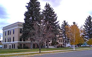
Powell County Courthouse, Deer Lodge
|
|

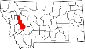
Location within the U.S. state of Montana
|
|
 Montana's location within the U.S. |
|
| Country | |
| State | |
| Founded | February 2, 1901 |
| Named for | Mount Powell, which was named in turn for John Wesley Powell |
| Seat | Deer Lodge |
| Largest city | Deer Lodge |
| Area | |
| • Total | 2,333 sq mi (6,040 km2) |
| • Land | 2,326 sq mi (6,020 km2) |
| • Water | 6.3 sq mi (16 km2) 0.3% |
| Population
(2020)
|
|
| • Total | 6,946 |
| • Estimate
(2022)
|
7,051 |
| • Density | 2.9773/sq mi (1.1495/km2) |
| Time zone | UTC−7 (Mountain) |
| • Summer (DST) | UTC−6 (MDT) |
| Congressional district | 1st |
|
|
Powell County is a county located in the state of Montana in the United States. It was founded on February 2, 1901. In 2020, about 6,946 people lived there. The main town and county seat is Deer Lodge. The county is named after Mount Powell, which itself was named for John Wesley Powell.
Contents
Exploring Powell County's Geography

Powell County is a large area in Montana. It covers about 2,332.7 square miles. Most of this area is land, with a small part being water.
Main Roads and Travel Routes
Many important roads help people travel through Powell County. These roads connect different towns and areas.
Neighboring Counties
Powell County shares its borders with several other counties in Montana.
- Flathead County (to the north)
- Lewis and Clark County (to the east)
- Jefferson County (to the southeast)
- Deer Lodge County (to the south)
- Granite County (to the southwest)
- Missoula County (to the west)
Protected Natural Areas
A big part of Powell County is covered by national forests and wilderness areas. These places help protect nature and wildlife.
- Beaverhead-Deerlodge National Forest (part of it)
- Flathead National Forest (part of it)
- Grant-Kohrs Ranch National Historic Site
- Helena National Forest (part of it)
- Lolo National Forest (part of it)
- Bob Marshall Wilderness Area (part of it)
- Scapegoat Wilderness Area (part of it)
People and Population in Powell County
| Historical population | |||
|---|---|---|---|
| Census | Pop. | %± | |
| 1910 | 5,904 | — | |
| 1920 | 6,909 | 17.0% | |
| 1930 | 6,202 | −10.2% | |
| 1940 | 6,152 | −0.8% | |
| 1950 | 6,301 | 2.4% | |
| 1960 | 7,002 | 11.1% | |
| 1970 | 6,660 | −4.9% | |
| 1980 | 6,958 | 4.5% | |
| 1990 | 6,620 | −4.9% | |
| 2000 | 7,180 | 8.5% | |
| 2010 | 7,027 | −2.1% | |
| 2020 | 6,946 | −1.2% | |
| 2022 (est.) | 7,051 | 0.3% | |
| U.S. Decennial Census 1790–1960, 1900–1990, 1990–2000, 2010–2020 |
|||
The number of people living in Powell County has changed over the years. In 2020, the population was 6,946.
Looking at the 2010 Census
In 2010, there were 7,027 people living in Powell County. Most people were white, and a small number were American Indian, Black, or Asian. About 1.7% of the population was of Hispanic or Latino origin.
Communities in Powell County
Powell County has one main city and several smaller towns and communities.
The City of Deer Lodge
- Deer Lodge is the largest city and the county seat. This means it's where the county government offices are located.
Other Towns and Places
These are smaller communities in Powell County:
Other Small Communities
Some other very small, unincorporated communities include:
- Carpenter's Bar
- Danielsville
- Jens
- Pioneer
- Wall City
Education in Powell County
Children in Powell County attend different elementary schools depending on where they live.
- Avon Elementary School District
- Deer Lodge Elementary School District
- Elliston Elementary School District
- Garrison Elementary School District
- Gold Creek Elementary School District
- Helmville Elementary School District
- Ovando Elementary School District
All students in the county attend the Powell County High School District for their high school education. The Deer Lodge School District includes both the elementary and high school districts for Deer Lodge.
See also
 In Spanish: Condado de Powell (Montana) para niños
 | John T. Biggers |
 | Thomas Blackshear |
 | Mark Bradford |
 | Beverly Buchanan |

