
Lewis and Clark County, Montana facts for kids
Quick facts for kids
Lewis and Clark County
|
||
|---|---|---|

The "Sleeping Giant" formation north of Helena
|
||
|
||

Location within the U.S. state of Montana
|
||
 Montana's location within the U.S. |
||
| Country | ||
| State | ||
| Founded | June 2, 1865 | |
| Named for | Meriwether Lewis and William Clark | |
| Seat | Helena | |
| Largest city | Helena | |
| Area | ||
| • Total | 3,498 sq mi (9,060 km2) | |
| • Land | 3,459 sq mi (8,960 km2) | |
| • Water | 39 sq mi (100 km2) 1.1% | |
| Population
(2020)
|
||
| • Total | 70,973 | |
| • Estimate
(2022)
|
73,832 |
|
| • Density | 20.2896/sq mi (7.8339/km2) | |
| Time zone | UTC−7 (Mountain) | |
| • Summer (DST) | UTC−6 (MDT) | |
| Congressional district | 2nd | |
|
||

Lewis and Clark County is a county in Montana, a state in the United States. In 2020, about 70,973 people lived here. The main city and county seat is Helena, which is also the capital of Montana. The county was first created on June 2, 1865. It was named Edgerton County after Sidney Edgerton, the first governor of the Montana Territory. Later, on March 1, 1868, its name was changed to Lewis and Clark County. This was to honor the famous explorers Meriwether Lewis and William Clark. Lewis and Clark County is part of the Helena, Montana area.
Contents
Geography of Lewis and Clark County
Lewis and Clark County covers a total area of about 3,498 square miles. Most of this area is land, about 3,459 square miles. The rest, about 39 square miles, is water.
Main Roads in the County
These are the major highways that pass through Lewis and Clark County:
 Interstate 15
 U.S. Highway 12
 U.S. Highway 287
 Montana Highway 21
 Montana Highway 200
Neighboring Counties
Lewis and Clark County shares borders with several other counties:
- Teton County to the north
- Cascade County to the east
- Meagher County to the east
- Broadwater County to the southeast
- Jefferson County to the south
- Powell County to the west
- Flathead County to the northwest
Protected Natural Areas
Parts of these national protected areas are found within Lewis and Clark County:
- Flathead National Forest
- Helena National Forest
- Lewis and Clark National Forest
- Lolo National Forest
- Rocky Mountain Front Conservation Area
Population of Lewis and Clark County
| Historical population | |||
|---|---|---|---|
| Census | Pop. | %± | |
| 1870 | 5,040 | — | |
| 1880 | 6,521 | 29.4% | |
| 1890 | 19,145 | 193.6% | |
| 1900 | 19,171 | 0.1% | |
| 1910 | 21,853 | 14.0% | |
| 1920 | 18,660 | −14.6% | |
| 1930 | 18,224 | −2.3% | |
| 1940 | 22,131 | 21.4% | |
| 1950 | 24,540 | 10.9% | |
| 1960 | 28,006 | 14.1% | |
| 1970 | 33,281 | 18.8% | |
| 1980 | 43,039 | 29.3% | |
| 1990 | 47,495 | 10.4% | |
| 2000 | 55,716 | 17.3% | |
| 2010 | 63,395 | 13.8% | |
| 2020 | 70,973 | 12.0% | |
| 2022 (est.) | 73,832 | 16.5% | |
| U.S. Decennial Census 1790–1960, 1900–1990, 1990–2000, 2010–2020 |
|||
In 2020, the census counted 70,973 people living in Lewis and Clark County. In 2010, there were 63,395 people. About 28.8% of households had children under 18 living with them. The average age of people in the county was 40.9 years.
Communities in Lewis and Clark County
Lewis and Clark County has several towns and communities.
Cities
- Helena (This is the county seat)
Towns
Census-Designated Places
These are areas that are like towns but are not officially incorporated as cities or towns:
Other Unincorporated Communities
These are smaller communities that are not officially part of a city or town:
- Canyon Creek
- Silver City
- Unionville
- Wolf Creek
Ghost Towns
- Rimini (A ghost town is a place where most people have left)
Education in Lewis and Clark County
The county has several school districts for students of all ages.
Schools for All Grades (K-12)
- East Helena K-12 Schools
- Lincoln K-12 Schools
High Schools
- Augusta High School District
- Helena High School District
Elementary Schools
- Auchard Creek Elementary School District
- Augusta Elementary School District
- Helena Elementary School District
- Trinity Elementary School District
- Wolf Creek Elementary School District
Notable People from Lewis and Clark County
Many interesting people have connections to Lewis and Clark County:
- Seth Bullock: He was a sheriff in Lewis and Clark County. Later, he became a sheriff in Deadwood, South Dakota.
- Ted Kaczynski: He lived in a cabin near Lincoln from 1971 to 1996.
- Mike McGrath: He is the Chief Justice of the Montana Supreme Court. He also used to be the Attorney General for Montana and the County Attorney for Lewis and Clark County.
- Johnny Miljus: A professional baseball pitcher, he retired and lived in Fort Harrison in Lewis and Clark County.
- W. A. Boyle: He was the president of the UMW. He was born in Bald Butte, near Marysville.
- Brian Knight: He is a Major League Baseball umpire.
- The governor of Montana: The official home of Montana's governor is in Helena, the state capital.
Images for kids
-
The official seal of Lewis and Clark County.
-
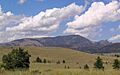
The "Sleeping Giant" rock formation, located north of Helena.
See also
 In Spanish: Condado de Lewis and Clark para niños
