Cascade County, Montana facts for kids
Quick facts for kids
Cascade County
|
|
|---|---|

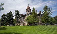
Cascade County Courthouse
|
|

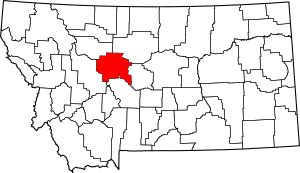
Location within the U.S. state of Montana
|
|
 Montana's location within the U.S. |
|
| Country | |
| State | |
| Founded | 1887 |
| Named for | Great Falls of the Missouri River |
| Seat | Great Falls |
| Largest city | Great Falls |
| Area | |
| • Total | 2,711 sq mi (7,020 km2) |
| • Land | 2,698 sq mi (6,990 km2) |
| • Water | 13 sq mi (30 km2) 0.5% |
| Population
(2020)
|
|
| • Total | 84,414 |
| • Estimate
(2022)
|
84,864 |
| • Density | 31.138/sq mi (12.0223/km2) |
| Time zone | UTC−7 (Mountain) |
| • Summer (DST) | UTC−6 (MDT) |
| Congressional district | 2nd |
|
|

Cascade County is a county in Montana, a state in the United States. The word cascade means waterfall in French. This county is named after the beautiful waterfalls on the Missouri River.
As of the 2020 census, about 84,414 people lived here. This makes it the fifth-most populated county in Montana. The main city and county seat (where the county government is) is Great Falls. Cascade County is also part of the Great Falls Metropolitan Statistical Area.
Contents
History of Cascade County
When the famous Lewis and Clark Expedition explored this area, Cascade County was home to the Blackfeet people. The county got its name from the impressive falls along the Missouri River.
The United States Army once had a military outpost called Fort Shaw in the northwest part of the county. Today, only a small community, known as a CDP, remains there.
Geography of Cascade County
Cascade County covers a total area of about 2,711 square miles. Most of this area, 2,698 square miles, is land. The remaining 13 square miles, or 0.5%, is water.
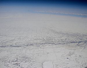
Two important rivers, the Missouri River and the Sun River, flow through the county. They meet near the city of Great Falls. You can also find parts of the Rocky Mountains in the western area. The Little Belt and Highwood Mountains are in the southeast.
Neighboring Counties
- Teton County - northwest
- Chouteau County - northeast
- Judith Basin County - east
- Meagher County - south
- Lewis and Clark County - west
Protected Natural Areas
Cascade County is home to some special protected areas. These include:
- Benton Lake National Wildlife Refuge
- Part of the Lewis and Clark National Forest
Population and People
| Historical population | |||
|---|---|---|---|
| Census | Pop. | %± | |
| 1890 | 8,755 | — | |
| 1900 | 25,777 | 194.4% | |
| 1910 | 28,833 | 11.9% | |
| 1920 | 38,836 | 34.7% | |
| 1930 | 41,146 | 5.9% | |
| 1940 | 41,199 | 0.1% | |
| 1950 | 53,027 | 28.7% | |
| 1960 | 73,418 | 38.5% | |
| 1970 | 81,804 | 11.4% | |
| 1980 | 80,696 | −1.4% | |
| 1990 | 77,691 | −3.7% | |
| 2000 | 80,357 | 3.4% | |
| 2010 | 81,327 | 1.2% | |
| 2020 | 84,414 | 3.8% | |
| 2022 (est.) | 84,864 | 4.3% | |
| U.S. Decennial Census 1790–1960, 1900–1990, 1990–2000, 2010–2020 |
|||
Recent Population Counts
According to the 2020 census, there were 84,414 people living in Cascade County. In the 2010 census, the population was 81,327 people.
Economy of Cascade County
A big part of the local economy is Malmstrom Air Force Base. It provides many jobs in the area. Other large employers in 2009 included Benefis, Great Falls Clinic, National Electronics Warranty, and Walmart.
Education in Cascade County
Great Falls is home to several colleges and universities. These include Apollos University, the University of Great Falls, and the MSU College of Technology—Great Falls.
Schools for Kids
There are many public school districts for students from kindergarten to 12th grade.
Secondary (High School) Districts:
- Belt High School District
- Cascade High School District
- Great Falls High School District
- Simms High School District
- Centerville High School District
Elementary School Districts:
- Belt Elementary School District
- Centerville Elementary School District
- Cascade Elementary School District
- Great Falls Elementary School District
- Sun River Valley Elementary School District
- Ulm Elementary School District
- Vaughn Elementary School District
There is also a special state-run school called the Montana School for the Deaf & Blind.
Communities in Cascade County
Cities
- Great Falls (This is the county seat)
Towns
Census-Designated Places (CDPs)
- Big Stone Colony
- Black Eagle
- Cascade Colony
- Centerville
- Fair Haven Colony
- Fort Shaw
- Gibson Flats
- Hardy
- Malmstrom AFB
- Monarch
- Pleasant Valley Colony
- Riceville
- Sand Coulee
- Simms
- Stockett
- Sun Prairie
- Sun River
- Tracy
- Ulm
- Vaughn
Other Communities (Unincorporated)
- Adel
- Armington
- Armington Junction
- Ashuelot
- Dearborn (partially in Lewis & Clark County)
- Eden
- Emerson Junction
- Gordon
- Millegan
- Number Seven
- Salem
- Sheffels
- Portage
See also
 In Spanish: Condado de Cascade para niños
 | Delilah Pierce |
 | Gordon Parks |
 | Augusta Savage |
 | Charles Ethan Porter |

