Judith Basin County, Montana facts for kids
Quick facts for kids
Judith Basin County
|
|
|---|---|

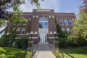
Judith Basin County Courthouse in Stanford
|
|

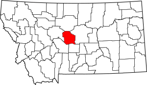
Location within the U.S. state of Montana
|
|
 Montana's location within the U.S. |
|
| Country | |
| State | |
| Founded | December 10, 1920 |
| Seat | Stanford |
| Largest town | Stanford |
| Area | |
| • Total | 1,871 sq mi (4,850 km2) |
| • Land | 1,870 sq mi (4,800 km2) |
| • Water | 0.8 sq mi (2 km2) 0.04% |
| Population
(2020)
|
|
| • Total | 2,023 |
| • Estimate
(2022)
|
2,105 |
| • Density | 1.0/sq mi (0.4/km2) |
| Time zone | UTC−7 (Mountain) |
| • Summer (DST) | UTC−6 (MDT) |
| Congressional district | 2nd |
|
|
Judith Basin County is a county located in the state of Montana in the United States. As of the 2020 census, about 2,023 people lived there. The main town and county seat (where the county government is) is Stanford.
Contents
History of Judith Basin County
Judith Basin County was created on December 10, 1920. It was formed from parts of two other counties: western Fergus County and eastern Cascade County.
An interesting event happened in 1895. Special blue gemstones called Yogo sapphires were found at a place called Yogo Gulch. This spot is about 15 miles southwest of Utica, which was part of Fergus County at the time.
Geography of Judith Basin County
Judith Basin County covers a total area of about 1,871 square miles. Most of this area, around 1,870 square miles, is land. Only a very small part, about 0.8 square miles, is water.
Neighboring Counties
Judith Basin County shares borders with several other counties:
- Chouteau County to the north
- Fergus County to the east
- Wheatland County to the south
- Meagher County to the south
- Cascade County to the west
Protected Natural Areas
Part of the Lewis and Clark National Forest is located within Judith Basin County. This is a large area of protected land.
Towns and Communities
Here are some of the places where people live in Judith Basin County:
City
Town
- Stanford (This is the county seat)
Census-Designated Places
These are areas that are like towns but are not officially incorporated as cities or towns.
- Geyser
- Moccasin
- Raynesford
- Sapphire Ridge
- Surprise Creek Colony
- Utica
- Windham
Other Communities
These are smaller, unincorporated communities.
- Arrow Creek
- Benchland
- Hughesville
- Kolin
- Lehigh
- Sapphire Village
- Sipple
- Spion Kop
- Utica
Former Town
Population and People
| Historical population | |||
|---|---|---|---|
| Census | Pop. | %± | |
| 1930 | 5,238 | — | |
| 1940 | 3,655 | −30.2% | |
| 1950 | 3,200 | −12.4% | |
| 1960 | 3,085 | −3.6% | |
| 1970 | 2,667 | −13.5% | |
| 1980 | 2,646 | −0.8% | |
| 1990 | 2,282 | −13.8% | |
| 2000 | 2,329 | 2.1% | |
| 2010 | 2,072 | −11.0% | |
| 2020 | 2,023 | −2.4% | |
| 2022 (est.) | 2,105 | 1.6% | |
| U.S. Decennial Census 1790–1960, 1900–1990, 1990–2000, 2010–2020 |
|||
The population of Judith Basin County has changed over the years. The table above shows how many people lived there during different census years.
2020 Census Information
In 2020, the census showed that 2,023 people lived in Judith Basin County.
2010 Census Information
According to the 2010 census, there were 2,072 people living in the county. These people lived in 924 households, and 600 of these were families.
Most of the people in the county were white (98.3%). About 0.8% were American Indian, and smaller numbers were Asian or from other backgrounds. About 1.2% of the population was of Hispanic or Latino origin.
Many people in the county have ancestors from different parts of Europe. For example, 30.9% had German ancestry, 16.7% had English ancestry, and 16.1% had Irish ancestry.
About 24% of the households had children under 18 living with them. The average household had about 2.24 people. The average age of people in the county was 48.3 years old.
See also
- Condado de Judith Basin para niños (In Spanish)
 | Aaron Henry |
 | T. R. M. Howard |
 | Jesse Jackson |

