
Wheatland County, Montana facts for kids
Quick facts for kids
Wheatland County
|
|
|---|---|

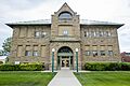
Wheatland County Courthouse in Harlowton
|
|

Location within the U.S. state of Montana
|
|
 Montana's location within the U.S. |
|
| Country | |
| State | |
| Founded | February 22, 1917 |
| Named for | wheat growing |
| Seat | Harlowton |
| Largest city | Harlowton |
| Area | |
| • Total | 1,428 sq mi (3,700 km2) |
| • Land | 1,423 sq mi (3,690 km2) |
| • Water | 5.0 sq mi (13 km2) 0.4% |
| Population
(2020)
|
|
| • Total | 2,069 |
| • Estimate
(2022)
|
2,032 |
| • Density | 1.4489/sq mi (0.5594/km2) |
| Time zone | UTC−7 (Mountain) |
| • Summer (DST) | UTC−6 (MDT) |
| Congressional district | 2nd |
|
|
Wheatland County is a county located in the state of Montana in the United States. As of the 2020 census, about 2,069 people lived there. The main town and government center of the county is Harlowton.
Wheatland County was created on February 22, 1917. It was formed from parts of Meagher and Sweet Grass counties. The county got its name because a lot of wheat grows in the central part of the area.
Contents
Exploring Wheatland County's Geography
This section helps you understand the land and features of Wheatland County.
Land and Water Areas
According to the United States Census Bureau, Wheatland County covers a total area of about 1,428 square miles. Most of this, about 1,423 square miles, is land. The remaining 5.0 square miles, which is about 0.4% of the total area, is water.
Important Roads and Highways
Major highways are important roads that connect different towns and areas. They help people travel and transport goods across the county and beyond.
 U.S. Highway 12
 U.S. Highway 191
 Montana Highway 3
Neighboring Counties
Wheatland County shares its borders with several other counties. These are its neighbors:
- Judith Basin County - to the north
- Fergus County - to the north
- Golden Valley County - to the east
- Sweet Grass County - to the south
- Meagher County - to the west
Protected Natural Areas
Part of a large national forest is located within Wheatland County.
- Lewis and Clark National Forest (part)
Understanding Wheatland County's Population
This section looks at how many people live in Wheatland County and what the population is like.
Population Changes Over Time
The number of people living in Wheatland County has changed over many years. Here's how the population has looked during different census counts:
| Historical population | |||
|---|---|---|---|
| Census | Pop. | %± | |
| 1920 | 5,619 | — | |
| 1930 | 3,751 | −33.2% | |
| 1940 | 3,286 | −12.4% | |
| 1950 | 3,187 | −3.0% | |
| 1960 | 3,026 | −5.1% | |
| 1970 | 2,529 | −16.4% | |
| 1980 | 2,359 | −6.7% | |
| 1990 | 2,246 | −4.8% | |
| 2000 | 2,259 | 0.6% | |
| 2010 | 2,168 | −4.0% | |
| 2020 | 2,069 | −4.6% | |
| 2022 (est.) | 2,032 | −6.3% | |
| U.S. Decennial Census 1790–1960, 1900–1990, 1990–2000, 2010–2020 |
|||
Recent Population Counts
The United States census counts how many people live in an area every ten years.
- As of the 2020 census, there were 2,069 people living in Wheatland County.
- In the 2010 census, there were 2,168 people. About 887 households and 538 families lived in the county.
- The population density was about 1.5 people per square mile. This means the county is not very crowded.
- Most people in the county were white (95.8%). Smaller groups included Asian, American Indian, and Black or African American people. About 1.5% of the population was of Hispanic or Latino background.
- Many people had ancestors from Germany (22.7%), England (14.1%), Ireland (11.5%), and Norway (6.6%). About 35.2% said their ancestry was American.
Households and Families
In 2010, about 23.7% of households had children under 18 living with them. About half of the households (50.8%) were married couples living together. The average household had 2.28 people, and the average family had 2.99 people. The average age of people in the county was 44.9 years old.
Towns and Places in Wheatland County
Wheatland County has several communities, including cities and smaller towns.
Cities in Wheatland County
- Harlowton (This is the county seat, where the main government offices are.)
- Judith Gap
Census-Designated Places (CDPs)
These are areas that are like towns but are not officially incorporated as cities.
Other Small Communities
These are even smaller places that are not officially incorporated.
- Hedgesville
- Living Springs
Images for kids
-
Wheatland County Courthouse in Harlowton
See also
 In Spanish: Condado de Wheatland para niños
