Golden Valley County, Montana facts for kids
Quick facts for kids
Golden Valley County
|
|
|---|---|

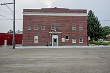
Golden Valley County Courthouse in Ryegate, Montana
|
|

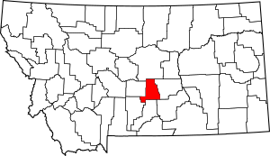
Location within the U.S. state of Montana
|
|
 Montana's location within the U.S. |
|
| Country | |
| State | |
| Founded | March 8, 1920 |
| Seat | Ryegate |
| Largest town | Ryegate |
| Area | |
| • Total | 1,176 sq mi (3,050 km2) |
| • Land | 1,175 sq mi (3,040 km2) |
| • Water | 1.0 sq mi (3 km2) 0.08% |
| Population
(2020)
|
|
| • Total | 823 |
| • Estimate
(2022)
|
831 |
| • Density | 0.6998/sq mi (0.27021/km2) |
| Time zone | UTC−7 (Mountain) |
| • Summer (DST) | UTC−6 (MDT) |
| Congressional district | 2nd |
|
|
Golden Valley County is a small but interesting county in the state of Montana. It was created on March 8, 1920. The county is named for the beautiful golden fields of grain that grow there.
As of the 2020 census, about 823 people lived in Golden Valley County. This makes it one of the least populated counties in Montana. The main town and county seat is Ryegate.
Contents
Geography of Golden Valley County
Golden Valley County is located in the central part of Montana. It covers a total area of about 1,176 square miles. Most of this area is land, with only a small amount of water. It is the fifth-smallest county in Montana by size.
Main Roads
You can travel through Golden Valley County using these important roads:
Neighboring Counties
Golden Valley County shares its borders with several other counties:
- Fergus County to the north
- Musselshell County to the east
- Yellowstone County to the southeast
- Stillwater County to the south
- Sweet Grass County to the southwest
- Wheatland County to the west
Protected Natural Areas
Part of the Lewis and Clark National Forest is located within Golden Valley County. This is a large area of protected land. It is important for nature and wildlife.
People of Golden Valley County
| Historical population | |||
|---|---|---|---|
| Census | Pop. | %± | |
| 1930 | 2,126 | — | |
| 1940 | 1,607 | −24.4% | |
| 1950 | 1,337 | −16.8% | |
| 1960 | 1,203 | −10.0% | |
| 1970 | 931 | −22.6% | |
| 1980 | 1,026 | 10.2% | |
| 1990 | 912 | −11.1% | |
| 2000 | 1,042 | 14.3% | |
| 2010 | 884 | −15.2% | |
| 2020 | 823 | −6.9% | |
| 2022 (est.) | 835 | −5.5% | |
| U.S. Decennial Census 1790–1960 1900–1990 1990–2000 2010–2020 |
|||
The population of Golden Valley County has changed over the years. The numbers above show how many people lived there during different census counts. A census is like a big count of everyone living in a country.
What the 2020 Census Shows
In 2020, the census counted 823 people living in Golden Valley County.
What the 2010 Census Showed
Back in 2010, there were 884 people living in the county. They lived in 363 homes. Most people in the county were white. Some people also had Native American, Asian, or other backgrounds. About 3.5% of the people were of Hispanic or Latino origin.
Many families in Golden Valley County have German, English, or Irish roots. Other backgrounds include Polish, American, Danish, Dutch, and Norwegian.
Communities in Golden Valley County
Golden Valley County has a few towns and communities.
Towns
Census-Designated Place
- Golden Valley Colony is a special type of community. It is counted by the census but is not an official town.
Other Small Communities
These are smaller places that are not officially organized as towns:
- Barber
- Belmont
- Franklin
- Lavina
See also
 In Spanish: Condado de Golden Valley (Montana) para niños
 | Jackie Robinson |
 | Jack Johnson |
 | Althea Gibson |
 | Arthur Ashe |
 | Muhammad Ali |

