
Sweet Grass County, Montana facts for kids
Quick facts for kids
Sweet Grass County
|
|
|---|---|

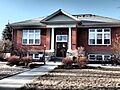
Carnegie library designed by Link & Haire in Big Timber, Montana
|
|

Location within the U.S. state of Montana
|
|
 Montana's location within the U.S. |
|
| Country | |
| State | |
| Founded | 1895 |
| Named for | Sweet grass |
| Seat | Big Timber |
| Largest city | Big Timber |
| Area | |
| • Total | 1,862 sq mi (4,820 km2) |
| • Land | 1,855 sq mi (4,800 km2) |
| • Water | 6.8 sq mi (18 km2) 0.4% |
| Population
(2020)
|
|
| • Total | 3,678 |
| • Estimate
(2022)
|
3,715 |
| • Density | 1.9753/sq mi (0.76267/km2) |
| Time zone | UTC−7 (Mountain) |
| • Summer (DST) | UTC−6 (MDT) |
| Congressional district | 2nd |
|
|
Sweet Grass County is a place in the state of Montana, USA. It is named after a type of plant called sweet grass. As of 2020, about 3,678 people live here. The main town and county seat is Big Timber. The county was created in 1895.
Contents
History of Sweet Grass County
Sweet Grass County was officially formed in 1895. It was created from parts of three other counties: Park, Meagher, and Yellowstone.
Over the years, the county's borders changed a few times. In 1913, a new county called Stillwater County was made from some of Sweet Grass County's land. Later, in 1917, Wheatland County was formed, and in 1920, Golden Valley County was also created from parts of Sweet Grass County.
Climate and Weather
Sweet Grass County usually has dry and cool weather. It gets about 15 inches of rain and snow each year. Most of this rain falls between April and September.
In summer, from April to September, the average high temperature is around 75 degrees Fahrenheit (24°C). The average low temperature during this time is about 44 degrees Fahrenheit (7°C). July and August are the warmest months.
Throughout the whole year, the average high temperature is about 61 degrees Fahrenheit (16°C). The average low is around 34 degrees Fahrenheit (1°C). The coldest temperature ever recorded here was -47 degrees Fahrenheit (-44°C) in 1936. The warmest was 107 degrees Fahrenheit (42°C) in 2002. The town of Big Timber gets about 286 sunny days each year!
Geography of the County
Sweet Grass County covers a total area of about 1,862 square miles. Most of this area, about 1,855 square miles, is land. Only a small part, about 6.8 square miles, is water.
Main Roads and Highways
You can travel through Sweet Grass County on these important roads:
 Interstate 90
 U.S. Highway 191
 U.S. Highway 10 (This road used to be a main highway here.)
Public Transportation
- Jefferson Lines provides bus service in the area.
Neighboring Counties
Sweet Grass County shares its borders with several other counties:
- Wheatland County to the north
- Golden Valley County to the northeast
- Stillwater County to the east
- Park County to the west
- Meagher County to the northwest
Protected Natural Areas
Parts of these large national forests are located in Sweet Grass County:
- Custer National Forest
- Gallatin National Forest
- Lewis and Clark National Forest
Population and People
| Historical population | |||
|---|---|---|---|
| Census | Pop. | %± | |
| 1900 | 3,086 | — | |
| 1910 | 4,029 | 30.6% | |
| 1920 | 4,926 | 22.3% | |
| 1930 | 3,944 | −19.9% | |
| 1940 | 3,719 | −5.7% | |
| 1950 | 3,621 | −2.6% | |
| 1960 | 3,290 | −9.1% | |
| 1970 | 2,980 | −9.4% | |
| 1980 | 3,216 | 7.9% | |
| 1990 | 3,154 | −1.9% | |
| 2000 | 3,609 | 14.4% | |
| 2010 | 3,651 | 1.2% | |
| 2020 | 3,678 | 0.7% | |
| 2022 (est.) | 3,715 | 1.8% | |
| U.S. Decennial Census 1790–1960, 1900–1990, 1990–2000, 2010–2020 |
|||
As of the 2020 census, 3,678 people lived in Sweet Grass County. The population has changed over the years, as you can see in the chart above.
In 2010, most people living in the county were white. A small number of people were of Asian or American Indian background. People from Hispanic or Latino backgrounds made up a small part of the population. Many families in the county were married couples. The average age of people living here was about 46.6 years old.
Culture and Films
Sweet Grass County was the setting for a movie called Sweetgrass. This documentary film, made in 2009, is about sheep herding. Even though the movie takes place in many parts of Montana, it was named after this county.
Towns and Communities
Sweet Grass County has one main city and several smaller communities.
City
- Big Timber is the largest city and the county seat. This means it's where the county government is located.
Census-Designated Place
- Greycliff is a community that the government counts for population, but it's not an officially organized city or town.
Other Communities
These are smaller, unincorporated communities in the county:
Images for kids
-
The Carnegie Public Library in Big Timber.
See also
 In Spanish: Condado de Sweet Grass para niños
