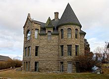
Meagher County, Montana facts for kids
Quick facts for kids
Meagher County
|
|
|---|---|

|
|

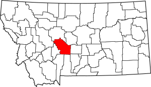
Location within the U.S. state of Montana
|
|
 Montana's location within the U.S. |
|
| Country | |
| State | |
| Founded | November 16, 1867 |
| Named for | Thomas Francis Meagher |
| Seat | White Sulphur Springs |
| Largest city | White Sulphur Springs |
| Area | |
| • Total | 2,395 sq mi (6,200 km2) |
| • Land | 2,392 sq mi (6,200 km2) |
| • Water | 2.8 sq mi (7 km2) 0.1% |
| Population
(2020)
|
|
| • Total | 1,927 |
| • Estimate
(2022)
|
2,013 |
| • Density | 0.8046/sq mi (0.31066/km2) |
| Time zone | UTC−7 (Mountain) |
| • Summer (DST) | UTC−6 (MDT) |
| Congressional district | 2nd |
|
|
Meagher County is a county in the state of Montana. A county is like a smaller area within a state, often with its own local government. In 2020, about 1,927 people lived here. The main town, or county capital, is White Sulphur Springs.
This county is also known for being the geographic center of Montana. This means it's the middle point of the entire state.
Contents
History of Meagher County
Meagher County was named after Thomas Francis Meagher. He was an important person in Montana's early history, serving as a territorial governor.
The first county capital was a place called Diamond City. This city was a big mining area. Today, Diamond City is no longer part of Meagher County. It is now in a nearby county called Broadwater County.
Geography and Nature
Meagher County covers a total area of about 2,395 square miles. Most of this area, about 2,392 square miles, is land. The rest, about 2.8 square miles, is water.
Main Roads in Meagher County
These are the major highways that pass through Meagher County:
Neighboring Counties
Meagher County shares borders with these other counties:
- Cascade County - to the north
- Judith Basin County - to the northeast
- Wheatland County - to the east
- Sweet Grass County - to the southeast
- Park County - to the south
- Gallatin County - to the south
- Broadwater County - to the west
- Lewis and Clark County - to the northwest
Protected Natural Areas
Parts of these large forests are located within Meagher County:
- Gallatin National Forest
- Helena National Forest
- Lewis and Clark National Forest
Population and People
| Historical population | |||
|---|---|---|---|
| Census | Pop. | %± | |
| 1870 | 1,387 | — | |
| 1880 | 2,743 | 97.8% | |
| 1890 | 4,749 | 73.1% | |
| 1900 | 2,526 | −46.8% | |
| 1910 | 4,190 | 65.9% | |
| 1920 | 2,622 | −37.4% | |
| 1930 | 2,272 | −13.3% | |
| 1940 | 2,237 | −1.5% | |
| 1950 | 2,079 | −7.1% | |
| 1960 | 2,616 | 25.8% | |
| 1970 | 2,122 | −18.9% | |
| 1980 | 2,154 | 1.5% | |
| 1990 | 1,819 | −15.6% | |
| 2000 | 1,932 | 6.2% | |
| 2010 | 1,891 | −2.1% | |
| 2020 | 1,927 | 1.9% | |
| 2022 (est.) | 2,013 | 6.5% | |
| U.S. Decennial Census 1790–1960, 1900–1990, 1990–2000, 2010–2020 |
|||
Population in 2020
According to the 2020 census, there were 1,927 people living in Meagher County.
Population in 2010
In the 2010 census, the county had 1,891 people. There were 806 households, which are groups of people living together.
Towns and Communities
City
- White Sulphur Springs (This is the county capital)
Census-Designated Places
These are areas that are like towns but are not officially incorporated as cities:
- Martinsdale
- Springdale Colony
Other Small Communities
These are other small, unincorporated places in the county:
- Castle Town
- Checkerboard
- Copperopolis
- Fort Logan
- Hamen
- Lennep
- Loweth
- Minden
- Moss Agate
- Moyne
- Ringling
- Sixteen
Individual Homes
- Ford Place
See also
 In Spanish: Condado de Meagher para niños
 | DeHart Hubbard |
 | Wilma Rudolph |
 | Jesse Owens |
 | Jackie Joyner-Kersee |
 | Major Taylor |

