Gallatin County, Montana facts for kids
Quick facts for kids
Gallatin County
|
||
|---|---|---|

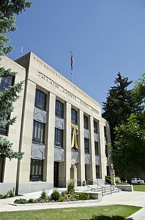
Gallatin County Courthouse in Bozeman
|
||
|
||

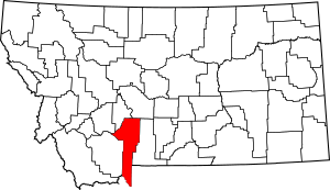
Location within the U.S. state of Montana
|
||
 Montana's location within the U.S. |
||
| Country | ||
| State | ||
| Founded | 1865 | |
| Named for | Gallatin River (Albert Gallatin) | |
| Seat | Bozeman | |
| Largest city | Bozeman | |
| Area | ||
| • Total | 2,632 sq mi (6,820 km2) | |
| • Land | 2,603 sq mi (6,740 km2) | |
| • Water | 29 sq mi (80 km2) 1.1% | |
| Population
(2020)
|
||
| • Total | 118,960 | |
| • Estimate
(2022)
|
124,938 |
|
| • Density | 45.198/sq mi (17.451/km2) | |
| Time zone | UTC−7 (Mountain) | |
| • Summer (DST) | UTC−6 (MDT) | |
| Congressional district | 1st | |
|
||
Gallatin County is a special area, like a big district, in the state of Montana. Its main town, called the county seat, is Bozeman. It is the second-most populated county in Montana. In 2020, about 118,960 people lived here.
The county has amazing natural features. You can see the Bridger Mountains in the north. To the south are the Gallatin Mountains and the Gallatin River. Meriwether Lewis named the river in 1805. He named it after Albert Gallatin, who was a very important government official at the time. Gallatin helped plan the famous Lewis and Clark Expedition.
A big part of Yellowstone National Park is close to Gallatin County. The entrance at West Yellowstone brings many visitors to the park. Also, Big Sky Resort is partly in Gallatin County. It is one of the biggest ski resorts in the United States. Big Sky is located between Bozeman and West Yellowstone.
Contents
History of Gallatin County
During the early days of Montana, there was a small piece of land called "Lost Dakota." This land was part of Dakota Territory, far away from the rest of it. In 1873, Lost Dakota became part of Gallatin County, Montana.
Exploring Gallatin County's Geography
Gallatin County covers a large area. It has about 2,632 square miles in total. Most of this is land (2,603 square miles), and a small part is water (29 square miles).
The county's borders changed in 1978. A part of Yellowstone National Park that was its own special area was split up. It was divided between Gallatin County and Park County. This change added more land and water to Gallatin County.
Main Roads in Gallatin County
Many important roads run through Gallatin County. These roads help people travel around the county and connect to other places.
 Interstate 90
 U.S. Highway 20
 U.S. Highway 191
 U.S. Highway 287
 Montana Highway 2
 Montana Highway 64
 Montana Highway 84
 Montana Highway 85
 Montana Highway 86
 Montana Secondary Highway 205
Nearby Counties
Gallatin County shares its borders with several other counties. Some are in Montana, and others are in neighboring states.
- Madison County - to the west
- Jefferson County - to the northwest
- Broadwater County - to the north
- Meagher County - to the northeast
- Park County - to the east
- Park County, Wyoming - to the southeast
- Teton County, Wyoming - to the southeast
- Fremont County, Idaho - to the southwest
Protected Natural Areas
Parts of two important protected areas are in Gallatin County:
- Gallatin National Forest
- Yellowstone National Park
People of Gallatin County
The number of people living in Gallatin County has grown a lot over the years.
| Historical population | |||
|---|---|---|---|
| Census | Pop. | %± | |
| 1870 | 1,578 | — | |
| 1880 | 3,643 | 130.9% | |
| 1890 | 6,246 | 71.5% | |
| 1900 | 9,553 | 52.9% | |
| 1910 | 14,079 | 47.4% | |
| 1920 | 15,864 | 12.7% | |
| 1930 | 16,124 | 1.6% | |
| 1940 | 18,269 | 13.3% | |
| 1950 | 21,902 | 19.9% | |
| 1960 | 26,045 | 18.9% | |
| 1970 | 32,505 | 24.8% | |
| 1980 | 42,865 | 31.9% | |
| 1990 | 50,463 | 17.7% | |
| 2000 | 67,831 | 34.4% | |
| 2010 | 89,513 | 32.0% | |
| 2020 | 118,960 | 32.9% | |
| 2022 (est.) | 124,938 | 39.6% | |
| U.S. Decennial Census 1790–1960, 1900–1990, 1990–2000, 2010–2020 |
|||
2020 Census Information
In 2020, the census counted 118,960 people in Gallatin County. There were also 46,990 households. A household is a group of people living together. The average family size was about three people.
Most people in the county (89%) were White. Other groups included Asian, American Indian, and Black or African American people. About 5% of the population was of Hispanic or Latino background. The average age of people in the county was 33.1 years old.
The average income for a household in Gallatin County was about $75,418. This was higher than the average income for all of Montana. About 11.9% of the people lived below the poverty line. This means they had a very low income.
Communities in Gallatin County
Gallatin County has several towns and cities. Each one has its own unique feel.
Cities
- Belgrade
- Bozeman (This is the county seat, the main town)
- Three Forks
Towns
Other Communities
There are also many smaller communities and places where people live. These are called census-designated places or unincorporated communities.
- Amsterdam
- Big Sky
- Bridger
- Churchill
- Four Corners
- Gallatin Gateway
- Gallatin River Ranch
- Hebgen Lake Estates
- King Arthur Park
- Logan
- Ponderosa Pines
- Sedan
- Springhill
- Willow Creek
- Hillman
- Maudlow
Education in Gallatin County
Gallatin County has many schools for kids of all ages. Some school districts cover both elementary and high school. Others are just for high school or elementary school.
Unified School Districts (K-12)
These districts teach students from kindergarten all the way through 12th grade.
- Big Sky School K-12
- West Yellowstone K-12
High School Districts
These districts focus on high school education.
- Belgrade High School District
- Bozeman High School District
- Manhattan High School District
- Three Forks High School District
- Willow Creek High School District
Elementary School Districts
These districts focus on elementary school education.
- Amsterdam Elementary School District
- Anderson Elementary School District
- Belgrade Elementary School District
- Bozeman Elementary School District
- Cottonwood Elementary School District
- Gallatin Gateway Elementary School District
- LaMotte Elementary School District
- Malmborg Elementary School District
- Manhattan School
- Monforton Elementary School District
- Pass Creek Elementary School District
- Shields Valley Elementary School District
- Springhill Elementary School District
- Three Forks Elementary School District
- Willow Creek Elementary School District
Notable People from Gallatin County
Some well-known people have lived or worked in Gallatin County.
- Zales Ecton was a U.S. Senator from Montana. He lived in Gallatin County.
- Stan Jones is a politician who lives and works in Gallatin County.
See also
 In Spanish: Condado de Gallatin (Montana) para niños
 | Selma Burke |
 | Pauline Powell Burns |
 | Frederick J. Brown |
 | Robert Blackburn |


