
Park County, Wyoming facts for kids
Quick facts for kids
Park County
|
||
|---|---|---|

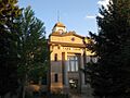
Park County Courthouse in Cody
|
||
|
||

Location within the U.S. state of Wyoming
|
||
 Wyoming's location within the U.S. |
||
| Country | ||
| State | ||
| Founded | February 15, 1909 (established) 1911 (organized) |
|
| Named for | Yellowstone National Park | |
| Seat | Cody | |
| Largest city | Cody | |
| Area | ||
| • Total | 6,967 sq mi (18,040 km2) | |
| • Land | 6,942 sq mi (17,980 km2) | |
| • Water | 25 sq mi (60 km2) 0.4%% | |
| Population
(2020)
|
||
| • Total | 29,624 | |
| • Estimate
(2023)
|
30,735 |
|
| • Density | 4.2520/sq mi (1.64172/km2) | |
| Time zone | UTC−7 (Mountain) | |
| • Summer (DST) | UTC−6 (MDT) | |
| Congressional district | At-large | |

Park County is a county located in the state of Wyoming in the United States. In 2020, about 29,624 people lived there. The main town and county seat is Cody. Park County is a very popular place for tourism. Over half of Yellowstone National Park is actually inside Park County. There are many fun places to visit, like the Buffalo Bill Historical Center, the Cody Stampede Rodeo, the old Ghost Town of Kirwin, and the western museum called Old Trail Town.
Contents
History of Park County
Wyoming became its own territory in 1868. Before that, most of the land that is now Wyoming was part of Laramie County or other unorganized areas. The Wyoming Territory was officially created on July 25, 1868. The area that is now Park County was part of different counties over time, including Carter County, Sweetwater County, and Fremont County. Later, it became part of Big Horn County until 1909.
Wyoming became a state in 1890. Park County was officially created in 1909. The county government started working in 1911. A courthouse was built between 1911 and 1912. It was later updated in 1983 and restored in 1985. The county got its name from Yellowstone National Park, which covers a large part of the county.
In the 1870s, people from Ireland and Germany moved to what would become Park County. Later, in the late 1800s and early 1900s, immigrants from England became the largest group. When the county was set up in 1911, many people living there were English immigrants or their children born in Wyoming. Many of these English families stayed connected to their home country. Some young people born in Wyoming even joined the Canadian military to fight with Britain in World War I. When the U.S. joined the war, many volunteered for the American military.
In 1913, Hot Springs County was created using parts of Park County and other nearby counties. Park County's borders changed slightly in 1929 and 1931, but they have mostly stayed the same since then.
Geography and Nature
Much of Park County's land is managed by the state or federal government. A big part of the Shoshone National Forest, which was America's first national forest, is in Park County. Also, a section of Yellowstone National Park, the very first national park, is located here. Three important rivers flow through Park County: the Greybull River, the Shoshone River, and the Clark's Fork River. The Greybull and Shoshone rivers flow into the Big Horn River, while the Clark's Fork River flows into the Yellowstone River.
The United States Census Bureau says that Park County covers a total area of about 6,967 square miles. Out of this, 6,942 square miles is land, and only 25 square miles (0.4%) is water.
Neighboring Counties
- Park County, Montana – north
- Carbon County, Montana – northeast
- Big Horn County – east
- Washakie County – east-southeast
- Hot Springs County – southeast
- Fremont County – south
- Teton County – southwest
- Gallatin County, Montana – northwest
Protected Natural Areas
- Bridger-Teton National Forest (part)
- Shoshone National Forest (part)
- Yellowstone National Park (part)
Main Roads
 U.S. Highway 14
 U.S. Highway 14A
 U.S. Highway 16
 U.S. Highway 20
 U.S. Highway 191
 U.S. Highway 212
 U.S. Highway 287
 Wyoming Highway 120
 Wyoming Highway 296
Public Transport
- Express Arrow
People of Park County
| Historical population | |||
|---|---|---|---|
| Census | Pop. | %± | |
| 1910 | 4,909 | — | |
| 1920 | 7,298 | 48.7% | |
| 1930 | 8,207 | 12.5% | |
| 1940 | 10,976 | 33.7% | |
| 1950 | 15,182 | 38.3% | |
| 1960 | 16,874 | 11.1% | |
| 1970 | 17,752 | 5.2% | |
| 1980 | 21,639 | 21.9% | |
| 1990 | 23,178 | 7.1% | |
| 2000 | 25,786 | 11.3% | |
| 2010 | 28,205 | 9.4% | |
| 2020 | 29,624 | 5.0% | |
| 2023 (est.) | 30,735 | 9.0% | |
| US Decennial Census 1870–2000 2010–2016 |
|||
In 2010, there were 28,205 people living in Park County. Most people (95.6%) were white. About 4.8% of the population was of Hispanic or Latino background. The main ancestries reported were German, English, and Irish.
The average age of people in the county was 43.6 years. About 26.1% of households had children under 18 living with them. The median income for a household was $46,637. This means half of the households earned more than this, and half earned less. About 9.0% of the population lived below the poverty line.
Towns and Communities
Cities
Towns
Census-Designated Places
These are areas that are like towns but are not officially incorporated as cities or towns.
Other Communities
Education in Park County
Children in Park County attend schools in several different school districts:
- Big Horn County School District 1
- Big Horn County School District 2
- Big Horn County School District 4
- Park County School District 1
- Park County School District 6
- Park County School District 16
It's interesting to note that the part of Park County located inside Yellowstone National Park does not belong to any school district.
Images for kids
-
The Park County Courthouse in Cody.
See also
 In Spanish: Condado de Park (Wyoming) para niños
