Carbon County, Montana facts for kids
Quick facts for kids
Carbon County
|
|
|---|---|

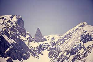
Palisades
|
|

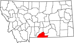
Location within the U.S. state of Montana
|
|
 Montana's location within the U.S. |
|
| Country | |
| State | |
| Founded | March 4, 1895 |
| Seat | Red Lodge |
| Largest city | Red Lodge |
| Area | |
| • Total | 2,062 sq mi (5,340 km2) |
| • Land | 2,049 sq mi (5,310 km2) |
| • Water | 13 sq mi (30 km2) 0.6% |
| Population
(2020)
|
|
| • Total | 10,473 |
| • Estimate
(2023)
|
11,419 |
| • Density | 5.0790/sq mi (1.9610/km2) |
| Time zone | UTC−7 (Mountain) |
| • Summer (DST) | UTC−6 (MDT) |
| Congressional district | 2nd |
|
|
Carbon County is a county in the state of Montana. In 2020, about 10,473 people lived there. The main town and county seat is Red Lodge.
Carbon County is part of the larger Billings area, which is a big group of cities and towns.
Contents
History of Carbon County
Carbon County got its name because of the many coal deposits found there. Coal is a type of rock that can be burned for energy. The county was officially created on March 4, 1895. It was formed from parts of two other counties: Park County and Yellowstone County.
More than 60 important historical places are in Carbon County. One of these is Petroglyph Canyon. This canyon has some of the most important rock art in Montana. Rock art means pictures carved or painted on rocks by ancient people.
The first place in Montana to find oil was in Carbon County. This happened in the Elk Basin fields in 1915.
Exploring Carbon County's Geography
Carbon County covers a total area of about 2,062 square miles. Most of this area, about 2,049 square miles, is land. The rest, about 13 square miles, is water.
Granite Peak is the tallest mountain in Montana. You can find it in Carbon County, in the Beartooth Mountains. These mountains are very tall and rugged.
The Beartooth Highway is a famous road that goes through the mountains. It connects Red Lodge to Cooke City. Many people think it's one of the most amazing mountain roads in the world. The Pryor Mountains are in the eastern part of the county. The Big Horn River also flows through this area.
Main Roads in Carbon County
Neighboring Counties
- Park County - to the west
- Stillwater County - to the north
- Yellowstone County - to the northeast
- Big Horn County - to the east
- Big Horn County, Wyoming - to the southeast
- Park County, Wyoming - to the south
Protected Natural Areas
Carbon County is home to parts of several protected natural areas. These places help keep nature safe and beautiful.
- Bighorn Canyon National Recreation Area (part of it)
- Custer National Forest (part of it)
- Gallatin National Forest (part of it)
People of Carbon County
| Historical population | |||
|---|---|---|---|
| Census | Pop. | %± | |
| 1900 | 7,533 | — | |
| 1910 | 13,962 | 85.3% | |
| 1920 | 15,279 | 9.4% | |
| 1930 | 12,571 | −17.7% | |
| 1940 | 11,865 | −5.6% | |
| 1950 | 10,241 | −13.7% | |
| 1960 | 8,317 | −18.8% | |
| 1970 | 7,080 | −14.9% | |
| 1980 | 8,099 | 14.4% | |
| 1990 | 8,080 | −0.2% | |
| 2000 | 9,552 | 18.2% | |
| 2010 | 10,078 | 5.5% | |
| 2020 | 10,473 | 3.9% | |
| 2023 (est.) | 11,419 | 13.3% | |
| U.S. Decennial Census 1790–1960, 1900–1990, 1990–2000, 2010–2020, 2023 |
|||
Population in 2020
In 2020, the census counted 10,473 people living in Carbon County.
Population in 2010
In 2010, there were 10,078 people living in the county. About 97.2% of the people were white. A small number were American Indian, Black, or Asian. About 1.9% of the people were of Hispanic or Latino background.
The average age of people in Carbon County was about 48 years old.
Carbon County's Economy
In the past, coal mining was the biggest industry in Carbon County. Many people worked in the mines.
Today, the economy is different. It mostly depends on farming, outdoor activities, and people visiting the area. This means agriculture, recreation, and tourism are very important.
In 2009, some of the biggest employers were Beartooth Hospital & Health Center, Red Lodge Mountain (a ski resort), and the Red Lodge Pizza Company.
A large wind farm called Mud Springs Wind Ranch started being built in 2014. It has 120 wind turbines and helps create clean energy. It is located near Bridger.
Communities in Carbon County
City
- Red Lodge (This is the main town and county seat.)
Towns
Census-Designated Places
These are areas that are like towns but are not officially governed as towns.
Unincorporated Communities
These are small settlements that are not officially part of any town or city.
Former Communities
These are places that used to be communities but are no longer active settlements.
- Carbonado
- Chance
- Chickentown
- Fairbanks
- Gebo
- Golden
- International
- New Caledonia
- Riverview
- Scotch Coulee
- Stringtown
See also
 In Spanish: Condado de Carbon (Montana) para niños
 | Leon Lynch |
 | Milton P. Webster |
 | Ferdinand Smith |


