Belfry, Montana facts for kids
Quick facts for kids
Belfry, Montana
|
|
|---|---|

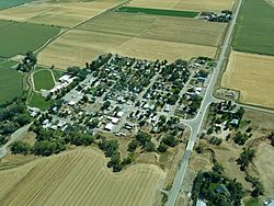
Aerial view of Belfry
|
|

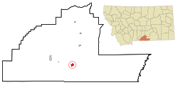
Location of Belfry, Montana
|
|
| Country | United States |
| State | Montana |
| County | Carbon |
| Area | |
| • Total | 1.72 sq mi (4.45 km2) |
| • Land | 1.67 sq mi (4.31 km2) |
| • Water | 0.05 sq mi (0.14 km2) |
| Elevation | 3,862 ft (1,177 m) |
| Population
(2020)
|
|
| • Total | 193 |
| • Density | 115.92/sq mi (44.76/km2) |
| Time zone | UTC-7 (Mountain (MST)) |
| • Summer (DST) | UTC-6 (MDT) |
| ZIP code |
59008
|
| Area code(s) | 406 |
| FIPS code | 30-04900 |
| GNIS feature ID | 0802021 |
Belfry is a small community in Carbon County, Montana, in the United States. It's known as a census-designated place (CDP). This means it's an area that looks like a town but isn't officially a city. Belfry is part of the larger Billings Metropolitan Area.
In 2010, about 218 people lived here. By 2020, the population was 193. Belfry is located about 11 miles from the Wyoming border. It's roughly halfway between the cities of Billings, Montana, and Cody, Wyoming.
Belfry is mostly a farming community. Farmers here grow crops like sugar beets, alfalfa, and corn for animal feed. Ranchers also raise cattle and sheep. The farms get their water from the Clarks Fork Yellowstone River. This water comes through special ditch systems that have been used for over 100 years.
Long ago, in the early 1900s, a railway line came to Belfry. It even had a branch that went to the coal mines in Bearcreek, Montana. When the mines closed and the railway was taken away, fewer people lived in Belfry. Today, the community has a general store, a bar, and a restaurant. There's also a small place that combines a bar, restaurant, and casino.
The town got its name from a local doctor. The post office first opened on February 26, 1906. Mary Hall was the first person in charge of the post office. The town grew because of the construction of the Yellowstone Park Railroad.
Contents
Geography
Belfry is located in the south-central part of Carbon County. Its exact location is 45°8′29″N 109°0′28″W / 45.14139°N 109.00778°W.
The area of Belfry is about 4.45 square kilometers (1.72 square miles). Most of this area is land (4.31 sq km or 1.67 sq mi). A small part, about 0.14 sq km (0.05 sq mi), is water. The Clarks Fork of the Yellowstone River flows just to the east of the main part of town.
Population Information
| Historical population | |||
|---|---|---|---|
| Census | Pop. | %± | |
| 2020 | 193 | — | |
| U.S. Decennial Census | |||
In the year 2000, there were 219 people living in Belfry. These people lived in 98 households. About 53 of these households were families. The population density was about 115 people per square mile.
About 27.4% of the people in Belfry were under 18 years old. About 21% were 65 years old or older. The average age of people in Belfry was 41 years.
Schools
Belfry has its own school district. There are two schools, an elementary school and a high school. They are in buildings right next to each other. About 80 students go to Belfry schools. These students come from Belfry and nearby towns like Bearcreek, Montana, Bridger, Montana, and Clark, Wyoming. The school's mascot is the bat, and their sports teams are called the Belfry Bats.
See also
 In Spanish: Belfry (Montana) para niños
 | Claudette Colvin |
 | Myrlie Evers-Williams |
 | Alberta Odell Jones |

