Bridger, Montana facts for kids
Quick facts for kids
Bridger, Montana
|
|
|---|---|
 |
|

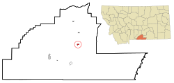
Location of Bridger, Montana
|
|
| Country | United States |
| State | Montana |
| County | Carbon |
| Area | |
| • Total | 0.80 sq mi (2.06 km2) |
| • Land | 0.80 sq mi (2.06 km2) |
| • Water | 0.00 sq mi (0.00 km2) |
| Elevation | 3,685 ft (1,123 m) |
| Population
(2020)
|
|
| • Total | 662 |
| • Density | 830.61/sq mi (320.63/km2) |
| Time zone | UTC-7 (Mountain (MST)) |
| • Summer (DST) | UTC-6 (MDT) |
| ZIP code |
59014
|
| Area code(s) | 406 |
| FIPS code | 30-09475 |
| GNIS feature ID | 2411726 |
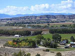
Bridger is a small town in Carbon County, Montana, United States. It is part of the larger Billings Metropolitan Area. In 2020, about 662 people lived here.
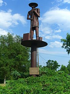
The town was named after a famous scout named Jim Bridger. One of the first settlers, George Town, wanted the town to be named after his old friend, Jim Bridger, instead of himself. The historic Bridger Trail also passes near the town.
Contents
History of Bridger
The Bridger Post Office officially opened on October 29, 1898. Its first postmaster was Jno. M. Babcock.
In December 2014, work started on a big wind farm called Mud Springs Wind Ranch. It was built about 12 miles southeast of Bridger. This project, later renamed Pryor Mountain Wind Project, was finished in late 2020. It uses many wind turbines to create electricity.
Where is Bridger Located?
Bridger is located on Montana Secondary Highway 310, which goes right through the town. The Clarks Fork of the Yellowstone River flows along the east side of the community. A railroad track, once part of the Chicago, Burlington and Quincy Railroad, also runs just east of the river.
The United States Census Bureau says that Bridger covers about 0.80 square miles (2.06 square kilometers) of land. There is no water area within the town limits.
Bridger's Climate
Bridger has a semi-arid climate. This means it's usually dry, but not a desert. It gets some rain, but not a lot.
| Climate data for Bridger, Montana, 1991–2020 normals, extremes 1900–present | |||||||||||||
|---|---|---|---|---|---|---|---|---|---|---|---|---|---|
| Month | Jan | Feb | Mar | Apr | May | Jun | Jul | Aug | Sep | Oct | Nov | Dec | Year |
| Record high °F (°C) | 73 (23) |
71 (22) |
81 (27) |
89 (32) |
98 (37) |
106 (41) |
110 (43) |
106 (41) |
105 (41) |
92 (33) |
78 (26) |
72 (22) |
110 (43) |
| Mean maximum °F (°C) | 54.0 (12.2) |
56.1 (13.4) |
69.9 (21.1) |
80.4 (26.9) |
87.2 (30.7) |
94.4 (34.7) |
100.2 (37.9) |
98.5 (36.9) |
93.7 (34.3) |
81.8 (27.7) |
67.0 (19.4) |
55.5 (13.1) |
100.9 (38.3) |
| Mean daily maximum °F (°C) | 35.4 (1.9) |
38.9 (3.8) |
50.4 (10.2) |
57.7 (14.3) |
67.4 (19.7) |
77.3 (25.2) |
87.2 (30.7) |
86.3 (30.2) |
75.3 (24.1) |
59.7 (15.4) |
45.8 (7.7) |
35.9 (2.2) |
59.8 (15.4) |
| Daily mean °F (°C) | 24.2 (−4.3) |
27.0 (−2.8) |
36.4 (2.4) |
43.8 (6.6) |
53.5 (11.9) |
62.1 (16.7) |
70.2 (21.2) |
68.3 (20.2) |
58.4 (14.7) |
45.7 (7.6) |
34.0 (1.1) |
25.1 (−3.8) |
45.7 (7.6) |
| Mean daily minimum °F (°C) | 12.9 (−10.6) |
15.1 (−9.4) |
22.4 (−5.3) |
29.9 (−1.2) |
39.6 (4.2) |
47.0 (8.3) |
53.1 (11.7) |
50.2 (10.1) |
41.5 (5.3) |
31.7 (−0.2) |
22.2 (−5.4) |
14.2 (−9.9) |
31.6 (−0.2) |
| Mean minimum °F (°C) | −9.0 (−22.8) |
−3.3 (−19.6) |
4.9 (−15.1) |
16.6 (−8.6) |
27.7 (−2.4) |
36.4 (2.4) |
44.4 (6.9) |
40.3 (4.6) |
31.3 (−0.4) |
16.7 (−8.5) |
2.0 (−16.7) |
−6.6 (−21.4) |
−15.6 (−26.4) |
| Record low °F (°C) | −34 (−37) |
−35 (−37) |
−26 (−32) |
−4 (−20) |
16 (−9) |
27 (−3) |
35 (2) |
28 (−2) |
9 (−13) |
−13 (−25) |
−26 (−32) |
−37 (−38) |
−37 (−38) |
| Average precipitation inches (mm) | 0.29 (7.4) |
0.33 (8.4) |
0.47 (12) |
1.57 (40) |
2.25 (57) |
1.80 (46) |
0.83 (21) |
0.61 (15) |
1.15 (29) |
1.23 (31) |
0.6 (15) |
0.37 (9.4) |
11.5 (291.2) |
| Average snowfall inches (cm) | 5.1 (13) |
4.5 (11) |
3.1 (7.9) |
3.5 (8.9) |
0.7 (1.8) |
0.0 (0.0) |
0.0 (0.0) |
0.0 (0.0) |
0.0 (0.0) |
2.0 (5.1) |
4.7 (12) |
6.7 (17) |
30.3 (76.7) |
| Average precipitation days (≥ 0.01 in) | 1.9 | 2.3 | 3.2 | 6.3 | 8.4 | 8.2 | 4.3 | 4.5 | 4.6 | 5.0 | 2.8 | 2.8 | 54.3 |
| Average snowy days (≥ 0.1 in) | 2.2 | 2.4 | 1.4 | 1.3 | 0.2 | 0.0 | 0.0 | 0.0 | 0.0 | 0.8 | 1.9 | 2.7 | 12.9 |
| Source 1: NOAA | |||||||||||||
| Source 2: National Weather Service | |||||||||||||
People Living in Bridger
| Historical population | |||
|---|---|---|---|
| Census | Pop. | %± | |
| 1910 | 514 | — | |
| 1920 | 679 | 32.1% | |
| 1930 | 567 | −16.5% | |
| 1940 | 783 | 38.1% | |
| 1950 | 854 | 9.1% | |
| 1960 | 824 | −3.5% | |
| 1970 | 717 | −13.0% | |
| 1980 | 724 | 1.0% | |
| 1990 | 692 | −4.4% | |
| 2000 | 745 | 7.7% | |
| 2010 | 708 | −5.0% | |
| 2020 | 662 | −6.5% | |
| U.S. Decennial Census | |||
In 2010, about 708 people lived in Bridger. There were 315 households, and 195 of them were families. Most people living in Bridger were White (95.5%). A small number were Native American (2.7%) or from other backgrounds.
About 22% of the people were under 18 years old. The average age in Bridger was 45.7 years.
Education in Bridger
Bridger Public Schools provides education for students from kindergarten all the way through 12th grade. The school teams are known as the Scouts. Bridger High School is a Class C school, which means it's a smaller school.
The town also has the Bridger Public Library, which serves the community.
Famous People from Bridger
- David Thatcher was born in Bridger. He was a Staff Sergeant in the United States Air Force. He was the last survivor of the "Ruptured Duck" crew during the famous Doolittle Raid in World War II.
See also
 In Spanish: Bridger (condado de Carbon, Montana) para niños
 | Jessica Watkins |
 | Robert Henry Lawrence Jr. |
 | Mae Jemison |
 | Sian Proctor |
 | Guion Bluford |


