Bridger Trail facts for kids
The Bridger Trail, also known as the Bridger Road, was an important path used by pioneers and gold seekers in the 1860s. It helped people travel from the Oregon Trail in Wyoming to the gold fields of Montana.
In 1863, gold was found in Virginia City, Montana. This discovery made many people want to travel there. A direct route, called the Bozeman Trail, went through land where Native American tribes like the Sioux, Cheyenne, and Arapaho lived. These tribes were concerned about the many settlers crossing their lands, which often led to conflicts.
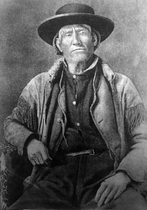
Because of these dangers, in 1864, Colonel William O. Collins from Fort Laramie National Historic Site asked Jim Bridger to find a new, safer way. Jim Bridger was a very experienced guide who knew the western lands well. He had explored the Bighorn Basin area before. The new path he found ran for about 425 miles (684 km). It went west of the Bighorn Mountains, through lands mainly used by the Crow and Shoshone people.
In 1864, ten groups of wagons used the Bridger Trail. Jim Bridger himself guided two of these groups. The next year, conflicts on the Bozeman Trail became even more serious. Jim Bridger then spent his time guiding military groups instead of settlers. He never led people along the Bridger Trail again.
The Trail's Path
Quick facts for kids |
|
|
Bridger Immigrant Road-Dry Creek Crossing
|
|
| Nearest city | Cody, Wyoming |
|---|---|
| Area | 5 acres (2.0 ha) |
| Built | 1864 |
| NRHP reference No. | 75001900 |
| Added to NRHP | January 17, 1975 |
|
Bridger Immigrant Road---Waltman Crossing
|
|
| Nearest city | Casper, Wyoming |
|---|---|
| Area | 5 acres (2.0 ha) |
| NRHP reference No. | 75001905 |
| Added to NRHP | January 17, 1975 |
The Bridger Trail started from the Oregon Trail near Fort Caspar in central Wyoming. It headed northwest. The trail crossed Badwater Creek near Lysite, Wyoming. It then followed Bridger Creek into the Bridger Mountains. These mountains are just west of the southern Bighorn Mountains.
After crossing the mountains, the trail went down to Kirby Creek. This creek meets the Bighorn River near the town of Lucerne. From there, the trail turned north, following the Bighorn River. At the mouth of the Nowood River, the trail turned northeast towards the Greybull River.
After crossing the Greybull River, settlers crossed the Shoshone River near Powell. They continued north into Montana. The trail then went through Bridger Canyon. It met the Clarks Fork Yellowstone River and followed it past the town of Bridger, Montana. Finally, it joined the Bozeman Trail about 10 miles south of Laurel, Montana. Both trails then continued west together to the gold mines in Virginia City. The journey could take as little as 34 days. However, many wagon trains stopped to look for gold along the way.
The Bridger Trail was not as good for wagon trains as the Bozeman Trail in some ways. It had less grass for animals and fewer water sources. Still, in 1864, it helped bring about 25% of the new people to Virginia City. At least ten wagon trains used the trail that year. The largest one had 129 wagons and carried between 350 and 450 people.
What Remains Today
Not much of the original Bridger Trail can be seen today. Some faint tracks are still visible in Fremont County and Hot Springs County. There are also two places where settlers carved their names into rock. One is on a sandstone cliff near Bridger Creek. The other is at Signature Rock, between Byron, Wyoming and Cowley, Wyoming.
The trail was not always a clear path. But in places like stream crossings, where the land made it hard to choose a route, the clearest traces remain. Two parts of the Bridger Road are listed on the National Register of Historic Places. The Dry Creek crossing is in Big Horn County near U.S. Route 14/16/20. The Waltman crossing is in Natrona County where the Bridger Road crosses U.S. 20/U.S. Route 26. Both sites cover about 5 acres (2 hectares) each.
The Dry Creek Crossing and Waltman Crossing sites were added to the National Register of Historic Places on January 17, 1975.
See also
 In Spanish: Ruta Bridger para niños
 | Calvin Brent |
 | Walter T. Bailey |
 | Martha Cassell Thompson |
 | Alberta Jeannette Cassell |


