
Bighorn Basin facts for kids


The Bighorn Basin is a large, flat area of land, like a giant bowl, in north-central Wyoming, United States. It's about 100 miles (160 km) wide. High mountains surround it: the Absaroka Range to the west, the Pryor Mountains to the north, the Bighorn Mountains to the east, and the Owl Creek Mountains and Bridger Mountains to the south.
The Bighorn River flows into the basin from the south. It starts as the Wind River and changes its name to Bighorn as it enters this area. The region is quite dry, getting only about 6–10 inches (15–25 cm) of rain each year.
Some of the biggest towns in the basin are Cody, Thermopolis, Worland, and Powell. Farmers here grow crops like sugar beets, pinto beans, sunflowers, barley, oats, corn, and alfalfa hay. They use irrigation to water their fields.
Contents
History of the Bighorn Basin
The Bighorn Basin has a rich history!
Early Explorers and Trails
In 1807, an explorer named John Colter was one of the first non-Native Americans to explore the basin. He found hot springs and geysers west of Cody, which people later called "Colter's Hell" because of the steaming, bubbling landscape.
Later, in 1864, Jim Bridger created the Bridger Trail. This trail connected the Oregon Trail in the south to Montana. It was a very important route because another trail, the Bozeman Trail, was closed due to conflicts with Native American tribes during Red Cloud's War.
Settlement and Development
Around the early 1900s, ranchers began settling the Bighorn Basin. One famous rancher was William "Buffalo Bill" Cody. He helped found the town of Cody and owned a lot of land near the Shoshone River.
In 1901, the Chicago, Burlington and Quincy Railroad built a train line to Cody and eventually through the whole basin. This helped bring people and goods to the area. In 1904, Buffalo Bill also helped start the Shoshone project. This was the first big government project to bring water for farming to the western part of the basin. It led to the building of the Buffalo Bill Dam and a large reservoir.
Outlaws and Internment
The wealth in the region also attracted outlaws. The famous outlaw Butch Cassidy lived near Meeteetse for a while. He was arrested for horse theft and sent to prison. After he was released, he formed the Wild Bunch gang, which operated from the Hole-in-the-Wall area, southeast of the Bighorn Basin.
During World War II, from 1942 to 1945, one of the ten Japanese American internment camps in the United States was located in Park County, in the western part of the basin. It was called the Heart Mountain Relocation Center, named after nearby Heart Mountain. At its busiest, over 10,000 people were held there.
Geology of the Bighorn Basin

The Bighorn Basin is like a giant bowl in the Earth's crust. It's filled with more than 20,000 feet (6,000 m) of different types of rocks, laid down over millions of years. These rocks range in age from the Cambrian period to the Miocene period.
Oil, Uranium, and Fossils
Since the early 1900s, the basin has been a very important source of oil. It has produced over 1.4 billion barrels of oil! Much of this oil comes from a rock layer called the Pennsylvanian Tensleep Sandstone. Other important oil sources include the Mississippian Madison Limestone, the Permian Phosphoria Formation, and the Cretaceous Frontier Sandstone.
Some uranium has also been mined in the northern part of the basin, near the Bighorn Mountains.
The eastern part of the basin is famous for its many fossils. For example, the Cretaceous period Cloverly Formation has yielded many dinosaur fossils! Scientists have also studied the rocks here to learn about a time when the Earth got much warmer, called the Paleocene-Eocene Thermal Maximum (PETM). These studies show that the Bighorn Basin became drier during this warm period, with wet and dry seasons changing the environment. This also affected the ancient plants and animals living there.
Communities in the Bighorn Basin
Notable Features
Images for kids
-
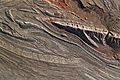
Folds and geological structures of the northern Bighorn Basin, seen from the ISS in 2021.

