
Basin, Wyoming facts for kids
Quick facts for kids
Basin, Wyoming
|
||
|---|---|---|

Downtown Basin, Wyoming
|
||
|
||
| Nickname(s):
Lilac City
|
||

Location of Basin in Big Horn County, Wyoming.
|
||

Basin, Wyoming
Location in the United States
|
||
| Country | United States | |
| State | Wyoming | |
| County | Big Horn | |
| Incorporated | 1902 | |
| Government | ||
| • Type | Mayor-Council | |
| Area | ||
| • Total | 2.39 sq mi (6.19 km2) | |
| • Land | 2.36 sq mi (6.12 km2) | |
| • Water | 0.03 sq mi (0.07 km2) | |
| Elevation | 3,878 ft (1,182 m) | |
| Population
(2020)
|
||
| • Total | 1,288 | |
| • Estimate
(2023)
|
1,330 | |
| • Density | 542.53/sq mi (209.47/km2) | |
| Time zone | UTC-7 (Mountain (MST)) | |
| • Summer (DST) | UTC-6 (MDT) | |
| ZIP code |
82410
|
|
| Area code(s) | 307 | |
| FIPS code | 56-05320 | |
| GNIS feature ID | 1585173 | |

Basin is a town in Wyoming, United States. It's the main town, or county seat, of Big Horn County. In 2020, about 1,288 people lived there. Basin is located near the middle of the Bighorn Basin, with the Big Horn River flowing east of the town. The town's post office, built in 1919, is a special building listed on the National Register of Historic Places.
Contents
About Basin, Wyoming
Basin is located at coordinates 44°22′44″N 108°2′35″W / 44.37889°N 108.04306°W. This means it is in the northern part of the United States. The town covers an area of about 2.43 square miles (6.29 square kilometers). Most of this area is land, with a small part being water.
Basin is known as "The Lilac City" because of the many lilac bushes. Every summer, the town hosts the Big Horn County Fair. This fair is a fun event for everyone in the area.
Basin's Climate
Basin has a cold desert climate. This means it is usually dry and can have very hot summers and cold winters. In fact, Basin holds the record for the highest temperature ever recorded in Wyoming. It reached 115 degrees Fahrenheit (46 degrees Celsius) on August 8, 1983. It also holds state records for high temperatures in April and July.
Summers in the Bighorn Basin, where Basin is located, are often hotter than in other parts of Wyoming. Because the air is very dry, temperatures can change a lot between day and night. Snowfall is usually light in this region. Sometimes, there is no measurable rain or snow for a whole month.
On average, Basin has about 49 days each year where the temperature reaches 90 degrees Fahrenheit (32 degrees Celsius) or higher. About 5 days are hotter than 100 degrees Fahrenheit (38 degrees Celsius). Winters are cold, with about 176 nights where the temperature drops to 32 degrees Fahrenheit (0 degrees Celsius) or lower. The coldest temperature ever recorded in Basin was -51 degrees Fahrenheit (-46 degrees Celsius) in 1899.
| Climate data for Basin 1991–2020 normals, extremes 1898–present | |||||||||||||
|---|---|---|---|---|---|---|---|---|---|---|---|---|---|
| Month | Jan | Feb | Mar | Apr | May | Jun | Jul | Aug | Sep | Oct | Nov | Dec | Year |
| Record high °F (°C) | 64 (18) |
73 (23) |
82 (28) |
90 (32) |
99 (37) |
110 (43) |
112 (44) |
115 (46) |
102 (39) |
91 (33) |
77 (25) |
67 (19) |
115 (46) |
| Mean maximum °F (°C) | 47.9 (8.8) |
55.1 (12.8) |
72.3 (22.4) |
81.9 (27.7) |
89.0 (31.7) |
97.4 (36.3) |
101.9 (38.8) |
99.8 (37.7) |
94.7 (34.8) |
82.9 (28.3) |
64.2 (17.9) |
51.3 (10.7) |
102.4 (39.1) |
| Mean daily maximum °F (°C) | 32.4 (0.2) |
39.1 (3.9) |
54.1 (12.3) |
63.0 (17.2) |
72.8 (22.7) |
83.7 (28.7) |
92.7 (33.7) |
91.0 (32.8) |
79.3 (26.3) |
62.9 (17.2) |
46.4 (8.0) |
33.8 (1.0) |
62.6 (17.0) |
| Daily mean °F (°C) | 20.6 (−6.3) |
26.8 (−2.9) |
40.7 (4.8) |
49.8 (9.9) |
59.8 (15.4) |
69.2 (20.7) |
76.5 (24.7) |
74.1 (23.4) |
63.4 (17.4) |
49.2 (9.6) |
34.6 (1.4) |
22.6 (−5.2) |
48.9 (9.4) |
| Mean daily minimum °F (°C) | 8.8 (−12.9) |
14.6 (−9.7) |
27.4 (−2.6) |
36.5 (2.5) |
46.8 (8.2) |
54.7 (12.6) |
60.3 (15.7) |
57.2 (14.0) |
47.5 (8.6) |
35.5 (1.9) |
22.8 (−5.1) |
11.4 (−11.4) |
35.3 (1.8) |
| Mean minimum °F (°C) | −16.3 (−26.8) |
−10.3 (−23.5) |
5.1 (−14.9) |
19.2 (−7.1) |
28.8 (−1.8) |
40.4 (4.7) |
48.6 (9.2) |
43.9 (6.6) |
32.0 (0.0) |
17.1 (−8.3) |
−0.6 (−18.1) |
−9.7 (−23.2) |
−22.3 (−30.2) |
| Record low °F (°C) | −43 (−42) |
−51 (−46) |
−31 (−35) |
−4 (−20) |
18 (−8) |
30 (−1) |
36 (2) |
34 (1) |
14 (−10) |
−7 (−22) |
−28 (−33) |
−43 (−42) |
−51 (−46) |
| Average precipitation inches (mm) | 0.24 (6.1) |
0.32 (8.1) |
0.31 (7.9) |
0.75 (19) |
1.37 (35) |
1.04 (26) |
0.41 (10) |
0.32 (8.1) |
0.95 (24) |
0.79 (20) |
0.36 (9.1) |
0.30 (7.6) |
7.16 (180.9) |
| Average snowfall inches (cm) | 3.4 (8.6) |
4.1 (10) |
2.3 (5.8) |
1.5 (3.8) |
0.1 (0.25) |
0.0 (0.0) |
0.0 (0.0) |
0.0 (0.0) |
0.2 (0.51) |
1.5 (3.8) |
3.0 (7.6) |
4.0 (10) |
20.1 (50.36) |
| Average precipitation days (≥ 0.01 in) | 3.4 | 3.6 | 3.1 | 5.1 | 7.1 | 6.0 | 3.2 | 3.6 | 4.7 | 4.0 | 3.3 | 3.3 | 50.4 |
| Average snowy days (≥ 0.1 in) | 2.5 | 2.6 | 1.4 | 0.7 | 0.1 | 0.0 | 0.0 | 0.0 | 0.1 | 0.7 | 1.7 | 2.3 | 12.1 |
| Source: NOAA | |||||||||||||
Population of Basin
The population of Basin has changed over the years. In 1910, there were 763 people living in the town. By 2020, the population had grown to 1,288 people. The latest estimate for 2023 suggests the population is around 1,330.
| Historical population | |||
|---|---|---|---|
| Census | Pop. | %± | |
| 1910 | 763 | — | |
| 1920 | 1,088 | 42.6% | |
| 1930 | 903 | −17.0% | |
| 1940 | 1,099 | 21.7% | |
| 1950 | 1,220 | 11.0% | |
| 1960 | 1,319 | 8.1% | |
| 1970 | 1,145 | −13.2% | |
| 1980 | 1,349 | 17.8% | |
| 1990 | 1,180 | −12.5% | |
| 2000 | 1,238 | 4.9% | |
| 2010 | 1,285 | 3.8% | |
| 2020 | 1,288 | 0.2% | |
| 2023 (est.) | 1,330 | 3.5% | |
| U.S. Decennial Census | |||
People in Basin (2010 Census)
According to the 2010 census, there were 1,285 people living in Basin. These people lived in 520 households. Most of the residents were White (94.2%). There were also small percentages of African American, Native American, and Asian residents. About 5.4% of the population identified as Hispanic or Latino.
The average age of people in Basin was 46.4 years. About 20% of residents were under 18 years old. About 24% of residents were 65 years or older. The number of males and females in the town was almost equal.
Education in Basin
Students in Basin attend public schools managed by Big Horn County School District #4. The district has three schools, all located on one campus.
- Laura Irwin Elementary School serves students from kindergarten to 5th grade.
- Riverside Middle School teaches students in grades 6 through 8.
- Riverside High School is for students in grades 9 through 12.
The middle school and high school share one building. This building is right next to the elementary school. Basin also has a public library. It is part of the Big Horn County Library System.
Transportation
Bus service to Basin is provided by a company called Express Arrow. This service helps people travel to and from the town.
Images for kids
-
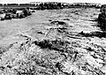
Flooding of the Greybull River near Basin, Wyoming in June 1963.

See also
 In Spanish: Basin (Wyoming) para niños
